


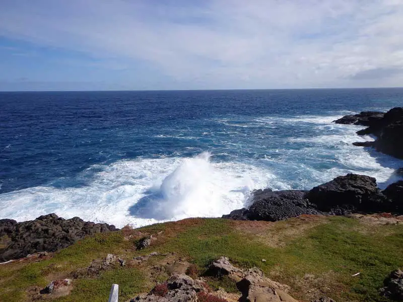
Thunder Bay and False Entrance are located on the west coast of the continent, just a short distance from Steel Point, its most westerly extremity. The scenery in these parts is rugged with soft beach sand and surf was creating waterfalls along the rocky headland. Rock pools, like giant spa baths, are frequently inundated with large waves and Thunder Bay itself is an incredible rocky bay full of reefs and breaking waves. It is here that one of Australia’s most powerful blowholes is found. False Entrance was so named because many mariners mistook the entrance to the bay as the passage between the mainland and Dirk Hartog Island. Heading towards False Entrance, you will have unbelievable views of the Indian Ocean; these very high cliffs go all the way south to Kalbarri. The track north from Flase Entrance leads to Step Point, the most westerly point of mainland Australia.
In the False Entrance area the cliffs are over 100 metres high and are very dangerous. On the cliffs are two large blow holes and if conditions are right, water is forced up from the ocean below. At one of the cliffs tops is a place called ‘The Washing Machine’. A large horse shoe shaped section of the cliff has fallen away leaving a rugged and spectacular viewing platform.
- More
- More
- More
- More
- More
- More
- More
- More
- More
- More

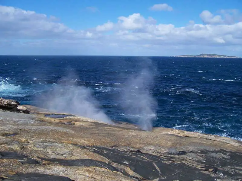
The coastline near Albany in Western Australia is rugged and strikingly beautiful. Among the natural features that are a must to be seen by visitors to Albany are the Natural Bridge, The Gap and the Blowhole.
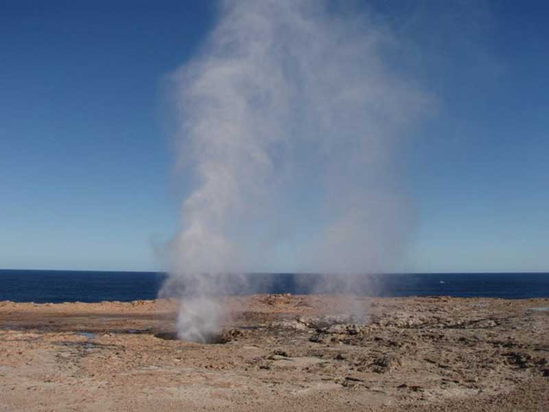
Nort far from the sadly neglected lighthouse at Point Quobba near the Western Australian town of Carnarvon, there are a series of powerful blowholes. Discovered by Europeans as recently as 1911, with the right sea conditions these blowholes can put on a spectacular display of waterspouts. During World War 2 the Air Force bombed the main blowhole to try and lessen it’s effect. It was thought that the spout could be used as a navigation marker by enemy ships, even as far as 50 kilometres offshore. The sea here is actively eroding the shoreline leaving jagged rocks, and little soil or vegetation remains up to 50 metres inland. Standing on the edge of the cliffs by the blowholes (below and left) is not recommended as over 30 people have died here after being washed off rocks by king waves. The access road is not sealed but can be traversed with a 2WD vehicle though a 4WD vehicle is recommended. This stretch of coast is virtually untouched and provides spectacular views of Cape Cuvier along with exceptional fishing and surfing.
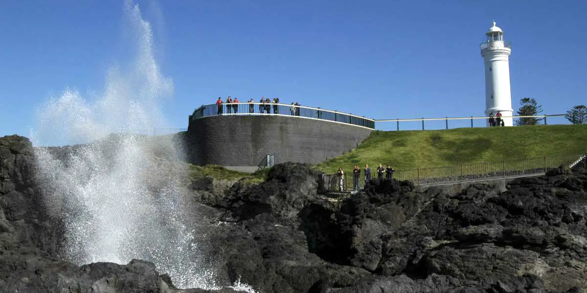
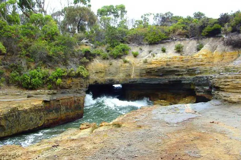
The main Kiama Blow Holeat Kiama NSW was discovered by George Bass on his voyage of coastal exploration on December 6, 1797, after anchoring his whaleboat in the sheltered bay which became Kiama Harbour. Bass was not, in fact, the first to discover the Kiama Blow Hole, as local Aboriginals had for generations referred to it as Khanterintee. In January 1889 a performer by the name of Charles Jackson attracted large crowds to see his crossings of the mouth of the Blow Hole on a tightrope. A smaller “little Blow Hole” is located a few minutes south of the main Blow Hole & performs best under moderate seas.
There are some beautiful bays around the Tasman peninsula, as well as some unique and amazing rock formations. Eaglehawk Nest is a good place from which too see the beautiful coastal rock formations of the Blowhole, Devils Kitchen, Tasmans Arch, Tessellated Pavement and Waterfall Bay. It is situated at the entrance point to the Tasman Peninsula. Just east of Eaglehawk Nest is Taranna and the popular Tasmanian Devil Park. East again are Koonya, Premaydena and Saltwater River which home the remains of the penal outstations and the Coal Mines Station. To the south of the Tasman Peninsula is Remarkable Cave and the pretty Tasman National Park.
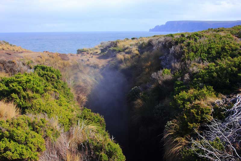
Situated in The Tasman National Park, Maingon Blowhole can be reached via a walk which traverses the Tasman Peninsula, to the south of Hobart. The sea cliffs on this section of the coastline are amongst the highest and most rugged in the world. On the journey towards Crescent Beach there is a formidable gulch that feeds Maingon Blowhole which is very deep. Attempts to see the bottom should be avoided without the use of protective ropes due to the unstable surrounds – the water can be heard crashing far below, however.
A blowhole exists on the coastline near the town of Bechino in Tasmania. The blowhole is located near the Esplanade Reserve. Nearby is also the Rocking Rock, 80 tonnes of rocking granite, which has been rocking for thousands of years. Bicheno (pop. 700) is one of Tasmania’s most beautiful towns and one of the most popular holiday destinations. It began life as a sealing and whaling town and then transitioned to a coal mining port (shipping coal mined inland at Fingal), but today crayfishing is the largest industry.
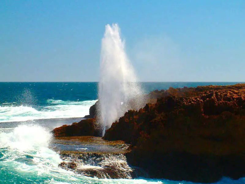
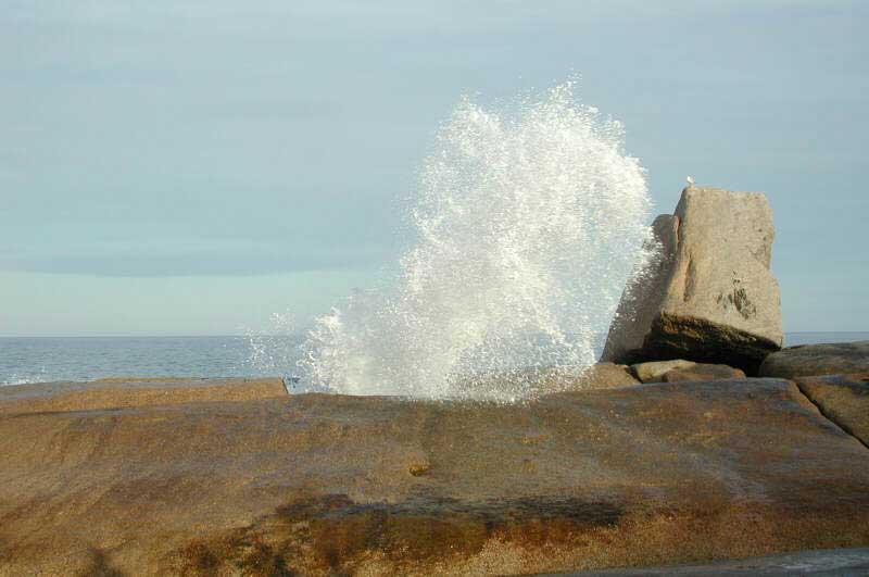
A series of blowholes can be found on Victoria’s rugged south west coast at Cape Bridgewater near Portland. Spray from the waves comes over the tops of the 25 m cliffs. Historical notes from the 1880’s record that the blow holes sounded just like cannons and could easily be heard at Portland 19 km away. The blowholes are actually rock tunnels that have been etched out of the volcanic rock at the base of the cliffs by the waves. A number of the tunnels have collapsed through erosion. During rough seas, the waves thump into the rocks and sending spectacular spouts of spray skywards. The local Aborigines attached many legends to this phenomenon and there are a number of middens along the cliff tops.
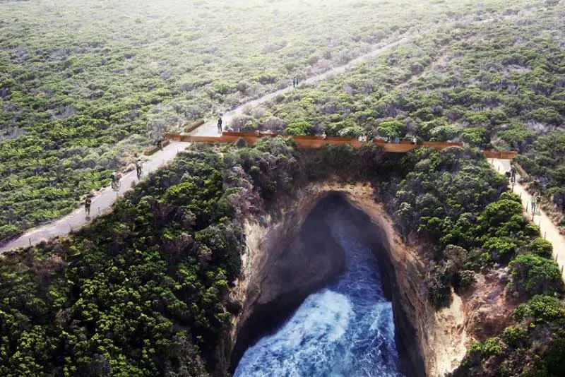
Port Campbell is an attractive, almost sleepy, windswept little fishing village which is set on a natural gorge at the mouth of Campbells Creek on the south west coast of Victoria. It is also in close proximity to one of the most scenic and most photographed sections of the Australian coastline on the famous Great Ocean Road. Here, in the Port Campbell National Park, are found the remains of London Bridge (its main arch has collapsed through wave erosion), Loch Ard Gorge, the Twelve Apostles, the Bay of Islands and Australia’s biggest blowhole, all of which have been carved by centuries of wave erosion out of the sandstone cliffs. Like the Tasman Peninsula blowhole, the Port Campbell blowhole is located a considerable distance from the cliff face from which its long tunnel eminates. The blowhole itself is in a large crater which has a viewing platform above it.
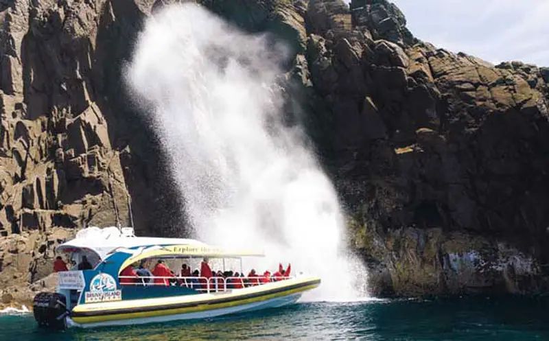
One of the natural wonders to be found on the coast of South Bruny Island is Breathing Rock, a cavern in the rock face near water level that fills with air as the waves wash out and then as the waves washed back up into it, the air is forced back out with a huge spray. Those who travelled the south and south eastern coast of Tasmania by kayak agree that Bruny Island’s Breathing Rock is impressive but is described as ‘quite ordinary’ when compared to the huge ‘breathing rock’ on DeWitt Island in the Maatsuyker Group on the south west coast of Tasmania.
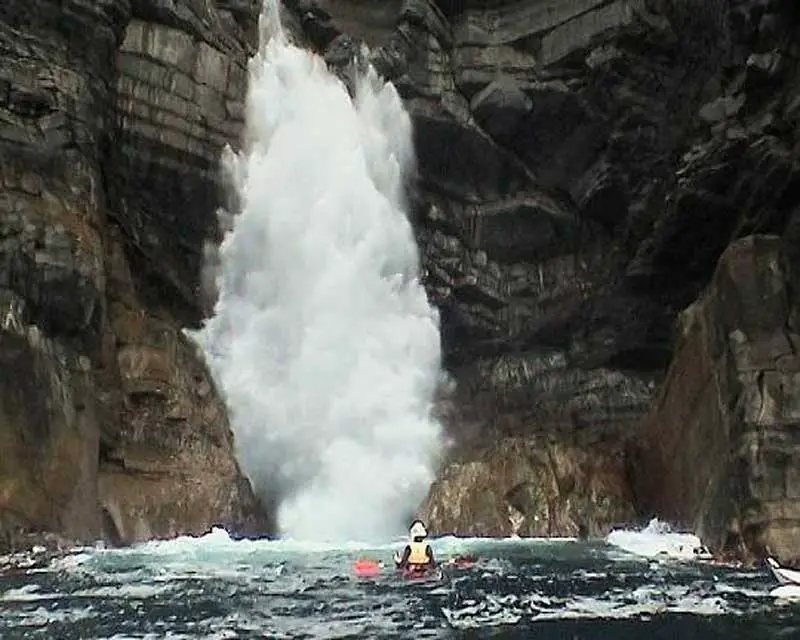
DeWitt Island blowhole