|
|
 |
|
INDEX
WHO DID DISCOVER AUSTRALIA?
COLONIAL EXPLORATION
|
Historical Places: Dirk Hartog Island, WA Located on the extreme north west corner of Australia, Dirk Hartog Island is situated between Shark Bay and the Indian Ocean. Though an isolated location, it is a significance corner in Australia's history in that it was here that two Dutchmen left pewter plates recording of their visits in 1616 and 1696; two French explorers fell out in 1801 over the ethics of removing the plates and taking them back to France; and 29 years earlier another Frenchman had claimed the place for France, leaving a bottle recording the event. It was to remain buried in the sand of Turtle Bay until 1988 when it was recovered by an expedition of the WA Maritime Museum. Dirk Hartog - 1616 On its second voyage to the East Indies, the Dutch trading vessel Eendracht, flying the Dutch East india Company flag, set sail with a fleet of 10 other ships on 23rd January, 1616 from Holland. However, the 700 hundred tonne vessel became separated from the rest of the fleet in a storm near the Cape of Good Hope and continued the voyage alone.
Hartogs remained in the area for two days, exploring the islands before continuing his journey, charting the coast to North West Cape at which point he left the coast and turned for Batavia. The name 'Eendracht's Land' was given to this stretch of coastline and it was known by that name until colonisation of Australia in the 19th Century. The plate left by Hartogs remained on the island until 1697 when a member of Vlamingh's crew found it half buried in sand. Vlamingh replaced it with one of his own recording both visits. He took Hartogs' plate back to Holland with him, where it remains to this day. Willem de Vlamingh - 1697
On 23 August, 1695 he was back in Amsterdam and was nominated for the responsible task of mounting an expedition to search for the Ridderschap van Holland. On 11 July, 1693, the capital ship, Ridderschap van Holland, had departed from the province of Zeeland, in the Netherlands, for the long trip to Batavia. Early in 1694 it had reached Cape of Good Hope but after sailing from there, she had disappeared with 325 passengers and crew - and was never heard from again. The search for the Vergulde Draeck, lost in 1656, had not been a great success but in spite of this the Board of the VOC resolved on November 1695 to give their accord to a new expedition to search for either or both of these ships. The expedition, which was to leave from Batavia, was also to, once and for all, chart the whole west coast. The plan was to retrace the Ridderschap of Holland's route. Three ships, one of which was newly built, sailed under the command of Willem de Vlamingh in May 1996 from Amsterdam. On the way the island of Tristan da Cuhna, in the Atlantic Ocean, was to be charted. The new ship, the flagship of the Commander, Willem de Vlamingh, was named Geelvinck after Joan Geelvinck, member of the Board. The Geelvinck would be accompanied by the Nijptang, with Gerrit Collaert as Skipper, and the Wezeltje, with Laurens Theunisz Zeeman as Skipper. At the Cape the ships' stores were replenished. On 27 October 1696 they started on their voyage to the East. A month later, the Southland was reached. They sailed north, stopping to explore an island which they named Rottnest (Rat's Nest) because of the rat-like animals (quokkas) found upon it. During the exploration of the island they found some wreckage and a piece of timber containing nails indicating that a ship had been wrecked. They considered it not impossible that the timber came from the Vergulde Draeck. A full expedition involving 86 men were sent ashore to explore the mainland, at which time they became the first Europeans to explore the Swan River (right) where Perth now stands. Keeping close to the coast, when the weather allowed, a number of landings were made and the coastline carefully recorded. On 30 January 1697, de Vlamingh sighted another island which he thought to be Dirk Hartog's island. The Geelvinck and Nijptang were sent ahead to circumnavigate the island and find a good anchorage. In the meantime, de Vlamingh did his own exploring. On 3 February, both boats returned. The First Mate reported a startling discovery. When he had climbed a hill to get a better view, he had found a pole with a pewter plate half hidden in the sand. The writings on it stated that it had been left behind by Dirck Hartogh in 1616. It was now certain that de Vlamingh had landed on Dirk Hartog's island and the next day the ships sailed into a sheltered lagoon. From here they spent nine days exploring the surroundings and making accurate charts. This was not entirely without danger for on 7 February one of the boats capsized because of a sudden gust of wind and the ship's carpenter drowned. For the rest, the island did not reveal much. It was uninhabited and the home of many seabirds and turtles.
William Dampier, 1699 On a voyage of discovery, William Dampier arrived here on 17th August 1699 aboard the HMS Roebuck. He anchored his ship between Dirk Hartog Island and Peron Peninsula and noticed the abundance of sharks at this location. It was Dampier who named the area "Shark's Bay" and he also became the first Englishman to walk on Australian soil. Dampier's cook, Goodmin, died whilst in Shark Bay and is the first known European buried in Australia. Dampier and his crew spent 7 days in the area. In this time they could not locate fresh water but were able to stock up with food and wood. Dampier made extensive observations of the plants, animals and geography of the area. He was the first to make botanical collections in Australia and the genus Dampiera &endash; a genus of blue flowering plants that occur extensively in WA &endash; was named in his honor. Dampier also wrote descriptions of the animals he encountered including the first description of a kangaroo. Some Australian animals would have seemed rather strange to him, for he described the kangaroo as "…a sort of racoons…" and the bobtail skink "…speckled black an yellow like toads and had scales or knobs on their backs like those of crocodiles..at the rump, instead of the Tail there, they had a stump of a ^ail, which appear'd like another Head; but not really such being without Mouth or Eyes…" The HMS Roebuck sank in the Atlantic Ocean en route home to England but Dampier managed to salvage his journals and some specimens from which he wrote "A Voyage to New Holland." François-Alesno de St Allouarn - 1772 In 1772, an expedition led by Yves-Joseph de Kerguelen-Tremarec (right) left Ile de France (Mauritius) in command of two ships, Fortune and Gros-Ventre, having been commissioned by King Louis XV to discover the Southern Continent Frenchman Jean Binot Paulmier De Gonneville claimed to have visited in 1504 for France. The expedition comprised the Fortune, captained by Kerguelen, and the Gros Ventre, under the command of François-Alesno de St Allouarn. Kerguelen firmly believed that a massive continent had to exist on the southern hemisphere, just as there was on the northern hemisphere. When he discovered the Fortune Islands on 12 February, 1772, which he named after his ship, he believed he had all but found it. He publicly gave 20 écus (as he had promised) to the sailor who had first discovered land, and promised double that amount to the one who would first see the continent, certain that a sighting would be made by noon the next day. On the morrow, he erroneously believed he had found 'the continent'; Ensign de Boisguehenneuc, of Gros-Ventre, landed on the southwestern coast of Grande-Terre in a bay still named Gros-Ventre Cove on Kerguelen Island (right) and claimed it in the name of Louis XV. Kerguelen himself, aboard Fortune, could not approach due to the perennial bad weather; on 17th February, he made for Mauritius then France, without notifying Gros-Ventre. A bottle containing an account of the visit had been left on the island. It was discovered by James Cook four years later upon his visit to the islands. Meanwhile, St Allouarn on Gros-Ventre was unable to locate the Fortune which had returned to Mauritius after the ships had become separated. Assuming Kerguelen would have continued on in search of the mainland, St Allouarn did the same, continuing north-westwards in the Gros Ventre in search of the expedition leader. The Gros Ventre approached the Western Australian coast a little to the east of Cape Leeuwin on 16 March 1772. By fortune St. Allouarn had struck the coast at the only safe anchorage in the region. Flinders Bay is tucked behind Cape Leeuwin. The Gros Ventre anchored in Flinders Bay about three miles from the shore.
The Gros Ventre left the area on 9 April, 1772, sailing as far north as Rosemary Island before leaving the Australian coast for Timor, Batavia and Mauritius. St Allouarn and de Mingot both died soon after their arrival in Mauritius. The rest of the crew were left to make their own way back to France. Because of the deaths of St Allouarn and de Mingot and the dispersion of their crew, the expedition had disbanded before returning to France therefore the results of the expedition were not widely made known or acknowledged. News of St Allouarn's discovery and his claim of the Southland in the name of France became lost in the commotion over Kerguelen's alleged deception and though the Gros Ventre's journal was tabled, the act of possession was never followed up.
Nicolas Baudin, 1801 The French naval vessels Geographe and Naturaliste, on a scientific expedition led by Nicolas Baudin, arrived in Shark Bay first in 1801 and then again in 1803. The ships had been specially prepared for the venture. Most of the guns were removed to make room for the 22 scientists, their equipment and the specimens they were to collect. This expedition spent 70 days in Shark Bay and during this time make discoveries that contributed significantly to the scientific knowledge of this area and the whole of Australia. They also gave names to many geographical features in the bay. In 1801 a party from the Naturaliste, commanded by Captain Emmanuel Hamelin landed at Cape Inscription and discovered de Vlamingh's plate half buried in the sand. Hamelin had the plate re-affixed to another post made by the ship's carpenter and erected where it had been found. Hamelin also had a plate of his own erected here to commemorate Baudin's expedition. Louis de Freycinet 1818 In 1818 Louis de Freycinet, a French explorer who had been a member of Baudin's expedition, returned to Shark Bay on the Uranie as part of a world scientific voyage. On board was his wife Rose who had stowed away to join her husband on the voyage. She records in her journal that de Vlamingh's plate was found with some difficulty and delivered to France for safe keeping. It is assumed that Hamelin's plate was also removed at this time, but this is not certain. Members of the Uranie expedition established a temporary camp at Cape Lesueur on Peron Peninsula. On his departure, Freycinet left a number of gifts on the shore in the hope that they would be discovered by and of use to the Aborigines. These items included looking glasses, scissors, iron hoops and knives. While surveying the coast in 1821-22, Phillip Parker King searched in vain for the plates but found only Hamelin's post, into which he inscribed his name. Dirk Hartog's plate is now in Amsterdam's Rijsmuseum. De Vlamingh's plate and the post King inscribed are in the WA Maritime Museum in Perth. Henry M. Denham, 1858 Captain Henry Mangles Denham charted the Bay's waters in 1858. It is believed that Captain Denham had the words "Denham; Herald 1858" chipped into a 20 metre high limestone cliff at Eagle Bluff. The section of the rock bearing this inscription is now in Denham's Pioneer Park. |

 Its skipper, Dirk Hartog, appears to be one of the first Dutch skippers to test a new route to the East Indies which took full use of the westerlies to the east of the Cape of Good Hope before turning north, rather than following the African Coast. Much to his surprise Hartog sighted the Southland on his journey. Though the ship's log is lost, a letter from him to a friend records that he saw several uninhabited islands behind which was a vast mainland. He anchored in a bay near one of these islands (later to be named in his honour) on 25th October, 1616 and recorded his visit on a flattened pewter plate which he nailed to a post on the cliff of Cape Inscription (right). The translation of the inscription reads:
 Eighty-one years later in 1697, the Dutch captain, Willem de Vlamingh landed on the Island and discovered Hartog's plate. He replaced it with one of his own which included Hartog's inscription and returned the original plate to the Dutch East India Company. De Vlamingh was born on the island of East-Vlieland in the Netherlands. Because part of the Vlielanders livelihood was whaling, his early seafaring experience had been on whale boats. He married in 1668 and settled in Amsterdam and its seafaring world. In 1688, he joined the Dutch east India Company and on 26 November of that year he made his first trip to Batavia.
 On 11 February 1697, the task was at an end and de Vlamingh made ready to sail. Before he departed however, he gave instructions to inscribe a pewter plate, like Dirck Hartog had done in 1616, and had it nailed to the pole at exactly the same spot. He took Hartogs' plate with him. The location, named Cape Inscription, is today marked by a monument (right). They weighed anchor on the 12th and sailed northwards. He remained as close to land as possible until Latitude 20°S. On 21 February, he veered away from the Southland and commenced the last leg of his journey to Batavia. Vlamingh's report of the trip was sent on to Holland as well as the eleven drawings done by Victor Victorszoon, Dirck Hartogh's plate, a box with sea shells, fruits and vegetation which de Vlamingh had gathered and a bottle of oil, extracted from the exquisite smelling wood found on Rottenest were also sent. Nicolaas Witsen, the instigator of the expedition, was very disappointed with the result and at first blamed Willem de Vlamingh but later his mood mellowed somewhat. Thanks to de Vlamingh's exact observations, it was possible for the VOC cartographer in Amsterdam, Isaac de Graaff, to draw a detailed map of the West Australian coast from latitude 20°S to 32°S. His findings for once and for all established that for the VOC there was no profit to be made on the West Australian coast. The Dutch would not carry out any further exploration. Dirck Hartogh's plate, which de Vlamingh took with him, is now housed in the Rijksmuseum in Amsterdam. The plate which de Vlamingh left in its place on Dirk Hartog Island is now on display in the West Australian Maritime Museum in Fremantle.
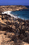 He then sailed north up the coast to Shark Bay. On 29 March, he anchored off Turtle Bay at the north end of Dirk Hartog Island in Shark Bay (right). St Allouarn sent a boat with an officer to reconnoitre the land, accompanied by the boat's crew and five soldiers. being too ill himself to leave the vessel. His second in command, Lieut. M. de Mingot, took possession of all the land to the north and east of Shark Bay. A flag was raised to mark the occasion and de Mingot placed under a bush a bottle containing two six-franc coins and an Act of Possession, claiming possession of the west coast of New Holland for the King of France. The ship's log refers to this Bay as the 'Baie de Prise de Possession' (the Bay of Taking of Possession). It is not known whether or not St Allouarn knew the significance of the location, it being near where Dutchmen Dirk Hartog and Willem de Vlamingh had visited and left pewter plates recording their visits 156 and 75 years earlier. Indications are he did not as the two pewter plates of Valmingh and Hartog were left undisturbed.
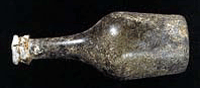 In January 1988, a French coin was found at Turtle Bay (marked Dirk Hartog Bay on Freycinet's map below) on Dirk Hartog Island, Shark Bay, by an archealogical expedition. This coin is thought to have been one of the coins left by de Mingot. Three months later, a Maritime Museum team located what is believed to be the annexation bottle (right). It contained a silver coin - a French écu with the date 1767 - which was firmly held in the top of the capsule but no annexation document. Wax-eating moths appear to have entered the bottle and possibly destroyed the document, if indeed it was st allouarn's bottle. The site where the bottle and coins were found is now protected under the Maritime Archaeology Act as one of Western Australia's most important European landing places.