
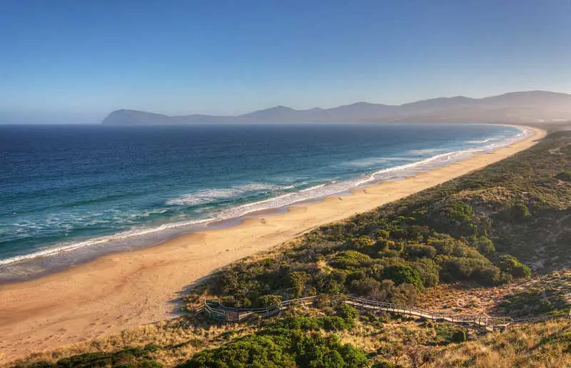
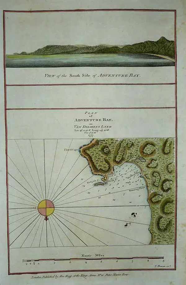
Adventure Bay, Tasmania
Bruny Island in general and Adventure Bay in particular is steeped in the rich history of Australia's early explorers, its convict past and the whaling industry which flourished in the early days. Long used by the Nuenonne band of the South East Tribe of Aborigines Adventure Bay was first sighted by Europeans when Abel Tasman arrived in November 1642. His ships, the Zeehaen and Heenskerck, briefly entered Adventure Bay but fierce storms prevented him from landing. Adventure Bay is named after HMS Adventure. Captain Tobias Furneaux was in command of HMS Adventure when he visited and named the bay in March 1777.
 On 2 June 1639, Dutch navigator Abel Tasman was dispatched by Antonio van Diemen, Governor-General of the Dutch East Indies, on a voyage to the north-western Pacific, in what was to be an unsuccessful search for certain 'Islands of gold and silver', east of Japan, which, as we now know, don't exist. In 1642 he set out on the first of his two 'South Land' expeditions. The expedition left Batavia on 14 August 1642 with two vessels, the Heemskerk with sixty men and the Zeehaan with fifty men on board. They first called at Mauritius, where they stayed for a month long repair to both ships.
Tasman decided to sail his ships east along the south coast beyond Cape Leeuwin. He did this and reached the islands of St Peter and St Francis on the South Australian coast, then travelled further south, sighting Tasmania on 24 November 1642. Tasman named the island after the governor of The Dutch East Indies, Antonio van Diemen. The first two mountains they sighted were named Mount Zeehan and Mount Heemskirk, after their ships. Variable weather made exploration of the eastern coast difficult. Seeking shelter in a storm, Tasman put into a cove he called Storm Bay. In actual fact, he took shelter in what is known today as Adventure Bay on Bruny Island. A later explorer, Furneaux, misread Tasman's charts and called Tasman's Storm Bay Adventure Bay and gave the name Storm Bay to a larger bay nearby.
On 1 December the storm abated, allowing the ships to anchor at Green Island and put ashore for supplies at what is now known as Blackman's Bay (3km north of Bruny Island beyond Piersons Point). On the following day Tasman intended to go ashore and claim the land for Holland, but his boat crew were prevented from landing due to heavy seas. Instead, he got the ship's carpenter, Pieter Jacobszoon, to swim ashore and tie a Dutch flag to a stake on the shore, and claim possession. This having been done without mishap, Tasman moved his ships on, following the east coast of Tasmania. When the shore fell away to the northwest (Bass Strait) and the weather was coming in directly from the north, Tasman decided to quit this island and continue east, sailing on to the south island of New Zealand.
Names recalling Tasman's visit
Van Diemen's Land: Anthonie Van Diemen, Governor of the Dutch East Indies
Storm Bay: storm encountered there on 29 November 1642 (the actual location was today's Encounter Bay)
Tasman Island: Abel Tasman
Frederick Henry Bay: Frederick Henrijk, a councillor of the Dutch East India Company
Boreel Head: Pieter Boreel, Councillor, Dutch East India Company.

Memorial at Adventure Bay to the explorers who visited there
British captain Tobias Furneaux was the commander of Adventure during James Cook's second voyage to the Pacific. Near Van Diemen's Land his vessel became separated from Cook in a fog. Whilst Cook sailed on to New Zealand, Furneaux travelled further north and sighted a group of islands off the South West Cape of Tasmania on 9 March 1773. James Cook was to later name the islands after Furneaux. On a four day trek following the path taken by Dutchman Abel Tasman 130 years before, Furneaux then visited a number of locations including Adventure Bay and Bruny Island, charting the coast as he went.
Others among Furneaux's crew spotted evidence of what they believed were small deer but were more likely kangaroos. Furneaux also noted signs of an Aboriginal settlement in the form of "several huts or wigwams on shore, with several bags of grass in which they carry their shellfish." - but the branches of which the huts were made were "split and torn" and there was "not the least appearance of any people."
Names recalling Furneaux's visit
Adventure Bay: HMS Adventure
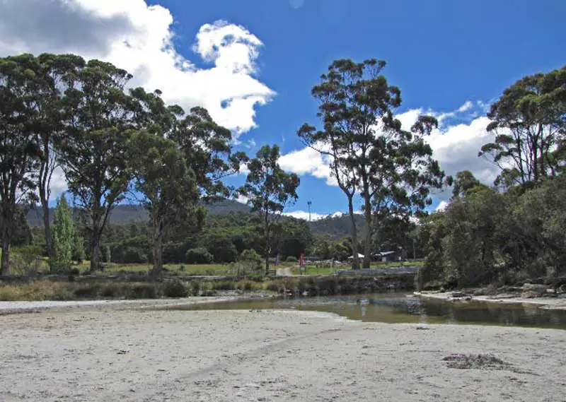
Resolution Creek, Adventure Bay, Tasmania, where Cook and others watered his ships
Four years after Furneaux's visit during James Cook's third voyage to the Pacific (1775-1780) Cook's ships the Resolution and Discovery anchored in the Bay to restock supplies of food, water and wood during a 4 day sojourn. Cook's contact with the Aborigines who lived on the island was amicable. There is a stone plaque marking the significance of Resolution Creek at Two Tree Point, where the crew of the Resolution collected water on 26th January 1777.
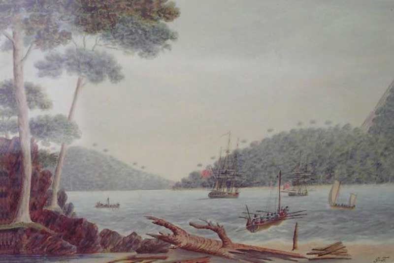
In Adventure Bay, Van Diemen's Land. Painted by Lieut. G. Tobin.
During this time a member of the ships crew, Lieutenant George Tobin, produced a series of watercolours of the place. One of these pictures, 'In Adventure Bay, Van Diemen's Land', shows a point with two trees on it. These trees look like younger versions of the two trees that currently stand there. It has not been established conclusively that the two trees are those painted by Tobin. However, the two existing trees and their setting on the point correspond closely with the historical imagery of this early landing site, as depicted by Tobin. This area has changed little since 1792, and is evocative of the landscape that would have been experienced by 18th century European visitors to Tasmania.
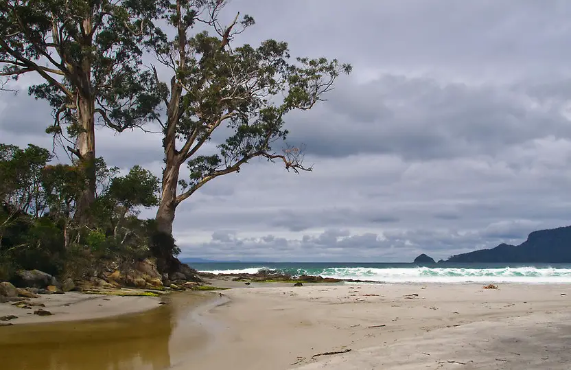
Two Tree Point today
Aboard the Resolution was William Bligh, who was later to suffer the humiliation of a mutiny aboard the Bounty during an expedition to transport breadfruit plants from Tahiti to the West Indies. Bligh visited again in 1788 and planted a number of fruit trees at East Cove. It was from here that Bligh departed on his ill fated voyage to Tahiti, and his infamous the mutiny. After the Bounty voyage, he led another expedition to transplant breadfruit plants from Tahiti to the West Indies. Bligh set sail aboard the brig Assistant from Portsmouth in August 1791, returning to Adventure Bay, Tasmania, in February 1792. He found an Apple was still growing on Australia's and the Apple Isle's first apple tree. Bligh's Midshipman was Matthew Flinders, who set foot on Australian soil for the first time at Adventure Bay. One of the earliest echidna specimens was collected in 1792 at Adventure Bay. Captain Bligh both drew and described this peculiar animal.
Bligh's chart of Adventure Bay
In September 1791, the French Government decided to send an expedition in search of La Perouse, a French explorer who had not been heard of since leaving Botany Bay in 1788. Bruni D'Entrecasteaux was selected to command this expedition. He was given a frigate, La Recherche (500 tons), with d'Hesmity-d'Auribeau as his second in command and de Rossel among the other officers. A similar ship, L'Esperance, was placed under Huon de Kermadec, with de Trobriand as his second in command. A distinguished hydrographical engineer, C.F. Beautemps-Beaupre, was the hydrographer to the expedition.
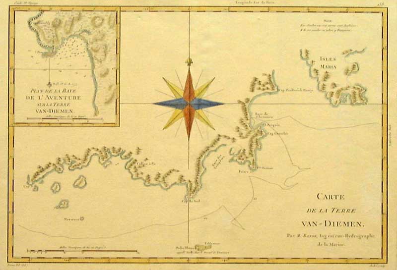
French chart of Van Diemen's Land and Adventure Bay (inset)
The expedition left Brest on 28 September 1791. The plan of the voyage was to proceed to New Holland (Australia), to sight Cape Leeuwin, then hug the shore closely all the way to Van Diemen's Land (Tasmania), inspect every possible harbour in a rowing boat, and then sail for the Friendly Islands (Tonga) via the northern cape of New Zealand. He was next to follow in La Perouse's planned tracks in the Pacific. Land was sighted in April 1792. The ships anchored in a harbour, which he named Recherche Bay, and for the next five weeks, the Frenchmen carried out careful boat explorations that revealed in detail the beautiful waterways and estuaries in the area. The party then moved on to the coast of Tasmania, charting as they went. While surveying the coasts, Beautemps-Beaupre, with Lieutenant Cretin, surveyed Adventure Bay and discovered Bruni Island and the channel which separated it from the mainland. On 16 May, d'Entrecasteaux commenced to sail the ships through the channel and this accomplished by the 28th. Port Esperance, the Huon River, and other features were discovered, named and charted, the admiral's names being given to the channel and the large island separated by it from the mainland. On 28 May 1792, the ships left Tasmania and sailed into the Pacific to search for La Perouse. The spelling of Bruni Island was changed to Bruny Island in 1918.
Names recalling d'Entrecasteaux's visit
Huon River, Port Huon, Houn Point, Huonville: Huon Kermadec, commander of the Esperance
Bruny Island, D'Entrecasteaux Channel: Bruni D'Entrecasteaux
Recherche Bay: frigate La Recherche
Cape Delasorte: It is generally believed it is wrongly placed on the charts of to-day. The evidence is clear that the French commander gave the name to the eastern point (now charted as Point Kelly), and not to the point on the river side of the Island. The name means 'of the same kind'. Port Cygnet: swans and cygnets seen there
Cape Direction: bearings were taken here
Betsey Island: previously named Willaunez Island after one of his officers.
Partridge Isld: named Ile Aux Perdix after crew member Jean Perdix, L'Esperance.
The Neck: named St Aignon Isthmus after a member of his expedition who waded ashore near here naked after the accidental beaching of his boat.
Tasman Head: named Point La Billiardiere after Jeane de La Billiardiere, who also sailed with Baudin, 1801-03.
Cape Bruny: named after expedition leader, Bruni D'Entrecasteaux. Originally spelt Bruni, the name was later changed to Cape Bruny.
Cape Deslacs: Hippolyte Deslacs, seaman of Recherche
The Bligh Museum of Pacific Exploration on Bruny Island contains an amazing collection of documents, relics and artefacts from this era. Its collection includes a remnant of a tree where Cook carved 'Cook 26th January 1777', a globe of the world which dates to 1799 and some interesting memorabilia relating the Captain Bligh.
Adventure Bay became a centre of the whaling industry with whalers using the Bay as early as 1804. By 1829 the Bay supported some 80 to 90 men, two sloops and up to twenty whale boats. A walk from East Cove to Grass Point will take you past numerous site of interest and at Grass Tree Point you will see the Ruins of old whalers cottages. The Agricultural and Timber industries provided further employment and even sandstone and coal mining was undertaken on South Bruny. The Melbourne GPO and Houses of Parliament were built from Sandstone mined at Ventenat Point on South Bruny.
Trugannini one of Australia's most famous Aboriginals was a member of the Nuenonne band and was born on Bruny Island in 1812 the daughter of the chief Mangana. Exhibits from all of these periods and pictorial folders depicting the complete history of Bruny Island from aboriginal times to the present can be found at "The History Room" at Alonnah.
Adventure Bay is named after HMS Adventure. Captain Tobias Furneaux was in command of HMS Adventure when he visited Adventure Bay in March 1777.
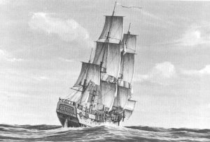
The Admiralty purchased two near new Whitby-built colliers for Cook's second voyage of discovery, the Marquis of Granby, 402 tons, and the Marquis of Rockingham, 340 tons. They were comissioned under the names of Drake and Raleigh which subsequently became the Resolution and Adventure.
Sir Joseph Banks had suggested a forty-gun ship or an East India Company ship, but the Admiralty had no hesitation in following Cook's recommendations. The ships had a larger hold than the other types and more space between decks where the men were berthed. This allowed for a greater amount of fresh air and light and also less damp conditions. Cook supervised the fitting out of the ships with the help of Lord Sandwich, First Lord of the Admiralty.
The Adventure, which cost the Navy £2,103, was placed under the command of Captain Tobias Furneaux, a Devonshireman who had been Second Lieutenant under Wallis on the Dolphin. Furneaux was an excellent seaman but unfamiliar with Whitby ships. After refitting, the Adventure sailed at 335 tons with a compliment of 81 men and one civilian. The Board of Longitude sent two astronomers on the second voyage and William Bayly sailed with Furneaux. The Adventure was a smaller edition of the Resolution, a good looking ship but she did not achieve the fame of Cook's choice.
By mid-December 1772 the two ships had reached the Antarctic waters. The first crossing of the Antarctic circle occurred in January 1773. They became separated in a heavy fog when only about 75 miles from Enderby Land but did not know that land was close. By prearrangement the future rendevouz was to be Queen Charlotte Sound, New Zealand. Furneaux visited Tasman's Van Diemens Land (Tasmania) and named Adventure Bay. He concluded there was no strait between Van Diemens Land and New Holland. However, astronomer Bayly insisted that there were coastal islands and a strait. Bayly was proven correct by the ship's surgeon, George Bass who sailed through the strait which bears his name - some 20 years later.
Cook met up with Furneaux at Queen Charlotte Sound on 18 May 1773 where he found that his strict anti-scorbutic diets had not been followed. Half of Furneaux's men had contracted scurvy and one crew member subsequently died. By a quirk of fate it was the ship's Cook, Mortimer Mahoney, known as Murduck Mahoney. Passing on to Tahiti, the Adventure was nearly wrecked when swept onto some reefs. She lost three anchors before getting clear.
After discovering islands named by Tasman, the Resolution and Adventure returned to New Zealand where they once again became separated near Cook Strait in a gale. Nine of Furneaux's men were murdered by Maoris at Queen Charlotte Sound and he returned to England twelve months ahead of Cook.
Furneaux's Adventure returned to her Whitby owners and sailed on for a further 35 years. In 1811 she was in the St. Lawrence River, the scene of Cook's magnificent charting work, but Cook was not there to guide her through the treacherous reaches. The great river was determined to perpetuate the memory of Cook and claimed the Adventure for all time when she was wrecked there.
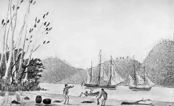
The "Providence" and "Assistant" at Anchor in Adventure Bay. Drawn by Lieut. G. Tobin, 1792.
