The Bay of Fires, a beautiful piece of wilderness coastline in the
north-east corner of Tasmania, stretches from Eddystone Point in the
north to Binalong Bay in the south. Characterised by stunning blue
water, fishing lagoons, spotless white sandy beaches and orange lichen
covered granite boulders, the area is often mentioned internationally
in lists of the world’s top beaches.
A place of tranquil beauty and one of Tasmania’s most popular
tourist destinations, this 29-kilometre ribbon of sea, surf and sand is
renowned for its island beach culture, cosy cottages and nature walks,
not to mention its natural beauty. The bay’s unusual name was
given to the area by Captain Tobias Furneaux, in 1773, when he saw the
smoke from the fires of the local Kunnara Kuna tribe. This led him to
believe that the country was densely populated. Abundant evidence of
this occupation by Aboriginal people can be seen along the coast today.
Where Is it?
The Bay of Fires is located in the north-east corner of Tasmania. It stretches from Eddystone Point in the north to Binalong Bay in the south.
The northern section of the Bay, from north of the outlet of Ansons
Bay to Eddystone Point lies within the Mt. William National Park.
The middle section of the Bay of Fires lies in the vicinity of Ansons
Bay. It can be accessed via Policemans Point or the northern shore of
Ansons Bay, however be aware that it is not possible to cross the
outlet of Ansons Bay.
The southern section of The Bay of Fires is in the Bay of Fires
Conservation Area, situated along a 13 km stretch of coast between
Binalong Bay and The Gardens.

Surrounding Area

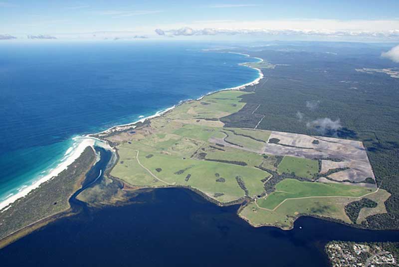
Binalong Bay
10 minutes north of St Helens is the little community of Binalong Bay, which marks the beginning of the Bay of Fires. Noted for its rock and surf fishing, it is here that visitors first see the bay’s large expanse of untouched coastline, lined with clean, white beaches punctuated by picturesque granite outcrops covered in orange lichen. With an array of accommodation, fishing and diving facilities, and a general store and cafe, Binalong Bay is an idyllic location for those seeking a ‘holiday in heaven’ and an ideal starting point for walks along the coastline.
 The Gardens
The Gardens is a picturesque area was named by Lady Jane Franklin, the wife of Governor John Franklin, who spent some time in the region. If your visit to the area is a brief one, the drive along the coast to The Gardens from Binalong Bay is recommended. Along the way are Jenneret Beach, Swimcart Beach, Cosy Corner and Sloop Point, all of which give access to the beach; some have camping facilities. Cosy Corner and Sloop Point have some great photo opportunities.
 Ansons Bay
The small fishing village of Ansons Bay has been famous since its beginning as a premier bream fishing resort. There are approximately 200 houses scattered along the shores of the Bay, built amongst the natural forest. Some people reside permanently in Ansons Bay but many more visit the community for holidays and weekends. There is only one shop in the area. Ansons Bay is the closest settlement to the historic Eddystone Point Lighthouse – circa 1889. Nearby is the beautiful Mt. William National Park. Extreme care should be taken to avoid wildlife on the roads through the area, which are unsealed.
Surrounding Area

Mount William National Park
Accessed from Ansons Bay or Gladstone, Mt. William National Park was
established in the 1970s, in part to provide a refuge for the Forester
kangaroo, a Tasmanian subspecies of eastern grey kangaroo which was in
grave danger of extinction at the time.
Like so much of Tasmania’s east coast, the geology of Mt. William
is dominated by granite. Due to its high quartz content, granite breaks
down into a very pure sand which has formed beautiful white beaches
that are one of the features of the park.
There is a large population of marsupials – wombats, Forester
kangaroos, Tasmanian pademelons and wallabies, particularly along
Forester Drive. With a rich diversity of coastal vegetation boasting
spring flowering, the park is an important area for the conservation of
Tasmania’s coastal heathlands and dry sclerophyll communities or
plants. Heath is found on poorer soils, such as those here, which
result from weathered granite and wind blown sand.

Eddystone Point
Called Larapuna in the local Aboriginal language, Eddystone is part
of the traditional territory of Tasmanian Aborigines. Aborigines have
re-occupied Eddystone Point since 1999 when the Tasmanian Government
agreed in principle to the return of Eddystone Point and Mt. William
National Park. The point is essentially one huge midden – and
there are over ninety middens, – nearly sixty artefact sites and
some burial in Mt. William National Park, which surrounds the point.
The striking pink granite tower of the Eddystone Point lighthouse was
built on a point that juts out into the sea in 1889 in response to many
north bound ships being wrecked by coming in too close to the northeast
coast of Tasmania. The light was serviced by sea and over the years the
landing areas took a battering with jetties having to be rebuilt
several times. The lighthouse is in the Mount William National Park. It
can be reached by unsealed roads of a fair condition from St Helens or
Gladstone (32 km).