
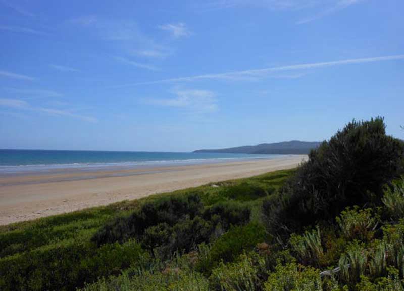
Port Sorell is a pretty coastal town featuring sheltered beaches, good fishing, orange lichen-covered rocks and foreshore reserves for camping and picnics. Nearby Narawntapu National Park is a place of great serenity and a haven for wildlife, which abounds on its grassy plains and in its marshes and heathlands. Shops and services are located at neighbouring Hawley Beach.
Where Is it?
Port Sorell is 254 km north of Hobart, 79 km north west of Launceston, 20 km east of Devonport, on the Rubicon River estuary.
Visitor Centre
Club Drive, Shearwater. Ph (03) 6428 7920

Things To See And Do
Markets
NORTHDOWN MARKET
Northdown Anglican Church Hall, Main Rd, Port Sorell
Trading: 2nd Saturday of the Month – 9:30am – 2pm
Type: General. Phone: (03) 6428 7507

Around Port Sorell
Much of the activities around Port Sorell revolve around water,
partularly the Rubicon Estuary. Diving, boating, fishing from the beach
or floating pontoon, water skiing and sea kayaking are all popular
activities here. The town’s boat ramp is the busiest on the
north-west coast. The beach, with its orange lichen-covered
granite rocks, is both beautiful to look at and ideal for swimming. It
is also known for its minute red sand crabs, Hooded Plovers and good
fishing.
At low tide it is possible to walk to Penguin Island and Rabbit Island
the latter a hideout for bushrangers in the mid-1800s.
Narawntapu National Park
Just across the Rubicon River is Narawntapu National Park, abounding in Forester kangaroos, wallabies, wombats and even Tasmanian devils on its grassy plains and heathlands. They are relatively comfortable in the presence of people and will often allow you to approach them for close observation. At dusk, you can catch sight of little penguins scampering up the beach at Point Sorell. The western part of the park is in an ideal location to be combined with a tour of the vineyards of Tasmania’s premier wine-growing region, the Tamar Valley.

Walking Trails

Stroll on the coastal and bush reserve tracks and be inspired by the natural beauty. A brochure detailing these self guided walks is available from the Latrobe and Port Sorell Visitor Information Centre.
Aub luck reserve
Location: Joyce Street, Hawley Beach. Enjoy a gentle stroll through the well maintained Aub Luck Reserve to enjoy the natural bushland amongst the casuarinas and blackwoods, home to various Tasmanian Native Animals: Bennett’s Wallabies, Pademelon’s, Eastern Barred and Brown Bandicoots, Wombats and a plethora of various birdlife.
Coastal Walk
From the northern end of Hawley Beach near Hawley House to Point Sorell facing into Bass Strait and return (6 kms).
Panatana Rivulet: Location: Access from Rice Street, Port Sorell.
Stroll along the Rivulet’s northern shore from Port Street past
River Road. Return 4 kms. Or stroll along the Rivulet’s
southern shore (Bird Sanctuary) over the footbridge between Darling and
Rice Streets. Return 2 kms.
Rubicon Beach
This walk follows on from the Panatana southern shore walk and ends at Squeaking Point through the Port Sorell Conservation Area, a shoreline Reserve. Return 2 kms.
Estuary Eastern Shoreline
Location: Follow the signs on the Frankford Highway to Narawntapu National Park to access the Franklin River starting point. From 1? kilometres south of The Tongue at the western entrance to south east arm, Franklin River and Sugar Creek to The Tongue and around to Lades Road near The Point there is over four kilometres of shoreline reserve to explore. You will need vehicle access as your starting point is 16-18 kilometres from Port Sorell.
Major Attractions


Surrounding Towns
- Devonport
- Latrobe
- Deloraine
- Beaconsfield
- Westbury
Regional Attractions

Book Vehicle Hire

Book Accommodation

Design by W3Layouts | Content © 2013 Phoenix Group Co. | Sales: phone 1300 753 517, email: [email protected]