
The Tarkine is Tasmania’s largest unprotected wilderness area. It hosts the only wilderness landscape dominated by rainforest in Australia. Its rainforests form the largest continuous tract of rainforest in Australia, they being the largest temperate rainforests in Australia.
There is a rich pioneer/exploring history of the Tarkine region, which was regarded as one of Tasmania’s toughest and most impenetrable regions. Prospecting and Mining was one of the biggest drawcards to the region for early settlers, with tin mining set up at Balfour, Gold at Corinna, and Tin at Waratah also. ‘Prospectors’ often searched the rivers in years between 1850 and 1950 quite unsuccessfully.
Current historical areas include; Balfour (former mining town, now ghost town), Magnet (ghost mining town), Corinna (former gold mining boom town), and Waratah. Emu Bay Railway, regarded as possibly Tasmania’s most spectacular railway, was built nearly a century ago, and winds through spectacular rainforest gorges in the eastern fringes of the Tarkine.
On a global scale, the Tarkine contains one of the world’s most significant remaining tracts of temperate rainforest (second only in size to those in western Canada – British Columbia). Temperate Rainforest is the rarest of the rainforests, and more highly threatened even than tropical and subtropical rainforests. outside of The Tarkine, Temperate Rainforest only remains in fragments in New Zealand, Chile and Western Canada and US. The tall rainforest of the Tarkine exists largely on an extensive basalt plateau which still retains its native vegetation.
The word ‘Tarkine’ comes from one of a number of bands of Aboriginals that lived in the North-West Region. The ‘Tarkiners’ were a group who were based at Sandy Cape (Tarkine Coast).
Where Is it?
The Tarkine Wilderness is a region in North West Tasmania, bound roughly by the Bass Highway to the North, the Pieman River to the South, the Murchison Highway to the East, and the Southern Ocean to the West.
The Tarkiners seasonally travelled throughout the Tarkine region,
travelling as far as 140 km north to the Hunter Islands hunting for
mutton birds and fur seals, and as far as 100 km east to the Surrey
Hills for wallabies and emus.
The word Tarkine was first recorded in the 1800s, by George Augustus
Robinson. In his diaries ‘The Friendly Mission’ which give
an account of several trips made to the North-West to meet and then
remove the North-West Aboriginals, Robinson talks several times about
the Tarkine and the Tarkiners.

Natural Attractions
The Tarkine contains a wide variety of spectacular landscape features, may of which can be explored with relative ease with a 4-wheel drive vehicle.
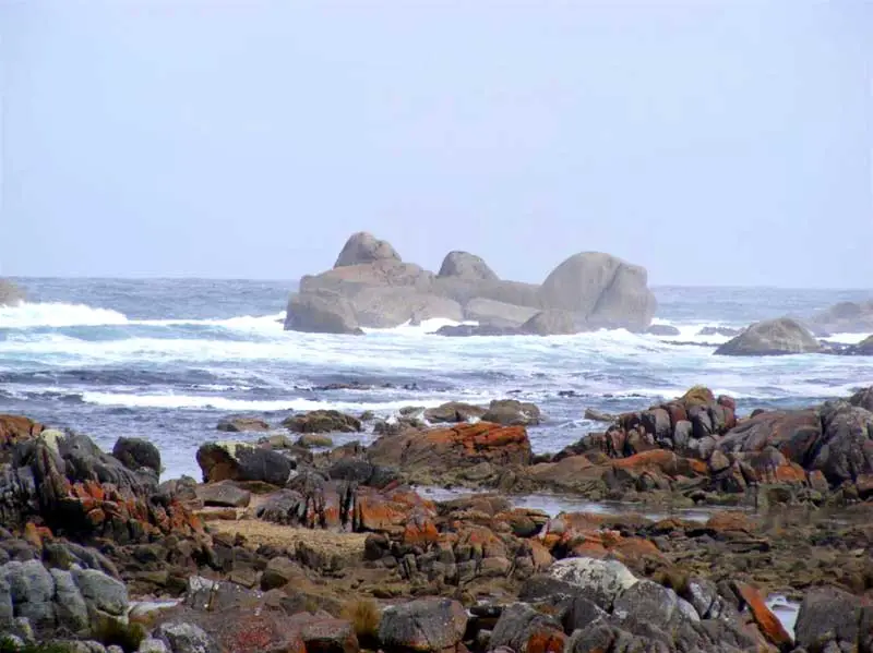
Coastline
Spectacularly wild coastline, battered by the winds of the roaring 40s. The purest air in the world. Huge dunes that stretch inland up to several kilometres. Rocky, jagged coastal stretches. Incredible Granite Tor formations (especially at Conical Rocks south of the Pieman River), extensive long sandy beaches, lagoons, grassy woodland, coastal heathland, marshes and swampland. Sandy cape forms a dominant and spectacular feature of the Tarkine’s coast.

Norfolk Range
Distinctively rises above coastal plateau, to over 700m. Contains a belt of sub-alpine rainforest. This region is blanketed in a tapestry of heath and buttongrass, moorland, pockets of varying forest types, and gorge-like drainage lines.
 Meredith Range
Meredith Range (reaching over 900 metres) is an undulating granite plateau, the largest exposed area of granite in western Tasmania. Affords spectacular views of Cradle Mountain, and the South-West. Pockets and stretches of tall, implicate and sub-alpine rainforest exist amongst the granite pillars and plates of the Meredith Range.
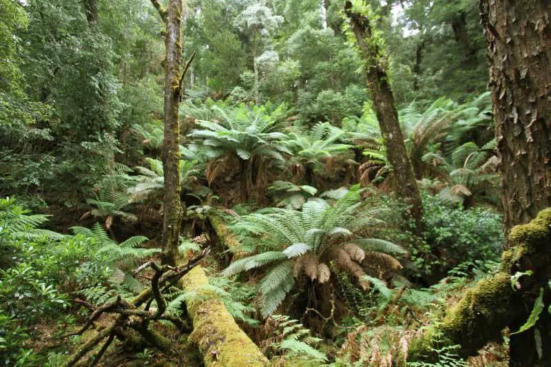 Rainforest
The vastness of Australia’s largest tract of temperate rainforest is impressive, and reaches/covers the Arthur, Pieman, Rapid, Keith, Donaldson and Savage River valleys. The densely rainforested upper Savage River is exceptional due to its deeply incised gorge system.

Natural Attractions

Wild Rivers
The Tarkine hosts Tasmania’s greatest density of wild rivers. The major rivers remain remote and largely inaccessible. These include; Thornton, Lagoon, Pedder, Wild Wave, Interview (coastal), Donaldson, Little Donaldson, Keith, Lyons, Rapid, and Upper Savage (rainforests), Huskisson and Wilson (Southern Tarkine).
 Grand Rivers
The Tarkine contains two of Tasmania’s Grandest Rivers, the
Arthur River (which is the only complete river system in Tasmania that
has no dam), and the Pieman River. The Arthur River is characterized by
steep gorges and rapids, valleys blanketed in rainforest, and stretches
of giant eucalypt forest.
It is fed by the Hellyer, Keith, Lyons, Rapid, and Frankland rivers.
The Pieman River is most famous for its reflections. Like the Gordon,
the Pieman, on a good day, gives spectacular mirror like river
reflections. The section from Corinna to the coast is broad and flat
and is flanked by rainforests, and Tasmania’s most northerly
stands of Huon Pine. The Whyte, Savage and Donaldson rivers feed the
Piemans lower stretches. The Upper Pieman river is dammed, and is fed
by the Tarkine’s Huskisson, Wilson and Stanley rivers.

Waterfalls
There are a number of spectacular known as well as barely known waterfalls within the Tarkine’s rainforests (including Philosopher’s Falls, McGowan’s Falls, lovers Falls).

Cave Systems
The Tarkine contains globally significant magnesite cave systems. They are potentially the most significant if not the only significant system of magnesium cave systems in the world. They include caves, sub-surface cavities, sinkholes, springs, and surface features including gorges and castle-like formations. They are most significant in the upper Lyons River region. There are also a number of small cave features that show evidence of Aboriginal occupation within the Savage River Rainforests.
Major Attractions


Surrounding Towns
- Queenstown
- Strahan
- Trial Harbour
- Granville Harbour
- Rosebery
- Tullah
- Corinna
- Balfour
- Waratah
Regional Attractions

Book Vehicle Hire

Book Accommodation

Design by W3Layouts | Content © 2013 Phoenix Group Co. | Sales: phone 1300 753 517, email: [email protected]