
A must-see destination when cruising the Kimberley coastline in the far north of Western Australia, Bigge Island is famous for its amazing galleries of Aboriginal rock art. Both Gwion Gwion (also known as Bradshaw art) art and Wandjina art is in evidence in the coastal caves of the island. Potentially up to over 50,000 years ago, the Gwion Gwion images are possibly the oldest known to man.
Bigge Island, located off the headlands that lie between York Sound and Montague Sound (of which Bigge Island forms the western limit), is the largest of the islands that comprise the Bonaparte Archipelago. With an area of 178 sq. km, it is the second largest island along the coast of the Kimberley after Augustus Island. It is separated from the mainland by the Scott Strait.
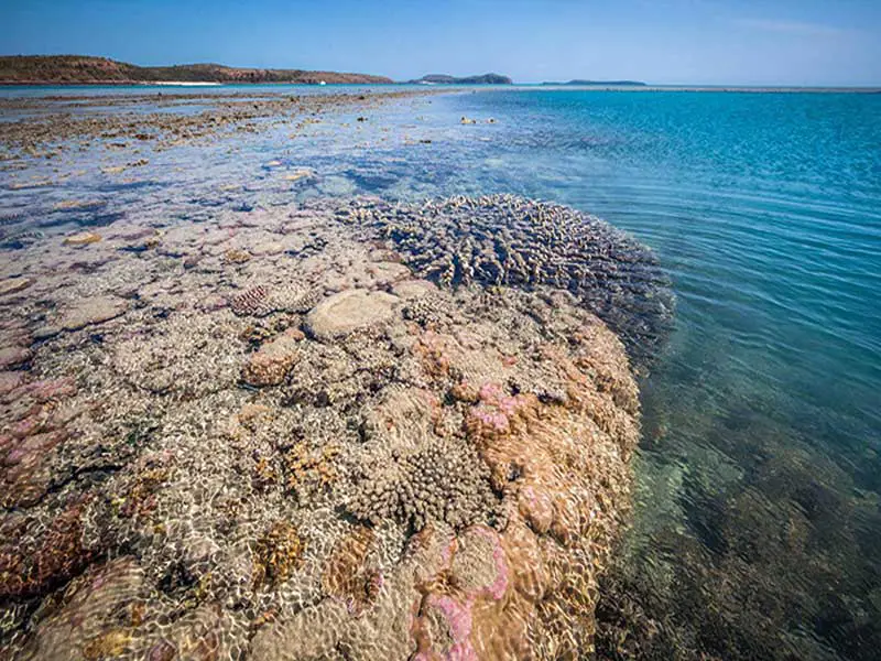
The island has an irregular shape, but is roughly rectangular, measuring 22 km north to south and 11 km across, with the north coast cut deeply by the large Boomerang Bay. It is a rugged formation composed of ancient and highly weathered rocks of whitish to reddish quartz sandstones with patches of darker-coloured dolerites. Much of this is bare rock, with vegetation being confined to valleys, gullies and channels.
The interior is crossed by a network of deep grooves, fissures and joints that can run for considerable distances across the island. The island rises to height of 143 m at Savage Hill on the south coast opposite the Scott Strait. It is populated by the small Monjon rock wallaby and the Northern Quoll.
Where Is It?
Brigge Island is part of the Bonaparte Archipelago, a group of islands off the coast of Western Australia in the Kimberley region. The closest inhabited place is Kalumburu located about 100 kilometres to the east of the island group. The island lies approximately 6 kilometres from the mainland, from which it is separated by Scott Strait. It is located between York Sound and Montague Sound and approximately 10 nautical miles north of Cape Pond.
Bigge by name and 18,000 hectares in size, Bigge is an important island from a number of points of view. It is a wildlife haven free of feral predators and other population pressures, and home to the smallest of the kangaroo group, the Monjon rock wallaby. Bigge Island was named by Captain Phillip Parker King in 1820 after the man who led a royal commission of inquiry into the state of the colony of New South Wales.
Things To See And Do

Aboriginal rock art
Bigge Island is also famous for some amazing rock art that is spread over many sites. Both Gwion Gwion (also known as Bradshaw art) art and Wandjina art is in evidence. The former is named after Joseph Bradshaw, the first European person to record art of this kind in 1891.
 'Bradshaw' rock art
The rock images are hard to date; it is believed they were created at least 17,000 years ago with some theories indicating they could be even older, potentially up to over 50,000 years ago when humans first explored this continent. If this is the case, the images are possibly the oldest known to man.
The Wandjina figures in the the cliffs and cave walls around Wary Bay, being close to the sea, are known as Kaiaira or Sea Wandjinas. The Wandjina figures are distinctive for what appear to be haloes around the head of each figure. In fact, these haloes represent clouds as the Wandjina are cloud spirits intimately linked to the weather. Painted by the Wunambal people, legend tells us these Wandjinas were brought by the waterspout from the sea.
The Father Kaiara is an imposing figure, watching over the sea to the northwest through his dark, deeply engraved eyes. His "children" are varied in form, some of whom reminded us of possible early European visitors such as the Dutch, English, or Portuguese sailors of the 1600s as images of sailing ships and figures smoking pipes are also evident. Or are they of later visits, for example the French sailors of Baudin's expedition of 1801-03. The jury is out on this, and we will probably never know.

Bonaparte Archipelago
Bigge Island is the second largest island in the Bonaparte Archipelago,a group of islands off the coast of Western Australia in the Kimberley region. The closest inhabited place is Kalumburu located about 100 kilometres to the east of the island group. The archipelago was named by the Baudin expedition on 16 August 1801 after Napoleon Bonaparte, First Consul of France.
The archipelago's several hundred islands and islets lay off a stretch of 150 kilometres of coastline, roughly between Collier Bay to the SW and Admiralty Gulf to the NE, including islands in Admiralty Gulf itself. The islands are mostly small, and many are best described as islets or emergent rocks.
The largest island in the group is Augustus Island which has an area of 190 square kilometres. Another significant island is the 3 ha Booby Island, which is classified as an Important Bird Area and Jungulu Island found just off-shore from Augustus Island.
Surrounding Area
Low Rocks Island Nature Reserve
Low Rocks Island Nature Reserve has all the sight, sound, and smell of a breeding island in full swing. From time to time thousands of birds fill the sky, and all the while the noise of this massive colony of surely tens of thousands of birds is almost deafening.

Mermaid Boab Tree
Captain Phillip Parker King left his mark at Careening Bay in 1820 while repairing his damaged ship during his hydro-graphic survey off the Australian coastline. Engraved in the silver-grey bark of a giant boab tree behind the beach is MERMAID 1820. King, one of Australia's greatest surveyors, spent several years exploring the Kimberley Coast, braving unpredictable tides. Alan Cunningham, the botanist on board, planted orange and lemon seeds wherever he landed, including Careening Bay. They did not survive.
The voyage was made to complete the charting of the Australian coastline started by Matthew Flinders in 1801. Flinders never completed the circumnavigation as, before reaching these waters, his vessel was leaking badly and had to be replaced. On his return to England, Flinders was taken prisoner and held captive by the French for seven year on Ile de France (Madagascar). When he finally reached home he was in poor health and too ill to travel again.
Augustus Island
An uninhabited island at the Southern end of the Bonaparte Archipelago, 22 kilometres in length and a maximum width of 16 kilometres. It has a total area of 190 square kilometres. Many flora and fauna were isolated from the mainland when sea levels rose and many populations are found intact on the island. The island provides ideal habitat for the Nabarlek, also known as the Little Rock-Wallaby, with the weathered sandstone forming deep fissures. The Golden Bandicoot is another vulnerable species that is resident on the island, the last recorded sighting being in 2003. This species favours the Warton sandstone and the heathland on dissected sandstone.
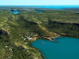
Kuri Bay
A remore coastal location, Kuri Bay is the closest settlement to Bigge Island. Located 223 km north-east of Derby, Kuri Bay is the home of Australia's first cultured pearl farm and is named after the company's first principal, Tokuichi Kuribayashi (1896-1982). The Japanese-American-Australian company commenced operations in 1956 following the Western Australian Government repealing the Pearling Act that prohibited the production, sale and possession of cultured pearls. By 1973 the Kuri Bay operation was producing 60% of the worlds large white South Sea pearls. Paspaley, the biggest supplier of South Sea pearls in the world, has one of their largest and most well-known pearl farms located at Kuri Bay. The bay is part of the Prince Regent Nature Reserve and the Kunmunya Aboriginal Reserve.
Book Vehicle Hire

Book Accommodation

Design by W3Layouts | Content © 2013 Phoenix Group Co. | Sales: phone 1300 753 517, email: [email protected]