
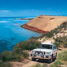
Protecting the northern tip of Peron Peninsula is Francois Peron National Park, an impressive area of acacia cloaked red dunes and arid shrubland surrounded by turquoise water. Most of the park is a four-wheel-drivers paradise, offering remote camping sites and access to beaches and fishing spots. In the south is the Peron Homestead where you can explore the park's historic past or relax in the artesian hot tub.
Francois Peron National Park plays a key role in Project Eden, a bold environmental project that is attempting to reintroduce locally extinct species to the peninsula by controlling feral predators.

The Peron Homestead
The Peron Homestead precinct provides an insight into how life was when the park was a working sheep station. A self guided walk trail around the precinct explores the history of the area, visiting the shearing shed, shearer's quarters and stock yards. Signs explain the station's interesting history along the way.
A small interpretive centre depicts stories of indigenous inhabitants, European colonisation and current day conservation programs such as Project Eden. The artesian hot tub is a popular spot to relax and soak in the hot artesian waters that originally supplied vital water to the station's stock. A barbecue and lawns are provided for picnicking.
Please remember when using the hot tub
Please keep glass out of the hot tub area
Supervise small children when soaking in the tub
The artesian water is hot and soaking for extended periods can cause dehydration. Take regular breaks and drink plenty of water
A small campground with gas BBQs and toilets is located at the lagoon and there is a site for launching boats nearby. Camping fees apply.
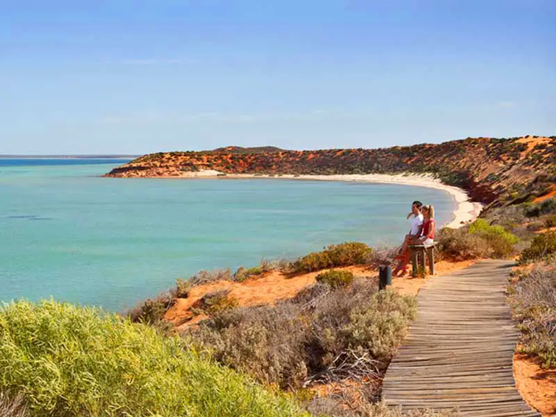
Skipjack Point and Cape Peron
At the northerly tip of the national park is Cape Peron, sitting at the confluence of two major currents, the cape attracts an impressive array of marine life. At nearby Skipjack Point you can view the wildlife from two spectacularly located viewing platforms, perched on the cliff edge with views out across the marine park.
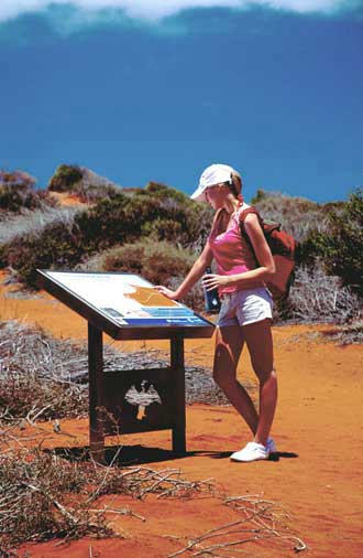
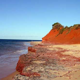
Linking Cape Peron with Skipjack Point is the Wanamalu Trail stretching for 1.5 kilometres along the cliff edge overlooking the surrounding waters. Spectacular red sand cliffs extend in either direction offering fantastic photo opportunities. The 45-minute (one-way) walk provides excellent views of the coastline and signs along the trail provide an introduction to the features of the area.
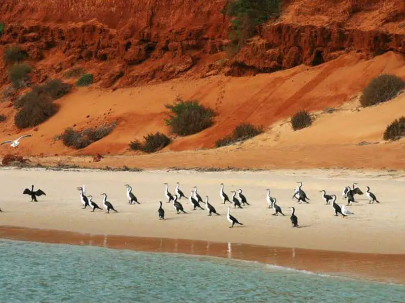
It is not unusual from the track to see marine life, such as rays, sharks, dolphins and schools of fish, as well as large flocks of cormorants along the coastline.
At Cape Peron there is interpretive signage, a picnic area with tables, toilets and beach access. Try your hand at fishing here to see what might be lurking offshore. Further out to sea is the shipwreck of the Gudrun, wrecked in 1901 and now a popular dive spot for experienced divers.
Herald Bight
The only camp site on the eastern side of the national park, Herald Bight offers some protection from the prevailing south-westerly winds. Once a pearling camp in the late 1880s, you can still find pearl shell on the beach, signs of times long past.
The informal campsite has a toilet and small boats can be launched from the beach for access to the Shark Bay Marine Park.
Big Lagoon
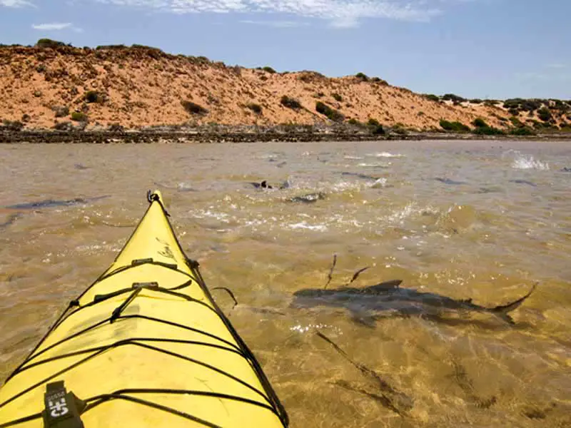
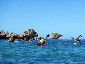
An important fish nursery, Big Lagoon's northern waters are a sanctuary zone within the Shark Bay Marine Park, where fishing is prohibited. Exploring this attractive turquoise lagoon by canoe or sea-kayak is a great way to get up close and personal to this natural gem.
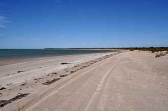
Bottle Bay, Gregories and South Gregories
These popular sites are all located within a few kilometres of each other on the northern beaches of the park. All three campsites are old favourites for fishers and beach lovers due to their proximity to the beach and easy access for launching dinghies and trying a spot of fishing. Facilities are basic with only toilets and gas BBQs provided; therefore campers will need to be self reliant. There is no drinking water so ensure you bring enough for your stay.
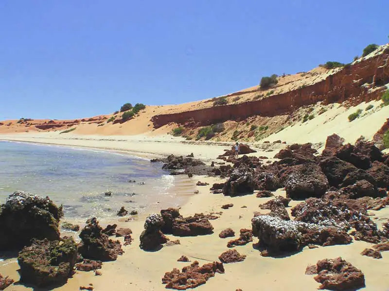
Take a walk along the beach and marvel at the rich red cliffs contrasting with the surrounding turquoise water. At Gregories, a rock shelf parallel to the coast is an excellent spot for snorkelling with the chance to drift along the wall and spot some of the local marine life.
Fishing is popular along this stretch of coastline either from the shoreline or small dinghies launched off the beach. Whiting, bream and kingfish can all be caught in the area.
Cattle Well, just south of these campsites is a day use area that offers the chance to wet a line and possibly catch a feed of whiting. No camping is permitted here.
Things to remember
Soft tracks make driving in this area hazardous. Reduce your tyre pressure to 20psi (or less if required) or risk getting bogged. When camping in these areas use the existing camp sites. Campers encroaching on the neighbouring shrubland have caused significant environmental damage. Wood-burning fires of any kind are not permitted. Please use the gas barbecues at the camp sites or bring a gas BBQ with you.
Access
Access to the park is from the Monkey Mia Road, about four kilometres east of Denham. The road to the Peron Homestead is usually accessible for 2WD vehicles but conditions vary so check with the Department of Environment and Conservation in Denham for more detail. For travel further north into the park, a high-clearance 4WD is essential. It is imperative that you lower your vehicle's tyre pressure before travelling beyond the Peron Homestead. This area is also not suitable for large caravans or boat trailers; only camper trailers and dinghies may be taken beyond this point.
Many old station tracks are being revegetated, and some are for management purposes only. Follow the signs and stay on the correct roads. Do not drive over the soft gypsum pans (birridas). Their geological structure consists of a thin surface crust over a bog mire, kept wet by groundwater. Vehicles attempting to cross birridas will get bogged. The recovery of bogged vehicles is not only costly and time consuming, but scars the birrida and degrades the surrounding vegetation. These landscapes are fragile and very difficult to rehabilitate.
Camping
Camping areas are located at Big Lagoon, Gregories, South Gregories, Bottle Bay and Herald Bight. Each campsite is on the coastline with easy access to the beach for fishing and for launching small dinghies. There is no booking system so sites are available on a first come-first served basis. The busiest times are during the school holidays and when the southerly winds drop in winter.
Only limited facilities are provided. No provision is made for caravans. Carry all of your rubbish with you when leaving the park. To protect native plants and animals, open fires, firearms and pets are not allowed.
Four-wheel-driving and commercial tours
Most of the park is only accessible by 4WD. All tracks north of the Peron Homestead are deep soft sand offering challenging conditions for drivers. Low clearance vehicles, caravans and large trailers are not suitable on these deeply rutted tracks.
You can use your own 4WD vehicle for a trip to the northern parts of the park or take a 4WD tour with a company from Monkey Mia or Denham. Tours visit the lookouts at Skipjack Point and other scenic locations in the park. Visit the Shark Bay tourism website for more information.
Tyre pressure is of paramount importance. Many a driver has become stuck on the tracks because they have failed to drop their tyre pressure, sometimes with almost catastrophic consequences. Generally tyre pressure should be reduced to 20psi or less depending on your vehicle. Tyres can be reinflated back in Denham or with your own compressor.
Walking
Two formal walking tracks are provided within the park:
Wanamalu Trail
Location: between Cape Peron and Skipjack Point
Distance: 1.5km
Time: Allow 45min each way
Features: Spectacular views of marine life from top of sand dunes and two viewing platforms. Brilliant red sand dune cliffs ideal for photography. Wildflowers in spring. Signs explain many of the fascinating features of the walk.
Station Life Walk Trail
Location: Peron Homestead
Distance: 300m
Time: Allow 45min
Features: this walk around the historic homestead precinct explores the shearing quarters, stock yards and other features from the time when the park was an operating sheep station. Signs explain many of the fascinating features of the walk.
Boating, fishing, swimming and kayaking
Fishing is a popular activity in the Shark Bay area, and many species will take a bait all year round. Species commonly encountered on Peron Peninsula include whiting, bream and kingfish. Dinghies can be launched from the beaches at Big Lagoon, Gregories, South Gregories, Bottle Bay and Herald Bight. Larger boats can be launched at the formed boat ramps at Denham and Monkey Mia.
Please remember that special rules apply to fishing and other activities in the Shark Bay Marine Park. Fishing is not permitted in sanctuary zones such as in the northern waters of Big Lagoon, an important fish nursery habitat. In the special purpose zones around Cape Peron and the mouth of Big Lagoon, drop nets for crabs are allowed but set netting and spearfishing are not permitted. Because of the prevalence of dolphins and dugongs, waterskiing and freestyle jet skiing are also not permitted.
Swimming is fine at all camp site beaches however it is not recommended at Cape Peron due to the meeting of two strong currents.
The ledge close to shore at Gregories is an excellent snorkelling site where you can drift along and observe the abundant marine life. The ledge can be accessed from shore but wear protective shoes because of the presence of stonefish in the area.
Lying in about 6 metres of water about 10km off Cape Peron is the wreck of the Gudrun, the largest wooden shipwreck off Western Australia and home to a stunning proliferation of marine life. Scuba divers may spot groper, lionfish, pilotfish, batfish, sweetlip, trevally and mackerel. Be aware, the currents can be very dangerous and the site should only be dived on a turning tide (preferably a neap tide). Novice and visiting divers should dive with an experienced operator. The wreck is now protected by the Gudrun Sanctuary Zone; all fishing, collecting and removal of artefacts is prohibited.
Sea-kayaking is another popular activity around Peron Peninsula, the shallow and protected waters provide the ideal setting for exploring the coastline around the park. Trips between Monkey Mia and Denham around the perimeter of the park are offered by commercial companies based in Perth. Visit Tourism Western Australia's website for all tour bookings. Guidelines are available from the Department of Environment and Conservation office in Denham.
Wildlife
Francois Peron National Park and the Shark Bay World Heritage Area are home to some of the rarest and most endangered animals in Australia and the world. The region's bird-life is particularly rich, with land-based wading and migratory birds all being seen on the Peron Peninsula. Emus, fairy-wrens, scrubwrens, finches and wedgebills are the most common species but visitors may also spot the thick-billed grasswren, a threatened species once widespread on the mainland but now restricted to a small area that includes the national park
Nearly 100 reptile and amphibian species live in Shark Bay. Creatures as beautiful and diverse as the thorny devil, racehorse goanna, bobtail skink, knob-tailed gecko and bearded dragon are abundant. Snakes such as the gwardar, mulga and woma python, a threatened species, are often seen basking in the sun.
From the cliffs at Cape Peron and Skipjack Point, visitors may spot bottlenose dolphins, dugongs, green and loggerhead turtles, sting and manta rays and sharks. Visitors can also find tracks of euros (small kangaroos), echidnas and native mice scattered over the red sand.
Plants
Shark Bay is an important transition point between the temperate vegetation zone of Western Australia's south-western region, and the desert vegetation zone of the north and east. As a result, two distinct vegetation types are found in the park. The red sandy plains are dominated by desert-adapted acacias (wattles), while flowering plants from cooler climates, such as hakeas and grevilleas, reach their most northern range on the peninsula. Living at the extreme, these 'pioneer' species have stretched their survival capabilities to withstand the harsh environment.
Peron Peninsula also boasts a dazzling array of wildflowers. One of the most striking and abundant flowers is the Shark Bay daisy, a creeper that displays its large mauve to pink flowers well above surrounding shrubs. Navigator William Dampier, who collected plants from the region in 1699, was impressed by the blue flowering plants, including wild tomato bush, halgania, and his namesake, the hoary Dampiera. Dampier's specimens of the pink coastal thryptomene, a type of heath, are some of the earliest records of Australian plants. Along with white myrtle, yellow wattles and purple peas, they form a colourful display in spring.
Geology - gypsum birridas
Interspersed throughout the park and across Peron Peninsula are gypsum claypans known as birridas. Thousands of years ago, when sea levels were much higher than at present, most birridas were landlocked saline lakes. In more recent times the sea has invaded some birridas, such as Big Lagoon, to form shallow inland bays. Take a scenic flight over the peninsula to gain a full appreciation of these spectacular geological features.
Aboriginal and European Heritage
Aboriginal people have lived on Peron Peninsula, or Wulyibidi in the Malgana language, for about 25,000 years. At that time, much of Shark Bay was an arid valley with little fresh water. The first written descriptions and images of Malgana lives were documented by French explorers early in the 19th century. One of the explorers was French naturalist Francois Peron who made meticulous descriptions of anthropology, oceanography, meteorology and zoology during Nicholas Baudin's 1801 and 1803 expeditions. The park bears his name in recognition of his contribution to Australia's natural and social history. Read more about Shark Bay's cultural heritage.
The peninsula was managed as a sheep station until 1990, when it was bought by the State Government. In 1993 Francois Peron National Park was declared. Today, Peron Homestead offers visitors an insight into what life was like during the pastoral era. Take the self-guided walk to get a feel for the days of pastoralism.
Text: Shire of Shark Bay
Book Vehicle Hire

Book Accommodation

Design by W3Layouts | Content © 2013 Phoenix Group Co. | Sales: phone 1300 753 517, email: [email protected]