
The coastal town of Kalbarri has developed in recent years from an isolated community of fishermen and holiday shacks to a holiday destination offering a wide choice of activities and accommodation.
Kalbarri is so popular these days, during peak holiday season the population of Kalbarri increases substantially to the degree that it is advisable to book accommodation in advance at these times. The two drawcards that have made this so are the Murchison River gorges off the road leading to the town and the stark, dramatic coastline to the south. It is around them that most of the activities on offer to visitors revolve.
Around town
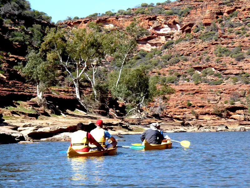
Sandboarding, canoeing and quad biking are popular activities. There are several companies offering cruises up the magnificent Murchison River, departing from the Jetty in Kalbarri; canoes or kayaks can be hired for those who prefer a more 'hands-on' trip up the river, either for travel as part of 12 km guided safari, or on their own.

Aerial Tours
Several aerial tours are available that take in the Zuytdorp Cliffs, Murchison River Gorges (Kalbarri National Park, Abrolhos Islands, Monkey Mia, Coral Bay, Ningaloo Reef and more. For the Monkey Mia tour, the plane can land at Shark Bay airport and the tour can continue at the beach with the dolphins before flying back to Kalbarri. Visitors who don't have the time to visit the Shark Bay region find this flight the perfect way to incorporate them into a visit to Kalbarri.

Kalbarri Coast
The coastal gorges and cliffs provide many excellent photo opportunities, as well as coastal walks, swimming and surfing on the beaches up and down the coast. Recreational fishing is also popular, with good catches being taken from the beaches at Wittecarra Creek and Blue Holes as well as from the cliffs.
The highlights of the coastal Gorges are:
Red Bluff - From the lookout you can view the notorious Zuytdorp Cliffs to the north.
Mushroom Rock - a rock shaped as a mushroom
Rainbow Valley - Layers of different coloured minerals form a spectrum in stone
Pot Alley - The view from the top shows the beauty of the coast while rock steps lead down to a secluded beach
Eagle Gorge - panoramic view from the top or wander down to the beach
Shellhouse and Grandstand - See the effects of the Indian Ocean continually crashing against the soft limestone cliffs. Island Rock - Part of the limestone cliff which has been isolated from the shoreline like the twelve apostles in Victoria.
Natural Bridge - The waves have slowly carved a hole in the limestone to form a natural bridge.
Castle Cove - Another lookout point to view the cliff formations.
Wildlife
Aquatic wildlife is plenteous in and around Kalbarri. Dolphins are regularly seen off the coast as are whales during the migratory season of June to October. Rain, hail or shine, the Pelicans are fed in Kalbarri each morning of the year at 8:45. There is also a Seahorse Sanctuary, Kalbarri Oceanarium and Rainbow Jungle Australian Parrot Breeding Centre.
The Rainbow Jungle (The Australian Parrot Breeding Centre), located a few kilometres south of the town centre, features hundreds of exotic species of birds in their native habitat plus a walk-in cage allowing humans to interact with the birds. Red Bluff and other coastal cliffs and formations are located south of the town.

Kalbarri National Park
Inland activities tend to be focused around the Murchison River, which winds its way through a series of very scenic sandstone gorges on its way to its estuary at the township. The gorges that lie within Kalbarri National Park can be accessed by a series of well maintained unsealed roads that lead from the main road into Kalbarri to a number of lookouts. Walking tracks lead from these lookouts into the gorges themselves. There are plenty of optional walking and hiking trails through the gorges which are clearly marked. Wildflowers bloom in abundance between August and October after winter rains.

Gorge Bushwalks
The most popular walking track in Kalbarri National Park can be found at the Nature's Window, called The Loop. It is an 8km trek which takes you along the top of the gorges, then slowly winds down to a sandy beach at the river front (great spot for a packed lunch). The Loop then follows the river around the gorges and cliff faces and eventually arrives at another sandy beach from where, you can see the marked path leading back up to Natures Window. To walk the whole track requires a fair amount of fitness and agility as there are several difficult spots, mainly along the cliff face. Allow 3-4 hrs. which is adequately takes in rest stops and photo taking.

There are also longer walks throughout the National Park. A 38km trek from the Ross Graham Lookout to The Loop requires up to 4 days to cover. Two day hikes can also be done from either the Ross Graham Lookout to the Z-Bend or the Z-Bend to The Loop (where Nature's Window is). Maps and further information are available from the Kalbarri National Park information centre which is situated on the Ajana-Kalbarri road just before you enter the town of Kalbarri itself.
Where is it?
Kalbarri is a coastal town in the Mid West region located 592 km north of Perth, 167 km north of Geraldton, at the mouth of the Murchison River. It is connected by public transport to Perth via Transwa coach services N1 and N2.

Port Gregory and Hutt River
The road between Kalbarri and Port Gregory, while not being a major highway, is quite adequate. The early section through the National Park may be a little rough in places but once out of the park it is a dirt road which is nearly as good as a sealed road. Gregory is a fascinating settlement where convict history, fishing, wheat lands and 'getting away from it all' holidaying are an enthralling mix. There can be few places in Australia where wheat fields grow right next to huge white sand dunes, where an historic convict settlement stands on the shores of a pink lake, and where a reef runs parallel to the coast forming a natural breakwater for a small harbour.
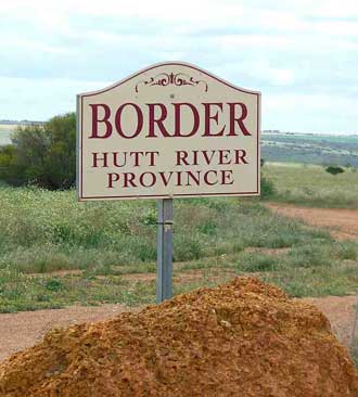
If you continue on (do not take the turn to Port Gregory) you come to the infamous Hutt River Province, the unassuming home of Prince Leonard and Princess Shirley of Hutt. This amusing episode in Australian eccentricity resulted when Prince Leonard renamed his wheat farm the Hutt River Province, declared himself a prince and his wife a princess, seceded from Australia and Western Australia and, as a nice little earner, started printing his own stamps. Of course none of his grandiose ambitions had any validity but he did attract an inordinate amount of publicity. There is some doubt about the Prince and Princess's enthusiasm for visitors. There is no welcoming sign at the gate - which boasts a rather faded replica of the province's coat of arms.
Interestingly Prince Leonard is not alone in his regal aspirations. In Strahan in Tasmania there was a self-proclaimed Lord who ran his own Ba-k (he was legally not allowed to call it a bank). He was closed down and the ba-k is now a gift shop.
Brief history
The local Aboriginal people inhabited the area for thousands of years and have a dreaming story about the Rainbow serpent forming the Murchison River as she came from inland to the coast. Kalbarri was named after an Aboriginal man from the Murchison tribe and is also the name of an edible seed.

The first European people to visit the area were the crew of the trading ship belonging to the Dutch East India Company, the Batavia, who, in 1629, put two mutinous crew members ashore near Bluff Point just south of the town. They were the first Europeans to attempt settlement on the Australian mainland. What happened to them is not known. Their arrival is commemorated at the mouth of the Wittecarra Creek near Red Bluff where a cairn has been erected with the inscription: 'It is believed the first permanent landing of white men in Australia was recorded here, at the mouth of the Wittecarra Creek.'
 Wittecarra Creek
Then in 1712 a Dutch ship named the Zuytdorp was wrecked on a reef north of Kalbarri. It is claimed that the ship sunk with a bullion of 100 000 guilders and pieces of eight aboard. This was not an isolated event. By the eighteenth century it had become commonplace for Dutch ships to round the Cape of Good Hope, sail west along the Roaring Forties, and then sail north along the West Australian coast towards the Dutch East Indies.
In 1839 Lieutenant George Grey, while attempting to explore North West Cape, was shipwrecked near the mouth of the Murchison. He was forced to walk back to Perth and thus became the first white explorer to travel along the coastal strip of the Central West. The area was settled intermittently through the late nineteenth and early twentieth century by miners and fishermen. In 1848 the Geraldine lead mine was opened up. Visitors with 4WD vehicles can visit the ruins at the eastern edge of the Kalbarri National Park.
Still, as recently as 1943, there were only a few crayfishermen living in the area and the township, if it could be called that, was known simply as 'The Mouth of the Murchison'. No one knows where the word 'kalbarri' comes from. Some sources claim it means 'seed' or 'woody pear' in the dialect of the local Aborigines while others claim it was the name of an important member of the local community.
Book Vehicle Hire

Book Accommodation

Design by W3Layouts | Content © 2013 Phoenix Group Co. | Sales: phone 1300 753 517, email: [email protected]