
Located 468 km west of Katherine along the Northern Territory/Western Australia border, Keep River National Park is noted for its striking landforms.
Short-eared rock wallabies, white-quilled rock pigeons and sandstone shrike thrush are some of the interesting animals that inhabit this area.
The most comfortable months to visit the Park are from May through to the end of August, when temperatures range from 35 degrees Celsius max down to 10 degrees Celsius min.
How to Get There
The Park entrance is 3 km east of the NT/WA border. Formed gravel roads suitable for 2WD vehicles lead to the main attractions. During the wet season roads may be closed due to flooding. All vehicles are restricted to formed roads.
Camping
Two camping areas have been provided: Gurrandalng, located 18km from the Park entrance and Jarnem, located 31km from the Park entrance. Camping facilities include tables, barbecues and pit toilets. Drinking water is available at two sites within the Park. Generators are permitted in the park at the Gurrandalng campground only, but must be turned off by 8:30pm.
Generators are permitted in the park at the Gurrandalng campground only but must be turned off by 8:30pm.
Walking Tracks
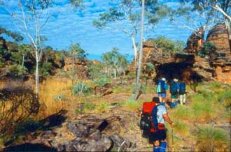
There are some excellent bushwalking tracks that explore the rugged terrain of sandstone formations that are similar in structure to the Bungle Bungles, including the Keep River Gorge and some Aboriginal art sites.
Bushwalkers planning long walks or camping overnight outside the formal camping areas MUST NOTIFY a Ranger before setting off. Special conditions for overnight hikers involves getting a permit which can take up to a week or more to process so you need to be pre-organised and contact the Rangers for a copy of the permit and the other information you need to provide Rangers with.
NO self guiding pamphlets are available for any of the walking tracks here. There is interpretive information at the walks and visitor centre.
You will need drinking water, appropriate footwear and a hat. It is also advisable to have the topographical 1:100,000 scale map of the area.
The Park falls within the Aboriginal tribal area of the Mirriuwoong and Gadjerong Aboriginal People. The Jinumum walk and the Lang-gerrbi (Nigli Gap) walk provide the visitor with the chance to see some of the rock art characteristic of the area.
Book Vehicle Hire

Book Accommodation

Design by W3Layouts | Content © 2013 Phoenix Group Co. | Sales: phone 1300 753 517, email: [email protected]