
King Sound is a large gulf in northern Western Australia. It expands from the mouth of the Fitzroy River, one of Australia's largest watercourses, and opens to the Indian Ocean. Other rivers that discharge into the sound include the Lennard River, Meda River, Robinson River and May River. The sound is about 120 km long, and averages about 50 km in width.
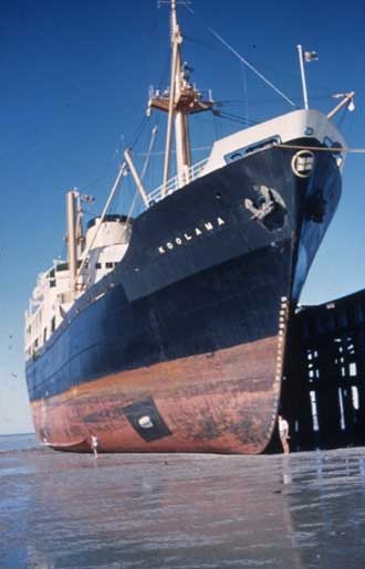
The port town of Derby lies near the mouth of the Fitzroy River on the eastern shore of King Sound. King Sound is bordered by the island clusters of the Buccaneer Archipelago to the East and Cape Leveque to the West. In the 1880s it was one the sites in the Kimberleys of a short lived gold rush.
The northern shores of King Sound are very different from the sandy pindan plains on the opposite side of the Dampier Land peninsula. Yampi Peninsula, which thrusts a great rocky fist out between King Sound and Collier Bay, is a meeting ground of the harsh sandstone country of the plateau and the basalts which are so important throughout the Kimberleys.
Its straight southern edge is formed by the fault lines bordering the sedimentary rocks of the plains to the south. Low, bare quartzite ridges are separated by gentler basalt-filled valleys, with white grass and sorghums which might be marginally useful grazing country in the higher rainfall coastal belt, were they not so inaccessible.
High Tides
King Sound has Australia's highest tides and one of the highest in the world. They are surpassed only by the Bay of Fundy, Nova Scotia, Canada, which has 15 metre high tides, and Bristol (UK) 14.6m, Mont Saint Michel (France) 12.3m, Puerto Gallegos (Argentina) 13.2m and Bhaunagan (India) 12.2m.. High tides in Western Australia are King Sound/Derby 11.8m, Yampi Sound 10.9m, Broome 9.8m and Wyndham 8.4m.
King Sound is a tide ravaged sound, as reflected in the names of its geographical features, like Whirlpool Pass, Hells Gates, Escape Pass, Alarm Shoal, Tide Rip Islands and The Graveyard. It is in complete contrast to the adjacent, peaceful, Yampi Sound which has high tides, but whose shores are not subject to the scouring effect of the rising and falling tide as it moves in and out of the channel-like Sound. For this reason, King Sound is often bypassed by cruising yachties. However, the deeply indented bays and rivers on the eastern side of King Sound offer protection from both wind and tide, with some great scenery as a bonus.

Cape Leveque
Cape Leveque is a beautiful hidden pocket within the Western Australian Kimberley region, located on the tip of the Dampier Peninsula north of the towns of Broome and Derby. The rugged beauty of the coast around Cape Leveque is quite unlike anything seen elsewhere in Australia, bordering on desolate yet with an undeniable rugged charm. It is one of the only places in Australia where the desert meets the sea.
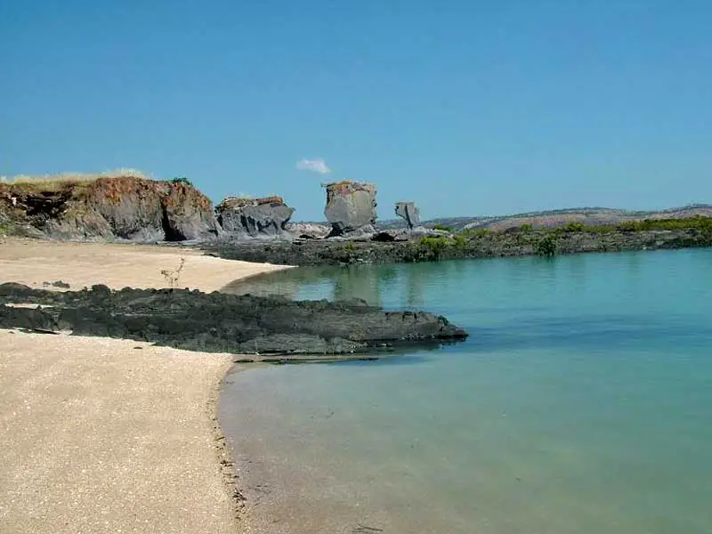
 Cone Bay
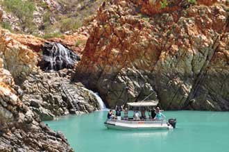
Cascade, Cone and Strickland Bays
Cascade, Cone and Crawford Bays lie crumpled and creased, their shores notched with a myriad of mangrove estuaries, bays and sand beaches; plunging cliffs and rocky masses; stony islands and innumerable hidden reefs that litter these offshore waters. Numerous freshwater springs flow from the hills of King Leopold Sandstone into the bays creating pockets of rain forests.
These three bays are generally the first areas visited by cruises of the Kimberley coastline operating out of Derby. Located on the east side of the head of King Sound, they showcase the Islands of the Buccaneer Archipelago, the picturesque coastal rocks, fast flowing faterfalls, fine sandy beaches, sparkling water of the region and magnificent sunrises and sunsets for which the Kimberley is renowned. Days are spent cruising through Cascade Bay and Hell’s Gate (usually a visitor's first look at the rush of water created by the tide movement), entering Whirlpool Passage - a channel that funnels the extreme tides into whirlpools, reef fishing at Hidden Island and taking a refreshing swim at Silica Beach, with its brilliant white squeaky silica sand, picturesque rocks and crystal clear water. In the evenings, there is nothing better than to watch the sunset while enjoying evening nibbles and refreshments on deck or from a beach camp.
 Edeline Island
Edeline Island is famed for its siltstone rock formations that resemble sculptures. The islands are known locally as "The Graveyards", as they contain 19th century graves of pearl divers; three unmarked, one with an inscription (dated 1891). Cone Bay, with tides of up to 11 metres twice a day, is fantastic for growing fish; its 'water circles' are in fact polar sea-cages used to breed Saltwater Barramundi.
 Crocodile Creek
Yampi Sound
Yampi Sound is a part of the Indian Ocean off the coast of northwestern Australia, located between King Sound and Collier Bay. The islands of the Buccaneer Archipelago, located in the sound, contain rich silver and iron ore deposits. The high grade iron ore deposits has been mined in the Sound since the 1950s. A copper mine also operated at Coppermine Creek on the mainland side of the sound.
Many creeks discharge directly into the sound including Coppermine Creek, Crocodile Creek, Silvergull Creek and Dogleg Creek. The Sound contains many islands of the Buccaneer Archipelago the largest being Koolan Island; others include: Cockatoo Island, Irvine Island, Bathurst Island, Finch Islands, Hidden Island, Baylis Islands and Iron Islands.

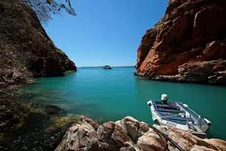
Buccaneer Archipelago
The Buccaneer Archipelago is a stunningly rugged area off the Kimberley coast in Western Australia, consisting of up to 1000 islands. The scenery is perhaps the most spectacular of any island group in Australia, with secluded white sandy beaches, patches of rain forest, mangrove estuaries, plunging cliffs, indigenous rock art and hidden reefs that litter offshore waters.
Indigenoug history
The traditional owners and original inhabitants of the area are the Indigenous Australians the Nimanburu, Njulnjul, Warwa peoples. Cape Leveque was a camping ground. Their huge middens over shadow the small caravan park resting on the shores of the Indian Ocean. The Nimanburu occupied the coast of King Sound from Repulse Point south to include swamp plain at mouth of Fraser River. They did not use rafts and knew nothing of seagoing. Their speech is described as 'heavy Warwa,' and they are considered to be related to the Warwa people.
The Njulnjul occupied the Dampier Peninsula on western side, from Cape Borda south to Sandy Point, extending across peninsula to Carlyle Head and Goodenough Bay. Formerly they held more territory on the King Sound side; this was usurped by the Nimanburu.
The Warwa lived on the eastern shores of King Sound from Fraser River to Round Hill, Stokes Bay; inland to upper Logue River; on Fitzroy River only to Yeeda; at Derby; north of Meda extending inland about 65 km. Eastern and western sections of the tribe were almost cut off from each other by movement of Njikena down Fitzroy River before European settlement and contact was maintained only along coastal swamps flooded at high tides.
European history
King Sound and the region surrounding it and the town of Derby, which stands on its shores, was first explored in 1688 by William Dampier. This statement, now widely accepted, is, in part, one of those strange cases of the rewriting of history. Dampier was one of the crew of the Cygnet which sailed around the King Sound area for three months in 1688. The Cygnet was actually under the command of Captain Read but it was Dampier who, upon his return to England, published A New Voyage Round the World and thus was incorrectly credited as leading the expedition which anchored in Cygnet Bay and sailed around King Sound.
 Dampier Monument, Derby
Near the Derby jetty is a bicentennial monument to William Dampier who arrived near the present site of Derby in 1688. He reached the head of King Sound on 5th January 1688. After Dampier came Phillip Parker King who, from 1818 to 1822, explored the coasts of Western Australia and the Northern Territory including King Sound (which is named after him) upon which the port of Derby is located. King's explorations generated no interest in the region. In 1837 George Gray and John Stokes explored the eastern coast of the sound naming the Fitzroy River after Captain Robert Fitzroy R. N. and also naming Stokes Bay.
William Dampier's description from the Cygnet off Cape Lévêque on 5 January 1688: "This part is all a low, even land with sandy banks against the sea … the points rocky and so are some o the islands in the bay… The soil is dry and sandy, destitute of water, except you make wells, yet producing divers sorts of trees."
It wasn't until 1879 that any European settlement of the area occurred. Isolation and harsh conditions had combined to ensure that only the most tenacious of pastoralists and workers came to the area. Long before European settlement, however, King Sound, Buccaneer Archipelago and the surrounding peninsulas were part of a coastal trading route of the many Aboriginal tongues and the artefacts from the Kimberley region, such as the ochre earth and large trochus shells were valuable trading items. There are places sacred to the Aboriginal owners throughout the region. The Bardi people of the Kimberley for instance, were one of the few Aboriginal peoples that were seagoing.
Book Vehicle Hire

Book Accommodation

Design by W3Layouts | Content © 2013 Phoenix Group Co. | Sales: phone 1300 753 517, email: [email protected]