
An old goldmining town of the Murchison Goldfields that now serves a scattered pastoral district. Increased gold prices has seen a number of huge open cut mines established in the area.
The area once had three separate townsites - Mount Magnet, Boogardie, and Lennonville. Boogardie has since been swallowed up into the open cut mining operations at Hill 50.
Unusual for such a large mining community, Mount Magnet has never had a public battery. The nearest battery was built 5 km west, in Boogardie. However its gold-rush heyday can be seen in its very wide main street with three hotels, a race course and a golf course complete with oiled greens.
Surrounding the town are remnants of old mining operations, and to the north east are significant Aboriginal sites being preserved jointly by the local community and the West Australian Museum.
Today, it is both mining and pastoral industries which form the economic base of the Shire of Mount Magnet, however the beautiful wildflower blooms that can be seen between July and September each year also draw many tourists to the town.
Heritage Walk
The Heritage Walk is a leisurely stroll through town offering visitors a small part of the history of Mount Magnet. The walk down the main street still gives a feeling of days gone by, with its wide road and old shop fronts. Just around the corner see the Old School Masters House and Old School, now renovated and housing the Rural Transaction Centre. The first Police Station has been destroyed by fire but the Station Masters House, Original Bank of Western Australia and Old Post Office and Residence, plus other sights are included on the Heritage Walk.
Amphitheatre
On the Boogardie-Lennonville road there is a very interesting rock formation known locally as the Amphitheatre. For over eighty years it has been used as a local picnic spot. It is one of those magic places which sensitive people say brings them close to nature. It appears to be an ancient waterfall from an older land level, a laterite capped island in space. It was always a great lovers’ trysting place and it has been whispered that a large percentage of Mount Magnet's population originated from there.
The Granites
7 km north of the town, The Granites are an escarpment about 15 metres high, formed by the erosion of the soft white granite from beneath a hard red brown iron cemented capping. The caves formed in the soft granite have fantastically sculptured surfaces formed by the small curved quartz veins in the granite. The Granites are a popular picnic spot and are situated approximately 9km north of Mount Magnet, along the Great Northen Highway.
For at least 20,000 years prior to settlement the Aborigines considered the Mount Magnet region their home. The Granites is a place of strong cultural significance to the Badimia tribe. Their old carvings and paintings can be seen at several sites at The Granites. Paintings on the rocks at Walganna Rocks have been dated at 9,000 years old, making them of a similar age to cave paintings in Europe. There is also a “Gnamma” hole in this area known to a few local people, this being a traditional native well covered by a stone. Ceremonial and burial sites are also located within The Granites area. Visitors and residents are asked to respect the cultural significance of the land and sites. A beautiful place to explore and picnic, especially at sunset.
Lennonville
The remains of the mining town of Lennonville lie just north of the Mount Magnet townsite. At the peak of the gold rush in the region, in the early 1900’s it is believed that the population of Lennonville reached 3000, making it the most important of the three townsites of Mount Magnet, Boogardie and Lennonville. During this peak time there were five hotels in the townsite. In 1909 after several years of slow decline, a huge fire swept through the main street of the town, provoking a general exodus. Lennonville was abandoned at the start of World War I.
Today you can visit the vacant townsite, explore through what was a thriving township less than 100 years ago. The old railway platform remains in Lennonville and has a great collection of relics from the old town left by fossickers. A plaque in the Lennonville Cemetery names those interred in this cemetery and the “old” Lennonville Cemetery a few km away. The plaque gave the details of a couple who had 5 of their children die aged between 12 years and just days old, all in one 7 year period.
Where is it?
569 km north east of Perth and 126 km east of Yalgoo on the Great Northern Highway.
Mount Magnet Tourist Trail
The Mount Magnet Tourist Trail is a 37 kilometre self-drive trail that takes in sights such as the Amphitheatre, Granites, caves and old mining settlements. There are incredible displays of wildflowers (during the season), beautiful picnic places and spectacular rock formations. Visit the Cemetery and imagine the hardship and suffering the pioneers of this beautiful country must have endured. Finish up your day with a visit to the Museum with an assortment of pastoral and mining memorabilia, or have a picnic and explore the beautiful Granites at sunset.
Gascoyne Murchison Miners Pathway
The Gascoyne Murchison Miners Pathway is a self-drive tour throughout the historical mining regions of the MidWest and Gascoyne. The pathway is approximately 970km in distance and travellers should allow a minimum of three days. The journey not only involves seeing historical sites within the old mining towns and disused mines but is also a great way to see the spectacular wildflower displays unique to this region.
Mount Magnet is situated at the crossroads of the Miners Pathway making it the perfect place for an overnight stay. Highlights of the Pathway include- Jokers Tunnel, Big Bell Hotel, London Bridge and old gold mines. Miners Pathway is suitable for all vehicles, but it should be noted that the road from Meekatharra to Sandstone is not sealed- check for road condition reports.
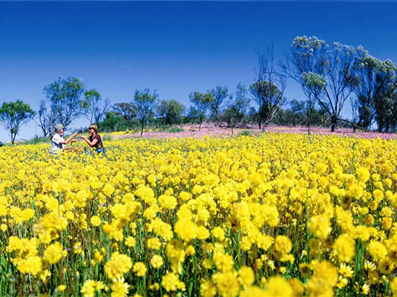
Wildflowers
During spring (September to November) the area attracts tourist viewing the natural display of everlastings that can stretch for kilometres in all directions. Being 6 hours drive from Perth makes it a comfortable day's journey for vehicles heading further north to places like Mount Augustus and Port Hedland.
Brief history
The name is derived from that of a geographical feature, which was named by explorer Robert Austin in August 1854 because of the magnetic attraction of rocks there. The Aboriginal name of the hill is Warramboo.
Gold was discovered in the Mt. Magnet area in July 1891 by the prospectors George Woodley and Tom Sampey. A townsite was surveyed and later gazetted in 1895. The railway to Mount Magnet was completed in August 1897, but it was not opened until July 1898. The line closed in May 1978.
Book Vehicle Hire

Book Accommodation

Design by W3Layouts | Content © 2013 Phoenix Group Co. | Sales: phone 1300 753 517, email: [email protected]