Australia For Everyone: Canberra


Angahook-Lorne State Park
Angahook-Lorne State Park covers 22 000 ha of coastline (from Aireys Inlet to Kennett River) and mountainous hinterland. It incorporates the Otway Ranges and is characterised by cliffs, coves, sandy beaches and rock platforms. Between the ridges are deep valleys and gullies carved by the Erskine, Cumberland, Kalimna and St George Rivers and a plenitude of streams.Vegetation ranges from dry heathland to cool temperate rainforest. Messmate, blue gum, mountain grey gum and mountain ash predominate while the wetter areas feature an understorey of blackwood, tree ferns, satinwood, blanket-leaf and musk daisy-bush. There is a plenitude of fauna including 170 bird species, such as the rare crested penguin and peregrine falcon, along with (mostly nocturnal) marsupials such as eastern grey kangaroos, swamp wallabies, marsupial mice, echidnas, ringtail and brushtail possums and bandicoots. In summer the park tends to be somewhat cooler than average and very pleasant.
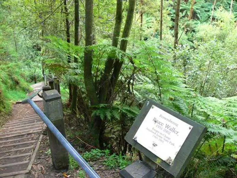
There are several bush camping locations which have no facilities and require no bookings. One is the Allenvale Mill site which is a short distance along Allenvale Road. From this site you can walk north along Saint George River to Phantom Falls (2.5 km return). About 2.5 km along Allenvale Rd there is a turnoff on the right into Sharps Track and it is just one kilometre to another campsite. There are two more campsites just off the Great Ocean Road to the south-west of Lorne (turn right 11 km south of Lorne onto Jamieson Track or turn right onto the Wye River Road 14 km south of Lorne). 10 km north of Lorne along the Deans Marsh Road the Big Hill Track heads off to the right. There is a further campsite a very short distance along this track.
There are two major picnic areas in the Lorne section of the park. 4 km along Allenvale Rd is the Sheoak Picnic Area. There are barbecue facilities, toilets, picnic tables, fireplaces and drinking water. Another, the Blanket Leaf Picnic Ground, is 7 km along Erskine Falls Rd which runs off William St. There are fireplaces, picnic tables, toilets, drinking water and information boards. Numerous walking tracks depart from these two sites, and from the Great Ocean Road and Erskine Falls carpark. Information on these walks and on the park’s many waterfalls are outlined in a separate section below.
The creeks, beaches and rock platforms offer fine fishing opportunities. Horseriding, cycling and mountain bike riding are forbidden on walking tracks and not recommended on the narrow, winding, busy Great Ocean Road but all can be pursued on minor roads.
Note that the park is very wet in winter and early spring and road conditions can be dangerous. Many roads in the park are 4WD only and are completely closed from July to October. The best time for driving is November to May. A recommended route (73 km) takes in some outstanding coastal scenery, tall mountain forest, a walk along the Grey River and Erskine Falls. From Lorne head south-west along the Great Ocean Road to Kennett River (22 km) then turn right onto the Grey River Road (19 km unsealed). This leads past the Grey River Picnic Area, where there are walking tracks, reaching a T-intersection with the Benwerrin-Mt Sabine Rd which runs along the spine of the Otway Ranges. Turn right and follow this road for 20 km then turn right onto the Erskine Falls Rd and it is 12 km back to Lorne.
Maps and pamphlets are available from Parks Victoria (tel: 131 963) and the Lorne Information Centre.
4 km along Erskine Falls Rd are Erskine Falls Cottages where accommodation, gifts and coffee are available. You can also stop to feed the parrots, tel: (03) 5289 2666.
- Angahook-Lorne State Park Visitor Guide (PDF)
Erskine Falls
Walking Tracks in Angahook-Lorne State Park
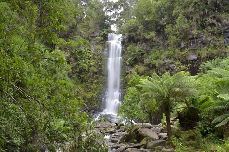
There are about many kilometres of walking tracks in the park. The Cora Lynn Cascades Walk (10 km return) starts at the Blanket Leaf Picnic Ground. It passes through fern gullies and rocky gorges past an overnight campsite to Cora Lynn Cascades (about 2 km from the picnic area). The next section (from the Cascades to the Cora Lynn carpark) is very difficult and only for experienced walkers. From the carpark the track continues on to Phantom Falls intersecting with Allenvale Road at the Allenvale Mill campsite. From here you can walk east along Allenvale Road then turn left onto the Green Break Track which eventually joins up with Erskine Falls Road which leads back to the picnic area. Another option is to follow Saint George River from the Allenvale Mill site to the coast.2 km beyond the Blanket Leaf Picnic Ground (9 km north-west of Lorne) is the Erskine Falls carpark which is the start of the Erskine Falls Walk (7.5 km one-way), which runs roughly parallel to the Erskine Falls Road, all the way back to Lorne. It is just 50 metres to Erskine Falls which tumble 30 metres into the tree fern gully below. There is a viewing platform atop the falls and a series of steps lead down to the base. Another 500 m will take you to Straw Falls and it is a further 1.3 km to Splitters Falls. This section of the walk should not be attempted when water levels are high.
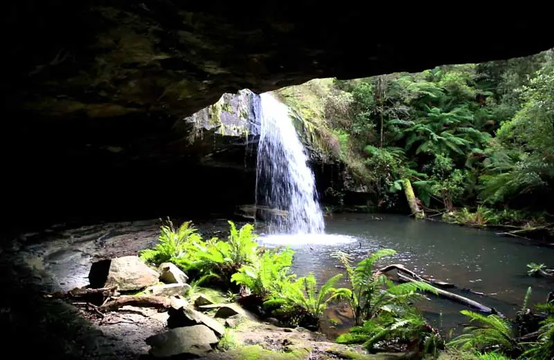
Lower Kalimna Fallss
The Sheoak Picnic Area is the starting point for the easy-going Kalimna Falls Loop Walk (8 km return) which follows the route of an old timber tramline (some of the log sleepers can still be seen) west along Sheoak Creek, first to the Lower Kalimna Falls then on to the dense tree ferns around the Upper Kalimna Falls. Return towards the Lower Falls but take the track to the right before you reach the Lower Falls. It joins up with Garveys Track which will return you to the Picnic Area.
The Sheoak Falls Walk (7 km return) heads south-east from the Sheoak Picnic Area along Sheoak Creek to Swallow Cave (where swallows nest in the rock crevices in spring) and on for another 400 m to the 15-metre Sheoak Falls (this section of the walk should not be attempted when water levels are high). Return a very short distance towards Swallow Cave then branch off to the left along the Sheoak/Castle Rock Track. After about 1.3 km there is a track junction. Turn left to Castle Rock where there is a lookout then return to the junction. Keep to the left, following the Sheoak Track north to Garveys Track which leads back to the Picnic Area.
The Phantom Falls Walk (8.6 km return) heads north-west from the Sheoak Picnic Area to Won Wondah Falls then on to Henderson Falls. From the latter, return a short distance to the track junction, keeping to the left as the track veers north, passing between the eight metre walls of The Canyon and on to Phantom Falls. From the falls follow Saint George River to the Allenvale Mill site then walk along Allenvale Road back to the Picnic Area.
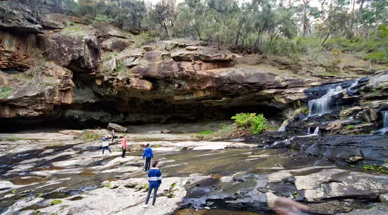
Swallow Cave
About 3 km south of Lorne along the Great Ocean Road there is a carpark with an information board on the right-hand side of the road. A walking track leads to Sheoak Falls (800 m) and it is another 400 metres to Swallow Cave.
About 6 km south of Lorne along the Great Ocean Road is a picnic area at the mouth of the Cumberland River. You can take the Cumberland Falls Walk (9 km return) by following the river for about 3 km past some excellent clifftop scenery to the Cumberland Cascades (not to be attempted when the river level is high). Return the way you came for nearly 1 km but then take the track on the left which follows a ridge north to Garveys Track. Turn right onto the latter but turn right again almost immediately onto the Sheoak Track to Castle Rock. From Castle Rock return along the track for a couple of hundred metres to the track junction and turn right. The track leads to Sheoak Falls then on to the Great Ocean Road carpark which can be followed back to the Cumberland River Reserve.