


History is littered with what-ifs and wild theories. Most are ignored, but one posed by a retired British submarine commander may rewrite the accepted history of Australia, America and half the world. Gavin Menzies, a self-confessed “outsider”, has sparked heated academic debate by claiming the Chinese beat Europeans to the New World by decades, if not centuries. If true, his theories would recast the holy trinity of European naval explorers – Captain Cook, Christopher Columbus and Ferdinand Magellan – as followers in the great wake of 15th century China’s Admiral Zheng He and his fleet of colossal, nine-masted teak junks.
Released a few years ago, Menzies’ book, 1421, the Year China Discovered The World, is seen as the book that’s has the potential to re-write history. In Australia’s case, Menzies claims Zheng’s vice-admirals, Hong Bao and Zhou Man, beat Cook to exploring the east coast of Australia by almost 350 years. Menzies believes that the two vice-admirals, both eunuchs (as was the custom for captains), arrived in Australia in 1422 – Hong on the west coast, Zhou on the east – and spent several months exploring, landing in several places.
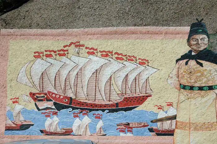
Their ships were massive – 122 metres long by 27 metres wide – not that much smaller than a modern aircraft carrier and absolute giants compared with those used by Columbus about 70 years later (see illustration). The captains navigated by the stars. Each ship had up to 1000 sailors, who were supplied with fresh vegetables, meat and rice grown on factory ships that accompanied the fleet. Sex was provided by prostitutes who came equipped with sex aids and aphrodisiacs. The Chinese were after treasure, mainly minerals. To assist exploration, Menzies says, they built small villages, complete with observation platforms for surveying, near Gympie in Queensland and Eden in New South Wales. They found lead, silver, semi-precious stones and, in the Northern Territory, uranium.
According to Menzies, some of their men formed lasting sexual partnerships with Aborigines, especially in Arnhem Land, where Zhou’s ships stayed for several months. “There’s stacks of evidence that they were there,” he argues. “Wrecks, plants found in Australia by the first Europeans which had come from China, carved stones, kangaroos in the Chinese emperor’s zoo, Chinese jade, figurines and ceramics.” Menzies says their visits were recorded by local Aboriginal people in cave drawings found near Sydney and shipwrecks found as far afield as Perth and Byron Bay. “I think it’s absolutely impossible to claim Columbus discovered America, Cook discovered Australia, and Magellan was the first to circumnavigate the world,” he says. “You’d have to be a crank nowadays to believe that. They are fairytales. Anyone who objectively looked at the evidence can’t say that.” But Menzies’ evidence is mainly ancient maps, often hotly disputed charts prepared by 15th and 16th century European cartographers. He says they could only have been based on eyewitness reports of Zheng’s journeys between 1421 and 1423, which he says predate those of other adventurers.
He even identifies the eyewitness, a young and well-connected Venetian called Niccolo da Conti, whose accounts of the Chinese voyages were published on his return to Venice. But Menzies concedes that his research has not uncovered a smoking gun or revealed any single piece of startling new evidence. The problem is partly of China’s own making. Not long after Zheng’s fleet set sail, his great supporter, the Emperor Zhu Di, was overthrown by his son Zhu Gaozhi, who reversed his father’s expansionist program and, on return of the fleet, ordered that no more voyages be undertaken. All relevant maps were destroyed. What Chinese settlements may have been left in Australia simply died out or were absorbed into Aboriginal society.
Faced with the lack of hard evidence from China, Menzies’ theory, which has been developing since he saw a mediaeval map of the spheres in Venice, is based on a re-evaluation and re-interpretation of existing information – a fact that has opened him up to academic criticism. The head of the map collection in the British Library, Peter Barber, describes Menzies’ theories as potentially dangerous, as they seek to rewrite history from outside the bounds of proper scrutiny and academic rigour. He draws a distinction between Menzies and academically trained populist historians, such as Simon Schama and David Starkey. “These theories are not necessarily quite as harmless as people might think,” he says. “The consequences can be very grave. You get the big lie. I have met serious scholars who are incredulous of his theories and they can’t be bothered to argue, which is a real shame.”
Central to Menzies’ theories about Australia is a master world map produced in 1542 by Jean Rotz, a French-born cartographer from the Dieppe school, who became map-maker to Henry VIII. The Rotz map, when adjusted for ice and the lack of longitude, accurately shows Australia as Greater Java, Menzies says. But Barber describes the Rotz map as “generally discredited or, at the very least, hotly contested”. View online: map of Australia showing outline, by Jean Rotz, 1542
“Nowhere does Menzies give any indication that what he says is fact, is in fact controversial. In order to prove something, you need to come forward with the hard evidence.” Another map used by Menzies, drawn by Venetian Fra Mauro in 1459 (map notes), even fails to accurately depict China, a strange occurrence if the Chinese were the source, Barber says. Menzies’ views came to light when he gave a talk to London’s Royal Geographical Society. The topic sparked interest from Chinese satellite television station Phoenix, which in turn prompted American networks ABC and NBC to report on the theories – and get Chinese feedback. The talks ended up being seen by three million people in China. “By an incredible bit of luck we got worldwide coverage. That resulted in a flood of information,” Menzies says.
Soon after that, with the debate raging in Britain and China, his fledgling book on the subject jumped in size from 150 pages to more than 500 pages. He found a publisher and sold the rights for a reported $A1.35 million to Transworld. But establishment indifference to his theories did not stop Menzies. “It’s just balls. It’s absolute crap. The establishment has to protect their patch. Nobody who has given us a mauling has read the evidence, read the book.”
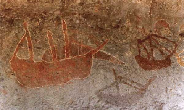
Aboriginal cave drawings (above) are to be found in a cave overhang on Flinders Island in Princess Charlotte Bay in far north Queensland. Some of the boats depicted in these drawing are clearly reminiscent of Chinese junks. The art seems to support Menzies’ theory. Menzies cites several stone structures in and around Sydney and Newcastle as further evidence of pre-European contact with Australia by the Chinese. On page 203 of his book, Menzies writes of the ‘Chinese’ ruins in Bittangabee Bay. However significant research on this site has been conducted by Michael Pearson, former Historian for the NSW Parks and Wildlife Service, who has identified the ruins as having been built in the early 1840s as a store house by the Imlay brothers, early European inhabitants, who had whaling and pastoral interests in the area. On page 220 there is the claim that “A beautiful carved stone head of the goddess Ma Tsu … is now in the Kedumba Nature Museum in Katoomba.” In fact no such museum currently exists. There once was a curio stand in Katoomba called “Kedumba Nature Display” but it closed down in the 1980s.
In Chinese Premier Hu Jintao’s speech to Austrailian Parliament on 24th October 2003, he stated: “Back in the 1420s, the Expeditionary Fleets of China’s Ming Dynasty reached Australian shores. For centuries, the Chinese sailed across vast seas and settled down in what they called “Southern Land”, or todays Australia. They brought Chinese culture to this land and lived harmoniously with the local people, contributing their proud share to Australians economy, society and its thriving pluralistic culture.”
A Chinese Shou Lao figure that pre-dates European settlement was discovered at the base of a banyan tree at Doctor’s Gully, near Darwin Port in 1879. Historians believe it’s possibly from the second half of the 19th century. The artefact, known as ‘Shou Lao’, is now housed in the Powerhouse Museum in Sydney. A group of workmen made the discovery in the 1800s while cutting down the tree to make way for a road, finding the figurine wedged amongst its roots. One theory speculates it most likely came with the Makassans who had contact with China. But others dispute that, because trepangers did not usually come to Darwin, and they argue it was more likely to have been left by local Chinese people already in Darwin.
By Rex Gilroy, Australasian Post, May 1, 1986
Aboriginal paintings depict Chinese junks … Ancient Chinese writings describing apparent Kangaroos. These facts are just part of the evidence suggesting “accepted” theories on the discovery of Australia could well be wide of the mark.
Were the Dutch explorers really the first discoverers of Australia? Or was it the Spanish or Portuguese; or far earlier mariners from Asia, the near or middle-east? As a field-researching historian, I have gathered far too much evidence to ever make me accept that old out of date hypothesis that Captain Cook discovered Australia. Take, for example, the remains of an ancient shipwreck claimed to be a Phoenician trireme at least 2500 or more years old and which was located near King Sound, Western Australia, some years ago by the late Perth diver Allan Robinson.
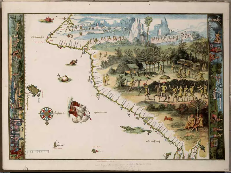
“First map of Australia” by Nicolas Vallard. Originally drawn in 1547 it is claimed this map shows the east coast of Australia with south orientated to the top.
Perhaps it might help explain the presence of apparent middle-east racial features among local Aboriginal tribes of the nearby Kimberleys region. There is plenty of evidence to indicate that traders and mineral-seekers from the middle eastern civilisations were sailing Australian waters up to 3000 years ago. But what of the ancient Chinese who were trading in these same waters at least 2500 years ago? Evidence is accumulating to prove that they too played their part in the discovery of Australia.
The Javanese, with whom the Chinese traded, had an extensive knowledge of our waters, and could have been instrumental in directing Chinese explorers to our shores. Like the earlier civilisations of the near and middle-east, the Chinese certainly possessed often enormous wooden ships and navigation aids to enable them to undertake world wide voyages in antiquity. For example, some of their huge junks were capable of carrying over 1000 people each. One type of huge junk measured at least 140 metres from bow to stern and more than 30 metres across the beam.
Between the fifth and eighth centuries the Chinese invented paddle-wheel operated vessels operated by slaves working treadmills inside the ships. By the 12th Century, they were building huge war ships with up to 23 paddle-wheels on each ship. A 15 metre rudder of one of these massive ships has in recent years been unearthed on the coast of China. It is now preserved in a Peking museum.
According to ancient writings, preserved in China, a Buddhist monk, Fu Shai in 458 A.D. may have landed in southern California after an 11,000 km voyage in one of these enormous ocean-going boats. Another Chinese explorer, Shu Shan Gee is credited with having visited the same coastline about 1000 years before Columbus “re-discovered” America. However, unlike the later European explorers, the Chinese were less interested in establishing permanent colonies in far-flung places than in establishing temporary colonies solely for the purpose of trade, or for mining of precious minerals and stones they shipped home to China.
It was Franciscan missionaries who went to China in the 16th century who were the first Europeans to obtain evidence pointing to Chinese contacts with Australia. This evidence included copper scrolls written by the Chinese in the 6th Century A.D., including a crude map of Australia. These scrolls are still being translated. They tell of such things as voyages across the Pacific Ocean in the 10th and 11th centuries in gigantic fleets of junks-60 to 100 ships carrying up to 200 or more crewmen each.
It is obvious the Chinese possessed considerable knowledge of Australia, as evidenced by their ancient writings. For example, Confucius in his “Spring and Autumn Annals” {481 B.C.} records two solar eclipses having been observed by Chinese astronomers, possibly in Arnhem Land – one {by modern calculation} on April 17, 592 B.C.; and the other on August 11, 553 B.C.
Another record, “Atlas of Foreign Countries”, written between 265 and 316 A.D., describes the far north coast of the mysterious great south land as being inhabited by a race of one-metre tall pygmies-an obvious reference to the pygmy-sized Aboriginals identified by Australian anthropologist Norman B. Tindale in the mountains above Cairns, Queensland.
In 338 B.C., Shih Tzu wrote of the presence of apparent kangaroos kept in the Imperial Zoo in Peking, and further similar reports continued in several later dynasties. Emperor Chao about this time dispatched a fleet of junks with orders to return with marsupials from the southern land of “Chui Hiao”, and a Chinese book “The Classics of Shan Hai”, written some time before 338 B.C., describes our Aboriginals and thier use of the boomerang.
The Chinese appear to have been wary when having to navigate through Torres Strait. Many ancient Chinese expeditions through the Strait came to grief due to the dreaded Torres Strait Islanders who, until early in the 1900’s, were head-hunting cannibals. In fact, the islanders regarded Chinese as being just about No1 for flavour, as they found them nowhere as salty as white men.
Ancient relics are further proof of Chinese visits to our shores. In 1948 fragments of Ming period {14th Century} blue and white porcelin were dug up on Winchelsea Island, north west of Groote Eylandt; and a large copper urn of this age was unearthed in Arnhem Land some years ago. Aboriginal cave paintings of the Arnhem Land and the Kimberleys region include depictions of Chinese junks dating back hundreds of years.
The remains of an ancient vessel, found off the coast of Perth some years ago by the late skin diver Allan Robinson, is said to have revealed relics suggesting the wreck to be that of a 12th Century Chinese Junk. At another site on the coast of the Gulf of Carpentaria near the base of Cape York, Queensland, a number of Chinese porcelin tea cups dating 2000 years were dug up several years ago.
In 1961 a 2000-year old vase bearing a crude map of the Australian east coast was discovered in Hong Kong. Another map, dating back 2000 years and drawn on porcelin, exists in Taiwan. it shows the southern coastline of New Guinea, the east coast of Australia as far south as the Melbourne area, and the crude outline of Tasmania. Another Porcelin map has since been found in China. Dating to 1477, it not only describes much of the American west coast, but some Pacific Islands, including New Zealand, Australia and New Guinea, and the islands of south-east Asia and the coast of China.
In the late 1940’s a discovery proving ancient Chinese voyages into the west Pacific region was made by a team of anthropologists while researching in the Yasawa Islands to the west of Fiji. The men found an ancient copper mine cut into a hillside. Littering surrounding rocks they found numerous centuries-old letterings. Natives on the island were later found to possess Asian racial features. They say the island was visited by a race of “yellow men” long before the coming of the Europeans.
Thirty-five years ago a jade Buddha was unearthed near Cooktown in far north-Queensland, deep below ancient soil deposits. And at Darwin in 1879 workmen dug up a statue of Shou Lao, the Chinese god of longevity, from deep down beneath the roots of an ancient banyan tree. Dating from the Ming period, it has been linked with an expedition believed to have been made to our shores by Admiral Cheng Ho on the orders of his emperor. The fleet consisted of 62 nine-masted ships, 140 metres in length, and it was accompanied by 28,000 men.
Cheng Ho {1385-1440} also possessed the magnetic compass on this voyage. Invented by the Chinese in 1090, it was not “discovered” in western Europe for another 100 years. Cheng Ho sailed from Shanghai in 1405 with orders to visit the islands of south-east Asia on diplomatic and trade matters. He was also instructed to establish a colony in the vicinity of present-day Darwin while astronomers accompanying the expedition carried out observations of the southern skies. He was also asked to make offerings here to to the Celestial Spouse, a Taoist goddess who watched over mariners at sea.
During Cheng Ho’s stay near Darwin some of his men are said to have explored deep inland, and part of his fleet is claimed to have carried out the circumnavigation of Australia before returning to China. About 1980 a young woman unearthed a carved stone head from a sand hill while walking on a beach north of Milton on the New South Wales south coast. The head, now resting in my Kedumba Nature Museum, Katoomba {NSW}, is of a Chinese goddess, possibly the “Celestial Spouse” herself.
Could the carving have been left behind by Chinese mariners centuries ago, perhaps as an offering to the goddess for a safe voyage home? Could they have been members of Cheng Ho’s fleet? The Answer is lost in the mists of time.