


Officially, there is no centre of Australia. This is because there are many complex but equally valid methods that can determine possible centres of a large, irregularly-shaped area – especially one that is curved by the earth’s surface. The following are some of the ways in which the centres of Australia, its states and territories have been determined.
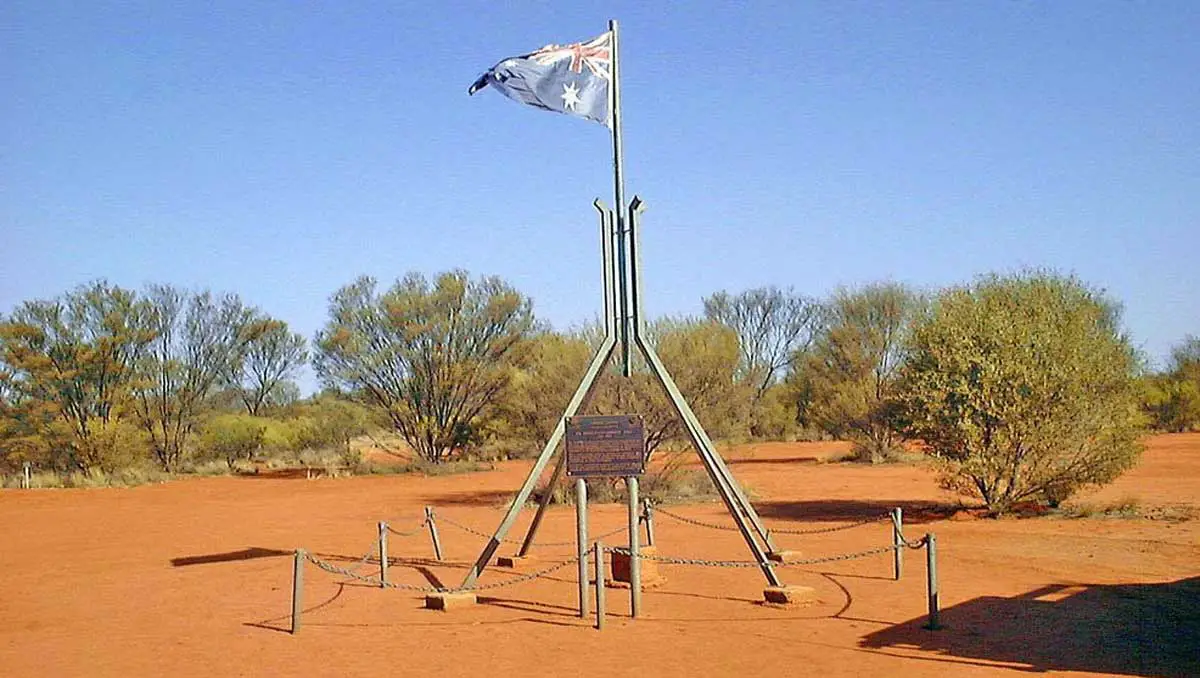
Lambert Centre
In 1988 the Royal Geographical Society of Australasia determined, as a Bicentennial project, the geographical centre of Australia. A monument was erected to mark the location and named in honour of Bruce Lambert, a former Director of the Division of National Mapping, for his achievements in the national survey, levelling and mapping of the continent. Similar to the centre of gravity method, the location was calculated from 24 500 points at the high water mark of Australia’s coastline. The computed result of the 1988 project was: 25° 36 minutes 36.4 seconds south latitude, 134° 21 minutes 17.3 seconds east longitude.
Furthest Point From The Coastline
To determine this, a series of concentric circles drawn on transparent material were moved over the top of a 1:5 million scale map of Australia until one circle was found to touch the coast at three points. Think of it as the largest perfect circle that could be drawn anywhere inside Australia that only just touches the coastlines. The centre of the circle was then marked and the coordinates scaled from the map. This method resulted in a good agreement with the centre of gravity procedure.
That location is 23° 2 minutes south latitude, 132° 10 minutes east longitude; position on SF53-13 Hermannsburg 1:250,000 and 5351 Glen Helen 1:100,000 scale maps.
Median Point
The median point was calculated as the midpoint between the extremes of latitude and longitude of the continent. Basically what this means is that a box was drawn around Australia, just touching the northern, eastern, southern, and western-most points on the continent. Lines were then drawn from the diagonals, with the intersection giving the following coordinates below. What’s interesting though is this; both this method and the furthest point from the coastline method produce coordinates that are within the ball-park of the other weighted methods. That means that despite the irregular coastline, Australia’s distinctive shape actually has a relatively high degree of symmetry.
Median Point: 24° 15 minutes south latitude, 133° 25 minutes east longitude; position on SG53-01 Henbury 1:250,000 and 5549 James 1:100,000 scale maps.
Johnston Geodetic Station
This trigonometric survey cairn, situated about one kilometre north of Mt Cavenagh Homestead, was built by officers of the Division of National Mapping in December 1965, and was once the central reference point for all Australian surveys. It was named after Fredrick Marshall Johnston, former Commonwealth Surveyor General and the first Director of National Mapping. Today, surveys are based on the Geocentric Datum of Australia (GDA), a new and more accurate Australian coordinate system which has replaced the Australian Geodetic Datum (AGD) of which the Johnston station is a major part.
Location: 25° 56 minutes 49.3 seconds south latitude, 133° 12 minutes 34.7 seconds east longitude; position on SG53-05 Kulgera 1:250,000 and 5546 Kulgera 1:100,000 scale maps.
Australian Capital Territory
The centre of the Australian Capital Territory has been calculated as the former site of the Honeysuckle Creek Tracking Station, approximately 35km south-south-west of Canberra. The tracking station played a leading role in the NASA Apollo missions, closing in 1981 with the end of the Skylab program. The radio telescope was dismantled and relocated to Tidbinbilla in 1983.
Location: 35° 29′ 24″ South, 149° 00′ 05″ East
Position on SI55-16 Canberra 1:250,000 and 8726 Michelago 1:100,000 scale maps.
In 1988 the Royal Geographical Society of Australasia determined, as a Bicentennial project, the geographical centre of Australia. A monument was erected to mark the location and named in honour of Bruce Lambert, a former Director of the Division of National Mapping, for his achievements in the national survey, levelling and mapping of the continent. Similar to the centre of gravity method, the location was calculated from 24 500 points at the high water mark of Australia’s coastline. The computed result of the 1988 project was: 25° 36 minutes 36.4 seconds south latitude, 134° 21 minutes 17.3 seconds east longitude.
To determine this, a series of concentric circles drawn on transparent material were moved over the top of a 1:5 million scale map of Australia until one circle was found to touch the coast at three points. Think of it as the largest perfect circle that could be drawn anywhere inside Australia that only just touches the coastlines. The centre of the circle was then marked and the coordinates scaled from the map. This method resulted in a good agreement with the centre of gravity procedure.
That location is 23° 2 minutes south latitude, 132° 10 minutes east longitude; position on SF53-13 Hermannsburg 1:250,000 and 5351 Glen Helen 1:100,000 scale maps.
The median point was calculated as the midpoint between the extremes of latitude and longitude of the continent. Basically what this means is that a box was drawn around Australia, just touching the northern, eastern, southern, and western-most points on the continent. Lines were then drawn from the diagonals, with the intersection giving the following coordinates below. What’s interesting though is this; both this method and the furthest point from the coastline method produce coordinates that are within the ball-park of the other weighted methods. That means that despite the irregular coastline, Australia’s distinctive shape actually has a relatively high degree of symmetry.
Median Point: 24° 15 minutes south latitude, 133° 25 minutes east longitude; position on SG53-01 Henbury 1:250,000 and 5549 James 1:100,000 scale maps.
This trigonometric survey cairn, situated about one kilometre north of Mt Cavenagh Homestead, was built by officers of the Division of National Mapping in December 1965, and was once the central reference point for all Australian surveys. It was named after Fredrick Marshall Johnston, former Commonwealth Surveyor General and the first Director of National Mapping. Today, surveys are based on the Geocentric Datum of Australia (GDA), a new and more accurate Australian coordinate system which has replaced the Australian Geodetic Datum (AGD) of which the Johnston station is a major part.
Location: 25° 56 minutes 49.3 seconds south latitude, 133° 12 minutes 34.7 seconds east longitude; position on SG53-05 Kulgera 1:250,000 and 5546 Kulgera 1:100,000 scale maps.
The centre of the Australian Capital Territory has been calculated as the former site of the Honeysuckle Creek Tracking Station, approximately 35km south-south-west of Canberra. The tracking station played a leading role in the NASA Apollo missions, closing in 1981 with the end of the Skylab program. The radio telescope was dismantled and relocated to Tidbinbilla in 1983.
Location: 35° 29′ 24″ South, 149° 00′ 05″ East
Position on SI55-16 Canberra 1:250,000 and 8726 Michelago 1:100,000 scale maps.