|
|
 |
|
INDEX
WHO DID DISCOVER AUSTRALIA?
COLONIAL EXPLORATION
|
Dutch Exploration: Discoveries and Encounters 1620-1650 | 1606 - 1619 | 1650 onwards Hessel Gerritsz (Leeuwin) 1622 Three years after Houtman first marked the Abrolhos Islands on his chart in March 1622, the company of the ship Leeuwin made land contact further south than had Houtman. They encountered what is the most southwestern prominance on the continent of Australia. The visitors described the land they found as low-lying, with sandy dunes, and called it Leeuwin Land. Hessel Gerritsz' 1627 Caert van't Landt van d'Eendracht (Chart of the Land of Eendracht), which was drawn from the findings of the crew of the Leeuwin, appears to show the coast between present-day Hamelin Bay and Point D’Entrecasteaux. Cape Leeuwin, which would be named after the vessel by Matthew Flinders on 7th December 1801 cannot be recognised, however. Other explorers to sight the cape before the area was settled in 1830 include Francois Thijssen in the Gulden Zeepaard (1627); Louis Francois Marie Alesno de St Allouarn in the Gros Ventre (1772); Nicolas Baudin 27th May 1801), who named Cape Leeuwin as Cape Gosselin, but it was not adopted. Related websites: Leeuwin Van Rosenberg (Wapen Van Hoorn) - 1622 In the same year that the British ship Trial ran aground and broke up, the Dutch VOC ship Wapen van Hoorn was almost shipwrecked on the west coast of Australia. Wapen van Hoorn was a wooden fluyt with a tonnage of between 400 and 600, built in the Dutch Republic in 1619. During its second voyage it grounded on the west coast of Australia, making it about the tenth Dutch ship to make landfall on Australian soil. It departed Texel for Batavia on 26th December 1621. In June 1622 "at night in a hard wind", the ship ran aground near Shark Bay. It was eventually refloated, and arrived in Batavia on 22nd July 1622. The vessel departed Batavia under Captain Pieter Gerritsz. The English East India Company's Trial is the earliest known ship to have been wrecked in Australian waters. Under the command of John Brooke, it struck a reef near the Montebello Islands off Western Australia's Pilbara coast on 24th May 1622, just 28 days before the Wapen van Hoorn was almost shipwrecked some 800 km to the south. Brooke and nine others escaped the wreck in a skiff, while another 36 managed to get away in the longboat, leaving the remaining 93 crew-members to perish. With a meagre supply of water, bread and wine, both groups independently made their way north-west to Java, with the longboat under the command of Thomas Bright. Brooke's skiff arrived in Batavia on 5th July 1622, Bright arrived three days later. The Wapen van Hoorn arrived in Batavia two weeks later. In 1627, the Wapen van Hoorn, under the command of David Pieterszoon de Vries and on its third voyage to Batavia, made another landfall at Shark Bay on its way to Batavia. As a result, Hartog’s chart of the region was revised. The vessel remained in the East Indies from then on. Carstenz (Pera and Arnhem) 1623 The British ship Trial ran aground and broke up in the Monte Bello Islands group in June 1622. Its crew arrived in Batavia and related the story of running hard aground during the night in the longitude of the western edge of Java at 20 degrees 10 minutes south latitude. Subsequent maps charted rocks in that locale, but such rocks have never been found there as they had incorrectly determined the exact position of the wreck. The incident served to support action already underway by the Directors of the Dutch East Indies Company to more accurately chart the coast of New Holland. To this end, Herman van Speult, the Governor of Amroyna, commissioned Jan Carstensz, with fellow explorer Van Colster, to sail two ships, the Arnhem and Pera, with the aim of expanding on the reports from the Duyfken, again sailing the southern coast of New Guinea and the region of the west coast of Cape York (believed to be a continuance of New Guinea). Furthermore, Carstenz was directed to carry out the broad instructions of an earlier, non-starting Dutch exploration to the area, to ascertain as much of the situation and nature of these regions as possible.
Soon after turning at the Staaten River, the mutinous crew of the Arnhem left Carstenz. The Pera continued gathering what information it could about the peoples and the potential trading commodities along the coast, but none of the information was optomistic to the trading interests of the Company. Carstenz returned to Amboyna on 6th June, expecting the Arnhem to have abandoned the mission and made for pleasurous ports. This apparently was not true. Following separation from the Pera, the Arnhem was blown west across the unproven and as yet un-named Gulf of Carpenteria, making land on the east-facing shore of the opposite side. From there, she explored north and west across the top of the region that is called Arnhem Land after their vessel, before returning to home. Related websites: Jan Carstensz | map of Gulf of Carpentaria dated 1646, based on information collected by various Dutch expeditions between 1606 and 1646 Hermanszoon (Leijden) 1623 Captain Claes Hermanszoon in the VOC ship Leyden charted further regions of the west coast south of Shark Bay. The ship's journal records the first European baby born in Australian waters during this voyage. Tortelduiff 1624 The ship Tortelduyf sighted Tortelduyf Shoal off the west coast south of the Houtman Abrolhos. The shoal first appeared on charts by the Dutch East India Company's cartographer, Hessel Gerritz, in 1628, and was named after their ship. Thijssen (Gulden Zeepaert) 1627 In 1622 that the Governor General of Dutch East Indie, Jan Pieterszoon Coen, made plans and gave instructions for a thorough investigation of the South Land. He wanted 'to ascertaining as much of the situation and nature of these regions as God Almighty shall vouchsafe to allow'. In 1627 the crew of the Gulden Zeepaerdt, under the command of Francois Thijssen, touched the most southerly part of the continent and sailed east as far as present day Ceduna. 1,800 km of Australia's south coast were traversed and mapped, between Cape Leeuwin and Nuyts Archipelago. The land was named Pieter Nuytsland, after one of the 220 passengers on board, Pieter Nuyts, an esteemed councillor of India who planned to settle in Java. Two of the islands discovered were named St Peter and St Francis on what became Australia Day (26th January) 1627. Later, both French and English navigators, including Matthew Flinders, praised the accuracy of the Dutch mapping, the first of any part of the southern coast. They are now the oldest place names in South Australia. Not finding anything of their liking or to trade, most of the Dutch soon lost interest in New Holland and very few thought of colonising it or establishing a small foothold or port. However on 20th May 1717, Jean Pierre Purry, who had been working for the Dutch East Indie Company (VOC) tried to convince the Governor of Batavia that a colony should be established in Nuytsland. He came up with several good reasons but was unsuccessful. When back in Holland he put together a small book on the subject, which was published in Amsterdam in 1718. Although unsuccessful, once again the ideas were not forgotten altogether. It was on the basis of the maps drawn by Nuyts that Jonathan Swift, when writing Gulliver's Travels, located the land of the Houyhnhnms almost exactly at the present site of Albany in Western Australia. With some kind of extraordinary vision Swift had Gulliver land on the coastline, eat oysters and be chased by Aborigines. He could not have known that George Vancouver, some 65 years later, would enter one of the bays of King George Sound and name it Oyster Harbour because of the abundance of oysters he found in the area. It stands to reason that perhaps the Gulden Zeepaerdt had also visited King George Sound and experienced life there 65 years before Vancouver. Related websites: François Thijssen | Pieter Nuyts | Pieter Nuyts Galias (Etrecht) 1627 Commander Jan Pieterszoon Coen, who was later to become Governor-General of the East Indies, charted land on the west coast at Latitude 28°30'S in the VOC ships Galias, Utrecht and Texel. He later stressed the importance of accurate charting to the Directors of the VOC. Willem de-Witt, (Vianen) 1628 In 1628 the ship Vyanen almost ran aground on the northwest coast in the lattitude of about 21 degrees. To save the ship, she was lightened of casks of pepper and quantities of copper. After standing off the rocky coast, the Vyanen followed it for 320 km, but there was nothing which caused the ship's company to record promise. The region followed was subsequently called G.F. de Witts Land. De Witt reported it "a foul and barren shore, green fields. and very wild, barbarous inhabitants." Pelsaert (Batavia) 1629
Cornelis and his undisciplined and drunken crew were less than completely successful in off-loading all the fresh water, supplies and persons of the ship. On these islands there was very small amount of water and it was decided by commander Francis Pelsaert that he should take the ship's small boat with sail and make a search for water. Pelsaert was able to make the coast of the continent, but in his northward search, he was unable to find fresh water. A rising northeast wind caused Pelsaert to be unable to continue along the coast, so he decided to make for Batavia, which he reached in early July. In Batavia Pelsaert was given charge a large ship, the Sardam, to return to recover his marooned charges. It was with relief on his approach to the locale, that he observed smoke rising from the small islets. He was soon treated to a story of mutinous intrigue that was continuing to play out as he arrived. Two small boat approached the Sardam from different islands - in one was Jerome Cornelis, fuly armed and dressed in flowing robes. In the ther was a midshipman named Weybe Hays, who warned Pelsaert of the danger of his position. Hays reached the Sardam first and quickly relayed the story of the previous three months - Cornelis had landed on the larger of the two islets, and resumed his planned conspiracy of piracy which had begun in distant waters off the coast of Africa before the shipwreck. Cornelis had established a group of co-conspirators and set about systematically killing the women and children and all the men who disagreed with his mutinous plot. In the meantime, Hays had been sent to a third island as much to get him out of the way as to search for water. Cornelis never expected Hays to find water and believed he would soon perish, but the search was successful and from that island Hays signalled for the others to come. Cornelis ignored the signal, and instead launched an attempt to subdue Weybe Hays and his band of 45 men. Though unarmed, Hays and his group were able to repell Cornelis on two occasions. A buy-off of Weybe Hays' men by Cornelis also failed.
Related websites: François Pelsaert | Batavia | alternate | VOC shipwrecks (Grooten Broeck) 1631 The VOC ship Grooten Broeck sailed along the west coast from Cape Leeuwin to Dirk Hartog Island on the way to Batavia. Dirckszoon (Amsterdam) 1635 The VOC ship Amsterdam under the command of Woolebrand Geleynszoon de Jongh charted the west coast around the latitude of Shark Bay. Pool (Klein Amsterdam / Wesel) 1636 The Dutch had pieced together much of the picture of a continental south land, but the spotty discoveries created many questions about the geography and the potential trading value of the regions below the Indo-West Pacific archipeligo. An ambitious plan for exploration of the great lands was set forth and command given to Gerrit Pool in 1636. Early in the expedition, Pool was killed and the expedition was abandoned, though not before they contacted the region west of the Arnhem discoveries in and around the region of currently named Melville Island. Related websites: map of Gulf of Carpentaria dated 1646, based information collected by various Dutch expeditions between 1606 and 1646 Tasman (Heemskerch / Zeehan) 1942
Intending to sail eastward at the southern latitude of 52 or 54 degrees, it became evident early on that weather would not permit this. It was decided to sail along the 44th and 40th parallels and as the two ships reached the longitude of the islands of St Peter and St Francis on the South Australian coast, then travelled further south, sighting Tasmania on 24th November 1642. Tasman named the island after the governor of The Dutch East Indies, Antonio van Diemen. The first two mountains they sighted on the island were named Mount Zeehan and Mount Heemskirk, after their ships. Variable weather made exploration of the eastern coast of Van Diemen's Land difficult. Seeking shelter in a large bay, Tasman put into a cove to shelter from a storm. He called the location Storm Bay. A later explorer (Furneaux) misread Tasman's notes and called this bay Adventure Bay and a larger bay nearby was erroneously marked on Furneaux's charts as Storm Bay. On 1st December, the storm having abated, the ships were able to move on before coming to anchor at Green Island. They put ashore for supplies at what is now known as Blackman Bay (north of Bruny Island). Two days later, the carpenter, Peter Jacobsen, volunteered to swim ashore with a pole on which was the Prince's flag, which he planted on the shore of the bay. Thus Tasman took possession of the island for the Dutch. Not finding enough good water, Tasman moved on and continued his search, traversing the east coast of Tasmania. When the shore fell away to the northwest (Bass Strait) and the weather was coming in directly from the north, Tasman decided to quit this island and continue east, sailing on to the south island of New Zealand. Related websites: Abel Janszoon Tasman | Heemskerch Tasman (Limmen,/ Zeemeeuw / Braq) 1644
Related websites: Abel Janszoon Tasman | map of Gulf of Carpentaria dated 1646, based information collected by various Dutch expeditions between 1606 and 1646 Jan Janszoon Zeeuw (Leewerk) 1648 Zeeuw in the VOC ship Leeuwerik charted the west coast, weather conditions permitting, on his way north to Batavia. Further exploration and encounters: 1650 onwards RELATED WEBSITES
|

 In January 1623 these ships sailed from Amboyna and to the coast of New Guinea. Coasting easterly, Carstenz was not able to make good report of the area's fruits and minerals, but did note the natives were "belligerent and cannibalistic". At one point the captain and several of the crew of the Arnhem were killed by natives. Carstenz proceeded to the region of Torres Strait and concluded that this maze of reefs and shallows (as he moved east) could be nothing but a westward opening bay, even though a chart he was carrying indicated the high possibility of an opening to the greater Pacific. He retracked to the west, then south along the west coast of Cape York, similar to the route the Duyfken travel. Carstenz continued past Cape Keer-Weer, the turning point of the Duyfken, but at the Staaten River (right) his concern of being trapped against a southern bay by a north breeze caused him to turn north again.
 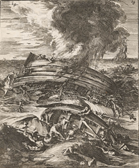 The Dutch had pieced together the features of nearly all the continent's coastline westward from Cape York, around to the south of St Peter and St Francis islands by 1629, but much of it had been inaccurately and incompletely charted. One of the most treacherous sections was very near to the recommended continental contact point before turning north - Houtman's Abrolhos. In the night of 4th June 1629 the flagship of the VOC fleet, the Batavia, on her maiden voyage, stuck fast on a reef of the Abrolhos Islands. Attempts by its commander Francis Pelsaert, to lighten the ship and escape the reef were thwarted by rising wind and rain and tangles of incompletely cut away rigging. When it was realised the ship was doomed, a hurried attempt was mde to find land for the women and children and sailors aboard. Two small rocky islets were clear at high tide, and further distant appeared a more substantial island, so many persons were discharged onto the islets, but 70 people remained aboard the disintegrating Batavia. The ship's supercargo Jerome Cornelis was left on board and given orders to help the 70 to safety.
  Cornelis' men came alongside Pelsaert's ship armed, and requested to board. Pelsaert demanded the pirates lose their weapons and as they were brought on board, each was placed in irons. Most of the jewels and silver from the wrecked Batavia were recovered, and Cornelis and his men were condemned by a hastily conducted court. They were hung and Pelsaert left the Abrolhos with the remaining survivors. Travelling north along the mainland's coast near the site of present day Kalbarri, Pelsaert condemned two of the criminals - Wouter Loos and Jan Pelgrom de Bye - to be marooned, in the hope they may be rescued alive in the future and thus gain some knowledge of the area. They were never seen or heard of again.
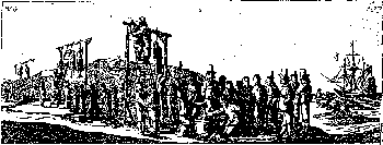
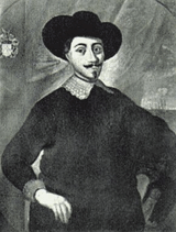 On 2nd June 1639, Abel Janszoon Tasman was dispatched by Antonio van Diemen (right), Governor-General of the Dutch East Indies, on "a voyage to the north-western Pacific, in search of certain Islands of gold and silver, east of Japan". On this voyage Tasman was to visit the Philippines and improved Dutch knowledge of the east coast of Luzon. He did this, and also discovered and mapped various islands to the north. Tasman was also engaged in several other trips, sailing to Formosa, Japan, Cambodia and Palembang as a merchant captain until 1642. In 1642 he set out on the first of his two New Holland expeditions. The expedition left Batavia on 14th August 1642 with two vessels, the Heemskerk with a 60-man crew and the Zeehaan with 50 men on board. They first called at Mauritius, where they stayed for a month long repair to both ships.
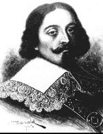 The first white man to have seen Sweers Island and the southern shores of the Gulf of Carpentaria was most likely Abel Tasman (right) in June or July 1644, Tasman had been the first European to explore the shores of Tasmania two years earlier. He had been sent by the Dutch Governor-General with three ships, the Zeemeeuw, Limmen and Bracq, to determine whether a strait existed between New Guinea and New Holland as shown on Franco-Portuguese maps. Tasman failed to find Torres Strait, probably because he sailed too far offshore, however he did map the north coast of Australia, making observations on the land and its people. The dissatisfaction with Tasman's voyage is best reflected in that a further exploratory expedition was sent to the same area with almost identical orders in 1756. Although rebuked by the directors of the Dutch East India Company for unremunerative exploration - "Why bother about barren and remote countries inhabited by wild and unprofitable savages?" - Tasman's rank of commander was confirmed and, in November 1644, he was appointed to the Council of Justice in Batavia. In May 1648 he was in charge of an expedition sent to Manila to try to intercept and loot the Spanish silver ships coming from America, but he had no success and returned to Batavia in January 1649. Later that year he was charged and found guilty of having in the previous year hanged one of his men without trial, was suspended from his office of commander, fined, and made to pay compensation to the relatives of the sailor. Tasman retired from the Company in 1651, becoming a wealthy merchant until his death in 1659.