|
The Discovery of Australia: Naming Australia's Coastline
Tasmania
Cape Portland
1.11.1798. Flinders. Named after the Duke of Portland, Secretary of State for the Colonies.
Foster Isld
1.11.1798. Flinders.
 Ringarooma Bay (right) Ringarooma Bay (right)
Believed to be an Aboiriginal name. This name is said to have been used by the north east tribes to designate eastern parts of Cape Portland, including a bay, a point and offshore islands, 'Ring er roomer' meaning swift water point.
Waterhouse Pt / Waterhouse Isld
1.11.1798. Flinders. Named after Henry Waterhouse, master Relience, who brought the first merino sheep to Australia.
Croppies Pt
Croppies are people who work in fields. How the name came to be given is not known.
Anderson Bay
Named after Joseph Anderson (1790-1877), military officer.
East Sandy Cape
1.11.1798. Flinders. Decriptive.
West Sandy Cape
1.11.1798. Flinders. Descriptive.
Ninth Isld
1.11.1798. Flinders. Ninth rocky island discovered.
Noland Bay
Stony Head
1.11.1798. Flinders. Its appearance.
Five Mile Bluff
Descriptive.
Tenth Isld
2.11.1798. Flinders. Tenth rocky island discovered.
Low Head
3.11.1798. Flinders. Being a low sandy projection.
 West Head West Head
3.11.1798. Flinders. its location in relation to the entrance to Port Dalrymple.
Port Dalrymple
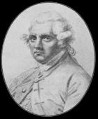
1.11.1798. Flinders. Named after Alexander Dalrymple (right), hydrographer to the British Navy.
Bell Bay
Named after Major Bell, C.B. Superintendent of 48th regiment, Acting Engineer and Inspector of Public Works at Hobart Town.
Badger Head
Port Sorrell
12.1.1819. King. Named after William Sorrell, Lieut Governor, Tasmania.
River Mersey/Mersey Bluff
Recalls the River Mersey in Liverpool, England.
Emu Bay
Emus were common there when early settlers arrived.
Table Cape
1.11.1798. Flinders. Its appearance, a steep, cliffy head with a flat top (it is the core of an extinct volcano).
Rocky Cape
5.12.1798. Flinders. Its appearance.
Sawyer Bay
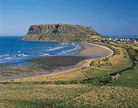 Circular Head (right) Circular Head (right)
5.12.1798. Flinders. Shaped like a christmas cake (it is the core of an extinct volcano).
Highfield Pt
Half Moon Bay
Descriptive
North Pt
Descriptive of the point's location.
West Pt
Descriptive of the point's location.
Perkins Bay / Perkins Isld
Named after early settler and land grantee, James Perkins.
Robbins Isld / Robbins Passage
Named after Charles Robbins, master, Buffalo, 1804.
Cape Elie
Gutyon Pt
Ransonnet Bay
4.2.1802. Baudin. Named after Joseph Ransonnet, engineer, Geographe.
Walker Isld
Petrel Isld
Petrels seen there.
Henderson Islets
Three Hummock Isld
9.12.1798. Flinders. Its appearance.
Cape Rochon
Thought to be named after Rosette Rochen, a free woman of colour, who was born a decade before the American Revolution in about 1767 in Mobile, Alabama. She died in New Orleans during the Civil War at a very advanced age in 1863. She grew to be a successful entrepreneur, a landowner, a grocer, and a financier. She made a contribution of unquestioned importance to the neighborhood, the city, and Creole culture.
Cape Adamson
Coulomb Bay
25.2.1802, Baudin. Named after Charles Augustin Coulomb (1736- 1806), Fench mathematician.
Hunter Islds Group / Hunter Isld
10.12.1798. Flinders. Named after John Hunter, Governor, New South Wales. Unaware that it had already been named by Flinders, Baudin named it Fleurieu Island in 1802 but this name was never adopted or used.
Cape Keraudren
25.2.1802, Baudin. Named after Pierre Francois Keraudren (1769-1858), Medical inspector of the French Navy.
Three Hummock Islands
9.1.1802. Murray. Descriptive.
King Island
1.1.1801. Black. Named after Philip Parker King, Governor of New South Wales.
Stokes Pt
25.11.1838. Wickham. Named after John Lort Stokes, Lieutenant and Assistant Surveyor, Beagle.
Surprise Pt
11.1.1802. Murray.
Cataque Pt
February 1802, Baudin.
Fitzmaurice Bay
29.11.1838. Wickham. Named after L.R. Fitzmaurice, surveyor and ship's mate, Beagle.
Waterwitch Reef
29.11.1838. Wickham. Named after the sailing cutter Waterwitch which travelled the ports of the Australian coastline in the 1830s and 1840s.
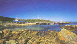 Currie Harbour (right) Currie Harbour (right)
Capt. Archibald Currie. The ship Netherby ran onto rocks, south of the harbour mouth in 1866, and was taken into the harbour for salvaging by Currie. The harbour and later the settlement were named in his honour.
Whistler Pt
29.11.1838. Wickham.
New Year Isld
1.1.1801. Black. Rounded on New Years Day.
Phoques Bay
January 1802, Baudin. French for Seal Bay.
Cape Farewell
26.1.1802. Murray. Expedition left the coast here.
Cape Wickham
30.11.1838. Wickham. Named after John Clements Wickham, expedition leader of HMS "Beagle". Wickham's made a major contribution yo surveying various coasts of Australia from 1838 to 1840, including the north west coast in the vicinity of Wickham. Wickham was born in Scotland in 1798, and joined the Royal Navy as a midshipman in 1812. From 1831 to 1836 he sailed on the Beagle's voyage around the world as second in charge under Captain Robert FitzRoy. Wickham was then appointed commander of the expedition to survey the coast of Australia on the "Beagle", with John Lort Stokes his second in charge. He later settled in Australia, and died in France in 1864.
Boulder Pt
17.1.1802. Murray. Large rocks found there.
Lavinia Pt
30.11.1838. Wickham. Martha Lavinia.
Sea Elephant Rock / Sea Elephant Bay
December 1801. Baudin. Numerous sea elephants blocked the passage.
Fraser Bluff
17.1.1802. Murray.
Bold Head
17.1.1802. Murray. Descriptive.
Grassy Pt
30.11.1838. Wickham. Descriptive.
Seal Pt / Seal Bay
1.1.1801. Black. A large seal colony seen here.
Reid Rock
Bell Reef
Black Pyramid
10.12.1798. Flinders. Descriptive.
Albatross Isld
10.12.1798. Flinders. Many albatrosses seen nesting there.
Trefoil Isld
10.12.1798. Flinders. Shaped like a clover leaf.
Barren Island
10.12.1798. Flinders. Its appearance.
Woolnorth Pt
Flat Topped Bluff
10.12.1798. Flinders. Descriptive.
Bluff Pt
10.12.1798. Descriptive.
Cape Grim
10.12.1798. Flinders. Its appearance.
Valley Bay
10.12.1798. Flinders. Descriptive.
Studland Bay
Calm Bay
10.12.1798. Flinders. Its appearance.
Halley Bailey
Green Pt
10.12.1798. Flinders. Its appearance.
West Pt
most westerly point on the coast.
Bluff Hill Pt
10.12.1798. Flinders. Its appearance.
Couta Rocks
Nelson Bay
The brig Lady Nelson that was based in Sydney and brought the first European settlers to Hobart. In March 1801, she was sent to re-examine Bass Strait by Governor King. On this voyage she made the first survey of Westernport Bay (Vic). From November 1801 to March 1802, under the command of Lieutenant John Murray, the Lady Nelson explored Bass Strait and most of King Island. It was on this voyage that Port Phillip was discovered and explored. From July to November of 1802, she accompanied the Investigator (under Lieutenant Matthew Flinders) north to assist in the charting of the coastline. After damaging herself on the corals of the Great Barrier Reef, she had to turn back to Sydney, necessitating Flinders to continue alone.
Temma Harbour
Richardson Pt
Hazard Bay
Ordnance Pt
Place from which a survey commenced.
Kenneth Bay
Sandy Cape
Flinders. Descriptive.
Johnson Bay
Rupert Pt
Pieman Head
Pieman Head and he Pieman River gained its name from the notorious convict Alexander 'The Pieman' Pearce who was responsible for one of the few recorded instances of cannibalism in Australia.
Hardwick Bay
Conical Point
Granville Hd / Granville Harbour
Named after George Leveson-Gower, 2d Earl of Granville, 1815-91, British statesman. He entered Parliament as a Whig in 1836 and held various cabinet positions under Lord John Russell, the earl of Aberdeen, and Viscount Palmerston. As colonial secretary (1868-70, 1886) under William Gladstone, he had a large part in passing the bills that disestablished the Church of Ireland and began reforms in Irish land tenure. He was also foreign secretary (1870-74, 1880-85) under Gladstone.
Trial Harbour
28.2.1802, Baudin. Named after Armand Emmanuel Trial (1771-1803), French composer.
Macquarie Harbour
Named after Lachlan Macquarie, Governor of New South Wales, 1810-21.
Baylee Creek
Named after Major Perry Baylee, last Commandant of Sarah Island, 1831-33.
Birchs Inlet
Named by Captain James Kelly in 1815 after merchant Thomas William Birch, who financed Kelly’s journey.
Briggs Creek
Named after Captain James Briggs, Commandant of Sarah Island, 1829-1831.
Butler Island
'Discovered' by an exploring party aboard the brig, Cyprus in 1829, the island is named after Captain James Butler, Commandant of Sarah Island, 1825-29.
Charcoal Burners Bluff
Named in reference to the charcoal burner operated by convicts from the Sarah Island penal settlement.
Elizabeth Island
Named by James Kelly in 1815 after the wife of James Gordon, who lent the whaleboat (also named Elizabeth) for Kelly’s journey.
Grummet Island
Formerly known as Condemned or Small Island, the present name may be an allusion to the shackles of the prisoners who endured confinement on this small island. A grummet is a metal ring.
Hells Gates
Believed to have been so named by convicts who passed through this narrow and treacherous waterway on their journey to the Sarah Island penal settlement.
Henty River
Named by Charles Gould in 1862 after the Colonial Secretary, William Henty.
Pillinger
Originally known as Macquarie, the once thriving town owed its name to Alfred Pillinger, Minister for Lands and Works in 1898.
Sarah Island
Named by James Kelly after the wife of merchant Thomas Birch, who financed Kelly's voyage. The island has also been known as Settlement Island. Its Aboriginal name is Langerrareroune.
Soldiers Island
Named by Commissariat Officer Lempriere in 1839, presumably in reference to its popularity as a retreat for the soldiers of the Sarah Island penal settlement.
Spero River
Named by the explorer Thomas Moore in 1879, after his dog.
Wright Point
Named after Lt. Samuel Wright, Commandant of Sarah Island, 1824-1825.
 Cape Sorrell (right) Cape Sorrell (right)
Named after William Sorrell, Lieut Governor, Tasmania.
Watts Head
Named after George Watts, an absconding convict from Coal River and bushranger in company with Sefton & Geary.
Table Head
11.12.1798. Flinders. Its shape.
Sloop Pt
Birthday Bay
Hibbs Bay / Point Hibbs
11.12.1798. Flinders. Named after Peter Hibbs, colonial master, Norfolk.
Spero Bay
Endeavour Bay
High Rocky Pt
Flinders, Descriptive.
Green Pt
Flinders. Descriptive.
Low Rocky Pt
Flinders. Descriptive.
Elliott Bay
Flinders. Named after Sir Charles Elliott, Governor of Bermuda.
Nye Bay
Mucahy Bay
Wreck Bay
Green Isld
Flinders. Descriptive.
Trumpeter Isld
Flinders. Trumpeter fish caught here.
Cape St Vincent
12.12.1798. Flinders. Named after Earl St Vincent, President of the Board of the Admiralty.
Port Davey
Named after Col. Thomas Davey, 1st Lieut. Governor, Tasmania, 1813-19.
Payne Bay
Hillard Hd
Stephens Bay
Island Bay
Mutton Bird Isld
9.3.1772. Furneaux. Descriptive of the type of birds seen in abundance here.
Window Pane Bay
South West Cape
9.3.1773. Furneaux. Its location in relation to the rest of Tasmania.
Mewstone
9.3.1773. Furneaux. rocks there resembled mewstone.
Cox Bluff / Cox Bight
Posibly named after William Cox Jnr, son of Sydney builder William Cox with constructed the first road across the Blue Mountains, NSW. Cox Jnr arrived in Hobart in 1816 and built Hobartville House in Richmond, Tas, in 1828.
Louisa Bay
Red Pt
De Witt Isld
25.11.1642. Tasman. Named after Gerritt Frederikszoon de Witt, a member of the Dutch East India Company's Council of India, which gave Abel Tasman regarding the instructions for his voyage to New Holland of 1644. In 1628, De Witt was master of the Dutch East India Company's vessel, Vyanen, which sailed along and mapped over 300 kms of the coastline of New Holland in the vicinity of present day Port Hedland, WA, in 1628. Dutch cartographers named this section of coastline De Witts Land, after him.
 Sweers Isld Sweers Isld
25.11.1642. Tasman. Named after Salomon Sweers, a member of the Dutch East India Company's Council of India. Sweers was also a member of the Council which gave the Instructions to Abel Tasman regarding his voyage to New Holland of 1644. He was born 15th June 1611 in Amsterdam. Educated as a merchant, he worked as bailiff of the island of Texel (Netherlands) in service for the counts of Holland. He later became an under merchant in India for The East-India Company (VOC) where he became ordinaris counselor as an extension of his role as the manager of one of the Dutch offices. Sweers was married in Batavia (Djakarta) on 16th August 1637 to Catrina Jansdr. On 29th November 1662, he returned to and settled in Amsterdam as a merchant. In 1664 he became the manager of the Madhouse in Amsterdam and in 1667, church master at Noorder kerk (North Church). Sweers died in Amsterdam on 2nd March 1674.
Maatsuyker Islds / Maatsuyker Isld
25.11.1642. Tasman. Named after Joan Maetsuijker (right), a member of the Council of Batavia who had sponsored the expeditions of its discoverer, Dutch navigator Abel Tasman. The Instructions to Tasman regarding his voyage to New Holland given by the Governor-General and Council of the Dutch East India Company were drawn up at Batavia on 13th January, 1644, and were signed by Anthony Van Diemen, Cornelis Van Der Lijn (Director-General), Joan Maetsuijker, Justis Schouten ("Councillor-Extraordinary to the present assembly"), Salomon Sweers, and Pieter Metschagh (Secretary). Maatsuyker was born in Amsterdam on 14th October 1606. He became a servant of the VOC in 1636 and later a secretary of the Council of justice in Batavia. In 1641 he became an extraordinary advisor of the Dutch-Indies. In this function he distinguished himself, by order of governor general Van Diemen, by adapting the existing edict, proclamations and decree's from the Heeren XVII and governor-general into a code book, the Statutes of Batavia, on which the judicial system in the Dutch-Indies was based until 1848. From 1646 till 1650, Maetsuycker was governor of Ceylon. He was governor-general of the Dutch East Indies for 25 years, from 1653 to his death in Batavia (Jakarta) on 24th January, 1678. During his regime the power of the VOC was adequately extended on Java, Sumatra and Celebes. The islands were named by Commander John Hayes as The Three Brothers. The Aboriginal name for the islands is Draywanee.
The Sisters
Hayes. A pair of islands similar to the Maatsuyker Islands.
Ile Du Golte
5.5.1792. D'Entrecasteaux. Literally means Island of the Gulf.
Prion Bay
9.3.1773. Furneaux. The bay is a breeding ground for the Antarctic prion (Pachyptila desolata) and Fairy prion (Pachyptila turtur).
Shoemakers Pt
Surprise Bay
South Cape / South Cape Bay
6.12.1642. Tasman. Charts were marked de Zuijd Cap (South Cape).
South East Cape
9.3.1773. Furneaux. Its position.
Swilly Islds
11.3.1773. Furneaux. Named after the home town of Furneaux, near Plymouth.
Whale Head
Pedra Bianca
Eddystone Rock
3.1773. Furneaux. Resembled a lighthouse, which reminded Furneaux of eddystone Lighthouse in England.
Sidmouth Rock
Recherche Bay
5.5.1792. D'Entrecasteaux. Named after the expedition ship, Recherche. A port was built here in colonial days known as Ramsgate after a town in Keny, UK. Aborigina; name: Leillateah.
Actaeon Isld
13.1.1802. Baudin. Naked native women were seen here for the first time. They were described by Peron as being in the condition in which Actaeon saw Diana, when "all undrest the shining goddess stood," though they did not, when discovered, glow with: "such blushes as adorn the ruddy welkin or the purple morn." Previously named Sterile Island by D'Entrecasteaux, 5.5.1792.
Southport Lagoon
Named Baie de Moules (Bay of Fish) by D'Entrecasteaux, 6.5.1792.
 Southport Point Southport Point
Named Point de Riche by D'Entrecasteaux, 6.5.1792 after Claud Antoine Gaspard Riche (1762-92), naturalist, Recherche.
D'Entrecasteaux Channel
6.5.1792. D'Entrecasteaux. Named after expedition leader, Bruni D'Entrecasteaux (right). Named Seton Straits by Comm. John Hayes a year later, this name was never used. Early settlers knew the channel as South West Passage.
Simpsons Point
1793. Hayes.
Bruny Island
6.5.1792. D'Entrecasteaux. Named after expedition leader, Bruni D'Entrecasteaux. Originally spelt Bruni, the name was later changed to Bruny Island. For a time Bruny Island was known as Pitt's Island, recalling the name 'Right Honourable William Pitt's Island' given to it by Commander John Hayes (later Sir John) of the East India Company, who in 1793, was the first British explorer to 'discover' and chart the River Derwent. Hayes named many coastal features in the vicinity of present day Hobart, but few are used today.
Cape Bruny
6.5.1792. D'Entrecasteaux. Named after expedition leader, Bruni D'Entrecasteaux. Originally spelt Bruni, the name was later changed to Cape Bruny.
Cloudy Bay
Named Mauvaise Bay, D'Entrecasteaux, 6.5.1792.
Gt Taylors Bay
Named Le Grand Anse (The Great Bay) by D'Entrecasteaux, 6.5.1792.
Tasman Head
Named Point La Billiardiere by D'Entrecasteaux, 6.5.1792, after Jeane de La Billiardiere, who also sailed with Baudin, 1801-03.
Boreel Head
1.12.1642. Tasman. Named after Pieter Boreel, Councillor, Dutch East India Company.
 Fluted Cape (right) Fluted Cape (right)
14.3.1773. Hayes. Its shape. Named Cap Cannele by D'Entrecasteaux, 6.5.1792.
Adventure Bay
11.3.1773. Furneaux. Named after Firneaux's expedition vessel, HMS Adventure, which was anchored there. Named Storm Bay by Tasman, 1.12.1642, as he sheltered here during a storm on previous day. Map makers incorrectly marked present day Storm Bay as the place where Tasman sheltered and the name has been retained.
Isthmus Bay
6.5.1792. D'Entrecasteaux. On the isthmus between North and South Bruny Islands.
The Firars
11.3.1773. Furneaux. Several small islands resembled the heads of bald friars.
Cape Queen Elizabeth
Named in honour of Queen Elizabeth II after a visit by her and her husband, Prince Philip, the Duke of Edinburgh. Named Cape Trobiand by D'Entrecasteaux, 6.5.1792, after Denis De Trobiard, 1st Lieut., L'Esperance. It was marked on early charts as Cape Frederick Hendrick, a name given by Abel Tasman, though not necessarily to this headland.
The Neck
Named St Aignon Isthmus by D'Entrecasteaux, 7.5.1792, after a member of his expedition who waded ashore near here naked after the accidental beaching of his boat.
Betsey Island
1793, Hayes. Previously named Willaunez Island by D'Entrecasteaux a few months earlier after one of his officers. Renamed Franklin Island after Lady Franklin bought it. The island reverted to its original name after her death.
Partridge Isld
Named Ile Aux Perdix by D'Entrecasteaux, 6.5.1792, after crew member Jean Perdix, L'Esperance.
Variety Bay
Trumpeter Pt / Trumpeter Bay
1793. Hayes.
The Yellow Bluff
1793. Hayes.
One Tree Pt
1793. Hayes.
Cape Delesorte
Egg Isld
6.5.1792. D'Entrecasteaux. Many ducks eggs taken aboard here.
Cygnet Bay
6.5.1792. D'Entrecasteaux. Cygnets and swans seen there by Huon de Kermadec's expedition up the Huon River.
Garden Isld
1793. Hayes.
Huon Pt / Huon Island / Huon River
7.5.1792. D'Entrecasteaux. Named after Huon de Kermadec, master L'Esperance, who led the expedition whicvh explored the river. Huon Isld is now known as Garden Island.
Nine Pin Pt
Oyster Pt
1793. Hayes. Oysters found in abundance here.
Snug Cove / Snug Point
Snug Point was named Point Gicquel by D'Entrecasteaux, 6.5.1792. D'Entrecasteaux. after Pierre Guillaume Gicquel Des touches, a seaman of Recherche, later captain. He also sailed with La Perouse and Baudin.
North West Bay
1793. Hayes. Descrptive of its location.
Dennes Pt
Originally named Point Jurien by D'Entrecasteaux, 6.5.1792, after the French Minister for the Navy, Charles Jurien.
Piersons Pt
6.5.1792. D'Entrecasteaux. Named after Pierson, chaplain and astronomer, Recherche.
Crayfish Pt
1793. Hayes. Many crayfish caught here.
Gellibrand Pt
1793. Hayes. Named after Joseph Tice Gellibrand, a lawyer, was a member of the Port Phillip Association which crossed from Tasmania to Victoria and took possession of the land around Melbourne and Geelong under a treaty with the native chiefs. Gellibrand prepared the treaty documents. With G. B. L. Hesse, a fellow solicitor. He disappeared in 1837 on an exploratory expedition around the Colac area on a journey from Geelong to Melbourne via the Barwon Ri ver. Williamstown was originalkly known as Port Gellibrand.
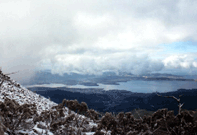 Derwent River (viewed from the top of Mt Wellington, right) Derwent River (viewed from the top of Mt Wellington, right)
1793. Hayes. Named after the geographical features of Derwentwater and the Derwent River, in the Lakes District of his native Cumberland in England. Three months earlier, d'Entrecasteaux had returned to the area to repair his ships on his return home to France and named it "Riviere du Nord" (as the river flowed from the north). The river estuary was then named Port Buache by Baudin, 4.2.1802, after Philippe Buache (1700-1773), French geographer.
Courts Bay / Island
1793. Hayes. Named after Thomas William Court, 1st Officer of one of Hayes' ships, 'Duke of Clarence'.
Risdon Cove
1793. Hayes. Named after William Bellamy Risdon, second officer of one of Hayes' ships, 'Duke of Clarence'.
Cornelian Bay
1793. Hayes.
Ralphs Bay
1793. Hayes. Named Double Bay by D'Entrecasteaux, 6.5.1792.
Northern Peninsula
8.5.1792. D'Entrecasteaux. Descriptive.
South Arm
1793. Hayes. Descriptive.
Iron Pot
Cape Direction
8.5.1792. D'Entrecasteaux. Bearings were taken here.
Hope Beach
Betsy Isld
Named ile Willaumez by D'Entrecasteaux, 7.5.1792 after a lieutenant, Recherche.
Cape Contrariety
Storm Bay
1.12.1642. Tasman. Storm encountered on previous day. When Tasman gave the name, he was in fact referring to Adventure Bay but more recent map makers marked this bay as Tasman's Storm Bay and the name has been retained.
Cape Deslacs
8.5.1792. D'Entrecasteaux. Named after Hippolyte Deslacs, crew member, Recherche.
Frederick Henry Bay (right)
 The name Frederick Henry Bay was originally given to what is now known as Blackman's Bay by Tasman, 6.12.1642, but when he visited the area in 1773, Furneaux incorrectly identified this bay as the one thus named by Tasman. The name honours Dutch Prince Frederick Henrijk. The name Frederick Henry Bay was originally given to what is now known as Blackman's Bay by Tasman, 6.12.1642, but when he visited the area in 1773, Furneaux incorrectly identified this bay as the one thus named by Tasman. The name honours Dutch Prince Frederick Henrijk.
Roches Beach
Seven Mile Beach
Furneaux. Descriptive.
Pitt Water
1793. Hayes. Recalls British Prime Minister, William Pitt the Younger.
Tiger Head
1793. Hayes.
Carlton Bluff
1793. Hayes.
Primrose Pt
Named Point Renard by D'Entrecasteaux, 11.5.1792, after surgeon, Recherche.
Fulham Isld
Named Ile La Haye by D'Entrecasteaux, 7.5.1792 after Adrien Jean Henri La Haye, botanist, Recherche.
Smooth Isld
9.12.1798. Flinders. Its appearance.
King George Isld
1793. Hayes. Named after the reigning monarch, King George III.
Chronicle Pt
Flinders Bay
1793. Hayes. Named after Matthew Flinders, the first man to circumnavigate Tasmania.
Eaglehawk Bay / Eaglehawk Neck
Norfolk Bay
9.12.1798. Flinders. Named after the expedition vessel, Norfolk.
Premaydena Pt
Corruption of the Aboriginal name of the locality.
Deer Pt
Whitehouse Pt
1793. Hayes.
Lime Bay
Lime extracted from the oyster shells here.
Green Head
9.12.1798. Flinders. Its appearance.
Sloping Isld / Sloping Main
1793. Hayes. Its orientation.
North West Head
Named Cape Connella by D'Entrecasteaux, 8.5.1792 after a seaman, Recherche, who first sighted the cape.
Outer North Head
Descriptive.
Roaring Beach
 Wedge Bay / Wedge Isld Wedge Bay / Wedge Isld
Either for the shape of the bay, or named after surveyor John Helder Wedge who explored the district in the 1830s.
Salters Pt
Esperance Rock
11.5.1792. D'Entrecasteaux. The rock presented danger to the vessel L'Esperance.
Cape Raoul (right) / Raoul Bay
11.5.1792. D'Entrecasteaux. Named after Joseph Francois Raoul, a pilot on D'Entrecasteaux's expedition. Flinders named it Basaltic Cape but this name was never adopted.
Maignon Bay
11.5.1792. D'Entrecasteaux. Named after a crew member, L'Esperance.
West Arthur Hd
West head of Port Arthur.
Port Arthur
Named after Col. George Arthur, Lieut. Governor of Tasmania, 1824-36.
Black Head
9.12.1798. Flinders. Descriptive.
Cape Pillar
9.12.1798. Flinders. Descriptive of its shape.
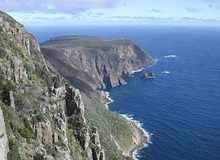
 Tasman Island (right) / Tasman Head / Tasman Peninsula Tasman Island (right) / Tasman Head / Tasman Peninsula
9.12.1798. Flinders. Named after its European discoverer, Abel Tasman, who sailed these waters in 1642. Six years earlier, D'Entrecasteaux had named the whole of the Tasman Peninsula 'Tasman Island', believing it to be an island. Furneaux had named it Cook's Peninsula. Baudin named Tasman Peninsula 'Baudin Island' and he called Tasman Head 'Cap Boreel'. It later became known as Hole In The Wall.
Munroe Bight
The Lanterns
The three rocky points are shaped like lanterns.
Hippolyte Rocks
11.5.1792. D'Entrecasteaux. Named after Hippolyte Deslacs, crew member, Recherche, who first sighted them.
Fortescue Bay
Named Dolomieu Bay by Baudin, 17.2.1802, after Deodat Guy Silvain Tancrede Gratet de Dolomieu (1750-1801), French mineralogist.
Thumb Point
 Cape Hauy (right) Cape Hauy (right)
17.2.1802. Peron. Named after René Just Haüy (1743-1822). French mineralogist, born at St. Just, in the department of Oise, educated at the colleges of Navarre and Lemoine, became a teacher at the latter and turned to natural history. He founded the science of crystallography.
O'Hara Bluff
Waterfall Bay
Hayes. Descriptive, as a number of waterfalls flow down its sheer cliffs into the ocean. Named Monge Bay by Baudin, 17.2.1802, after Gaspar Comte de Peluse Monge (1746-1818), French mathematician.
Forestier Peninsula
17.2.1802, Baudin. Named after Henry Verdean Forestier (1755-1806), French Minister for the Navy and administration.
Cape Surville
17.2.1802, Baudin. Named after Louis Charles de Hautefort, Marquis de Surville (1658-1721), French Admiral.
High Yellow Bluff
Descriptive.
Humper Bluff
Cape Frederick Hendrick
6.12.1642. Tasman. Named after Dutch Prince Regent Frederick Henrijk.
North Bay
Its locality in relation to the peninsula.
Cape Paul Lamanon
Possibly named by Marion Du Fresne after Chevalier Paul Lamanon, a naturalist and philosopher. Lamanon would later sail from Brest, in August, 1785, with French explorer la Perouse in the frigates Boussole and Astrolabe. Part of Bruni D'Entrecasteaux's mission in sailing the shores of Australia in 1792 was to find out what had happened to la Perouse who had disappeared without trace after leaving Botany Bay in 1788.
Blackman Bay
1793. Hayes. Tasman named it Frederick Henry Bay, 6.12.1642, after Dutch Prince Frederick Henrijk whose flad he planted on its shores. In 1773 when he visited the area, Furneaux mistook Blackman Bay for Frederick Henry Bay. Furneaux's charts were used to prepare the Admiralty charts of today, which is why the name still applies to the wrong bay. It was at Blackman Bay on 3rd December 1642 that Tasman's ship's carpenter, Peter Jacobsen, volunteered to swim ashore with a pole on which was the Prince's flag, which he planted on the shore of the bay. In doing so, Tasman had taken possession of Van Diemen's Land for the Dutch.
Marion Bay
17.2.1802, Freycinet. Named after Capt. Marion Du Fresne, French navigator and member of Baudin's expedition.
Visscher Island
12.1642. Tasman. Tasman may have named this island after his pilot-major, Frans Jacobszoon Visscher. According to Tasman's journal entry of 5th April 1643, Tasman named an island off New Guinea with the same name because "inshore of this island we saw some prows lying, which we supposed to be engaged in fishing, or which reason we have to this island given the name of Visschers island". Visscher is Dutch for 'fisher', ie. one who catches fish. Either suggestion for the naming of the Tasmanian Visscher Island is possible.
Cape Bernier
19.2.1802, Baudin. Named after Pierre Francois Bernier, astronomer, Naturaliste.
Mercury Passage
8.7.1789. Captain John Henry Cox, in the brig Mercury (aka Gustaf III) anchored in the strait between Maria Island and the mainland, naming it after his vessel. Cox was leading a nominally Swedish expedition sent to explore the north west coast of America.
Cockle Bay
Point Des Galets
19.2.1802, Baudin. Descriptive. Galet is the French word for 'pebbles'.
Lachlan Isld
Recalls either Gov. Lachlan Macquarie or his son (of the same name).
Johnson Pt
Stapleton Pt
Quarry Pt
A quarry was once worked here.
Prosser Bay
Pt Horne
Okehampton Bay
Lords Bluff
 Maria Isld (right) Maria Isld (right)
4.12.1642. Tasman. Named Maria's Eylandt by Tasman, after Maria Van Aelst, the wife of the the Governor-General of Batavia, Anthony Van Diemen. He married her on 17th January 1630 while in the East Indies. Maria was the widow of Bartholomeus Kunst. For many years it was asserted that Tasman had fallen in love with a daughter of Antonio Van Diemen, after whom he named the island, but Van Diemen had no daughters.
Cape Peron
19.2.1802, Baudin. Named after Francois Peron, expedition scientist, Naturaliste.
Cape Maurouard
19.2.1802, Baudin. Named after Jean Marie Maurouard, Assistant helmsman, Geographe, who headed an expedition around south Maria Island on 19th February.
Riedle Bay
4.2.1802, Baudin. Named after Anselme Riedle, head gardener at Kupang, Timor. Riedle was also the expedition's gardener. He died on Timor on 21st October 1802 during the latter part of the expedition.
Cape Mistaken
Originally amed Mauge Point by Baudin, 4.2.1802, after Rene Mauge, zoologist, who later died and was buried on Maria Island (see Pt Mauge below).
Cape Des Tombeaux
21.2.1802, Baudin. The word 'tombeau' is French for tombstone. It was here that Peron discovered an Aboriginal burial ground on 19th February.
Beaching Bay
21.2.1802, Baudin.Possibly because Baudin's crew went ashore here.
Cape Boullanger
21.2.1802, Baudin. Named after Charles Pierre Boullanger, midshipman, Geographe, who led an expedition around north Maria Island on 19th February.
Isle Du Nord
28.2.1802, Baudin. Means Northern Island.
Booming Bay
Named Port Montbazin by Baudin, 22.2.1802, Baudin, after the French town where Baudin grew up.
Pt Mauge
21.2.1802, Baudin. For Baudin's friend, Rene Mauge, a zoologist with the expedition who died here; on 21st February Mauge was buried on Maria Island.
Pt Lesueur
28.2.1802. Baudin. Named after Charles Alexander Lesueur, natural history artist, Géographe. Lesueur started out as an assistant gunner but became one of the artists when three artists left the expedition at Mauritius. He seems to have continued Francois Peron's work by describing some marine fish species (together with Peron) after Peron's death in 1810. Lesueur went on to become the first director of the Museum of Natural History at Le Havre in 1846. The Lesueur collection (Collection Lesueur) of art treasures is housed at the museum.
Shoal Bay
July 1789, Captain John Cox. Descriptive. Cox anchored at Shoal Bay, Maria Island, and made contact with the local Aborigines. From Maria Island, Captain Cox sailed into the Pacific.
Cape Bougainville
22.2.1802, Baudin. Named after Yves Phillippe Boughainville, midshipman, Geographe.
Grindstone Bay
Cape Bailly
28.2.1802, Baudin. Named after Joseph Charles Bailly, mineralogist, Naturaliste.
Mayfield Bay
Buxton Pt
Great Oyster Bay
July 1789, Captain John Cox. Plentiful in oysters. Cox anchored at Shoal Bay, Maria Island, to the south and made contact with the local Aborigines.
 Freycinet Peninsula (right) Freycinet Peninsula (right)
28.2.1802, Baudin. Named after 2nd Lieut. Louis Claude De Saules De Freycinet, Naturaliste. Previously named Van Der Lijn's Islandt by Abel Tasman, Dec 1642, after Cornelis Van Der Lijn, a member of the Dutch East India Company's Council of India. Van Der Lijn (1608-1679) was governor-general of Dutch East Indies from 1646 until 1650 and mayor of Alkmaar 1668-1678. In 1637 or 1639 (about this differ the sources), he had become a Councellor of the Duth East Indies Company. A year later he became president of the ship's court. In 1641, he became director-general of the Council of Dutch East Indies. During the years of Van Der Lijn's governorship, corruption within the company increased. The administrators in the Netherlands dismissed him on 7th October 1650, Carel Reyniersz was appointed as its successor. It was customary for a man of his standing to make his homecoming as a commander of the fleet. He was denied this honour after the free citizens of Batavia wrote a letter of protest to the Company which accused Van Der Lijn of corrupt financial dealings with the Chinese.
Wineglass Bay (right)
17.3.1773. Furneaux. Its shape.
Moulting Lagoon
Coles Bay
In the 1830s, Named after Silas Cole, a farm manager from Cranbrook, north of Swansea, who built a hut at the north-eastern end of Coles Bay in the vicinity of the present powered caravan sites in the Park. Cole burned shells from the enormous Aboriginal middens along Richardsons Beach to make lime, which was shipped to Swansea for use in mortar.
Promise Bay
![]() Schouten Isld / Schouten Passage Schouten Isld / Schouten Passage
Dec 1642. Tasman. Named after Justus Schouten, councillor of Dutch East India Company.
Taillefer Rocks
28.2.1802, Baudin. Recalls Hubert Jules Taillefer, the second doctor on the corvette Le Géographe.
Cape Sonnerat
28.2.1802, Baudin. Named after Pierre Sonnert (1748-1814), a French naturalist and explorer.
Cape Baudin
28.2.1802, Baudin. Named after expedition leader, Nicolas Baudin.
Cape Faure
28.2.1802, Baudin. Named after François Félix Faure (1841-1899), President of France from 1895 to his death in 1899.
Cape Forestier
21.2.1802, Baudin. Named after Henry Verdean Forestier (1755-1806), French Minister for the Navy and administration.
Thourin Bay
28.5.1802. Baudin. Possibly named after Louis Thourin, winner of the Legion of Honour, 1812.
Sleepy Bay
Cape Tourville
28.2.1802, Baudin. Named after Ann Hilarion de Contentin, Comte de Tourville (1642-1701), French admiral.
Bluestone Bay
Half Moon Bay
Its shape.
The Friendly Beaches
Isaacs Point
Butlers Point
Courland Bay
Recalls one of the historical and cultural regions of Latvia. The regions of Semigallia and Selonia are sometimes considered as part of Courland.
Cape Lodi
28.2.1802, Baudin. Recalls the place where Napoleon defeated the Austrians on 10th May 1796.
Cape Bicheno
Named Cape Degerando by Baudin, 22.2.1802, after Baron Marie Joseph De Gerando (1772-1842), French philosopher. Degerando was member of the committee which organised Baudin's expedition. Named after James Ebenezer Bicheno who was born in 1876, the son of a Baptist minister, at Newberry, County of Berkshire, England. In 1843 he was sent out by the Home Government to take up the position of Colonial Secretary of Van Diemen’s Land. Bicheno was a cultured man, Fellow of the Royal Society, of the Linnacan Society, and of the Geological Society of England. He was a genial, portly figure, fond of good living and good company, with a taste for music and the arts, he was widely popular.
Waubs Harbour
The name “Waubs” is an abbreviation of “Waubedebar”, a female aborigine whose grave is located at the back of the Lions Park, near the Silver Sands Hotel. The headstone reads “Here lies - Waubedebar a female aborigine of Van Diemen’s land, died June 1832, aged 40 years.” It seems that she was a sealer’s woman and that she died in a boat off the coast whilst travelling towards the Furneaux Group and her body was brought ashore and buried. John Allen, an early settler, in his note book, dated 24th June 1840, mentions “Waubs Harbour”. Sufficient was thought of her memory for the local settlers in 1855 to contribute funds to erect a headstone.
MacLean Bay
Long Pt
Piccaninny Pt
Named Cape Sonnerat by Nicolas Baudin.
St Patricks Head
17.3.1773. Furneaux. Discovered on St Patrick's Day.
Diana Basin
Henderson Lagoon
St Helens Pt / St Helens Isld
17.3.1773. Furneaux. Believed to be taken from St Helen's, an uninhabited island in the Isles of Scilly. These islands, which form an archipelago off the south-westernmost tip of the United Kingdom, are near Furneauz's birthplace, Swilly.
Georges Bay
Recalls George Augustus Robinson, who, in the 1830s on a 'friendly mission', persuaded the few remaining aborigines in the region to abandon their east coast heritage and follow him, ultimately to their demise.
Grant Pt
Named after James Grant, explorer
Binalong Bay
Aboriginal name for the area.
Skeleton Bay
Bay of Fires
18.3.1773. Furneaux. Many fires seen along this shore.
Ansons Bay
5.3.1788. Ball. Named after George Anson (1697-1762). British admiral, entered the navy in February 1712 and became lieutenant in 1716, commander in 1722 and post-captain in 1724. In 1737, he was appointed to the Centurion which, as flagship of a fleet of six ships, was sent out ill-equipped to attack the Spanish possessions in South America. After losing 5 ships by successive disasters, he circumnavigated the world in the course of eight years, capturing underway at Cape Espiritu Santo the Nuestra Señora de Covadonga. By the world at large, he is known as the commander of this voyage. In 1745, he was invited to join the Admiralty with the rank of rear-admiral of the white. In 1751, he became first Lord of the Admiralty.
Eddystone Point
18.3.1773. Furneaux. Resembled a lighthouse, which reminded Furneaux of eddystone Lighthouse in England. Named Fleurieu Pt by Baudin, 28.2.1802, after Charles Claret de Fleurieu (1689-1755), French philosopher and publisher.
Cape Naturaliste
28.2.1802, Baudin. Named after the expedition corvette, Naturaliste.
Mussel Roe Bay
Swan Isld
Banks Strait
Named after botanist Sir Joseph Banks.
Clarke Isld
Moriarty Pt / Moriarty Bay
Lookout Heads
9.3.1773. Furneaux. Used as a lookout.
Admiralty Channel
9.3.1773. Furneaux. Named after The British Admiralty, Furneaux's employer.
Cape Barren Island
9.3.1773. Furneaux. The island upon which Cape Barren was located.
Harley Pt
Cape Barren
9.3.1773. Furneaux. It appearance.
Cone Pt
9.3.1773. Furneaux. It appearance.
Passage Isld
9.3.1773. Furneaux. its location in a passage.
Preservation Isld
Forsythe Isld
Anderson Islds
Vansittart Isld
8.1.1799. Flinders. Named after Nicholas Vansittart, 1st Baron Bexley (1766-1851). British politician. He entered Parliament in 1796, was joint secretary of the treasury (1801-4, 1806-7) and briefly secretary for Ireland (1805), and in 1812 he became chancellor of the exchequer under the 2d earl of Liverpool. He held office for 11 years, dealing with the problems of economic adjustment that followed the end of the Napoleonic Wars. A loyal follower of Viscount Sidmouth, he resigned (1823) not long after Sidmouth. He was raised to the peerage in 1823 and remained in the cabinet as chancellor of the duchy of Lancaster until 1828.
Badger Isld
Chappell Isld
8.1.1799. Flinders. Named after Flinders' then-bride to be, Anne Chappelle.
Franklin Sound
Named after Sir John Franklin (1786-1847, Lieut. Governor of Tasmania. Midshipman on Investigator, English Rear-Admiral and explorer, was born at Spilsby, Lincolnshire, in a line of free-holders or "franklins" from whom they had derived their surname long before. As 5th and youngest son of nine children, he was destined for the church. However, he desired at an early age to be a sailor and overcame his father's resistance. At the age of 15, he took part in the battle of Copenhagen on board the Polyphemus. Two months later, he joined the Investigator and became Flinders' most adept student. After the end of the war with France, he turned to science and exploration on land and at sea. Between 1836 and the end of 1843, he was Lieutenant-Governor of Tasmania. His final task was the North-West Passage to the Pacific. The expedition embarked on Erebus and Terror on 19.05.1845 with 129 officers and men. It disappeared soon afterwards in the arctic waters and the search for it became one of the most taxing tasks of arctic exploration during the Ninteenth Century.
Furneaux Group
9.3.1773. Furneaux. Its discoverer and expedition leader, Tobias Furneaux.
 Flinders Isld Flinders Isld
8.1.1799. Flinders. Named after Samuel Flinders, 2nd Lieut., Investigator. He was Matthew Flinders' younger brother.
Rum Island (right)
Lacota Isld
Trousers Pt
Kangaroo Isld
Long Pt
9.3.1773. Furneaux. Its shape.
Arthur Bay
Named after Col. George Arthur, Lieut. Governor of Tasmania, 1824-36.
Hummock Isld
9.3.1773. Furneaux. Its shape.
Settlement Pt
Marshall Bay
South Pascoe Isld / Middle Pascoe Isld / North Pascoe Island
Cape Frankland
Recalls George Frankland (1800–38), who was the Surveyor General in Van Diemen's Land, 1826-38.
Warrigo Rock
Pyramid Rock
Its shape.
Wakitipu Rock
Craggy Isld / Craggy Rock
Descriptive.
Beagle Rock
Nov.1838. Wickham. expedition vessel, Beagle.
Wright Rock
Endeavour Reef
Possibly named after Cook's vessel for his second voyage of discovery, HMS Endeavour. Captain Cook and William Bligh visited the area in March 1776 on James Cook's third and final voyage of discovery in the Resolution and Discovery.
Sentinel Isld
Killiecrankie Bay
Has been recorded as being of Aboriginal origin, however this appears unlikely as it has the identical spelling of the Gaelic word for “aspen wood”. Scotland's Killiecrankie is a very narrow and steeply sided mountain pass between Blair Atholl and Pitlochry, in Perthshire. The bay takes its name from a nearby mountain that has that name. 'Killiecrankie' and 'Ben Nevis' are to be found on an 1831 map of Flinders Island, by surveyor George Woodward.
Bligh Pt
Captain William Bligh who visited the area in March 1776 on James Cook's third and final voyage of discovery in the Resolution and Discovery.
North Pt
Sister Islands (East and West)
19.3.1773. Furneaux. Two similar islands.
Babel Isld
9.12.1798. Flinders. the noise of many birds heard here.
Cat Isld
Cameron inlet
Hogan Group / Hogan Isld
8.2.1798. Flinders.
Cutter Rock
8.2.1798. Flinders.
Crocodile Rock
8.2.1798. Flinders. Its shape.
Curtis Group
11.12.1800. Grant. Named after Sir Roger Curtis. The islands resembled Lion's Mount at the Cape of Good Hope, where Sir Roger Curtis was commander.
Moncur Island
11.12.1800. Grant. Named after Capt. Moncur RN, an associate of Grant.
Kent Group
8.2.1798. Flinders. Named after Capt. William Kent, Master of HMS Supply.
Judgement Rock / Seat
8.2.1798. Flinders. A rock which looked like an elevated seat.
Cone Pt
11.2.1798. Flinders. Shaped like a rhinoseros horn.
Hamilton Road
11.2.1798. Flinders. Named after Capt, Hamilton whose ship, Sydney Cove, was lost there.
Armstrong Channel
16.2.1798. Flinders. Named after Capt Armstrong, HMS supply, who saved the cargo of the Sydney Cove.
Pt Wombat
16.2.1798. Flinders. Wombats seen there.
Battery Isld
16.2.1798. Flinders. Four projections resembled gun mountings.
Clark Isld
16.2.1798. Flinders. Named after John Clark, of wrecked ship, Sydney Cove.
Kent Bay
20.2.1798. Flinders. Named after William Kent, master of HMS Supply.
Passage Pt / Passage Isle
20.2.1798. Flinders. A passage located between Cape Barren Island and Clark Island.
Edith Isld
Dover Isld
Deal Isle
North East Isle
11.2.1798. Flinders. Its proximity to the rest of the islands in the group.
South West Isle
11.2.1798. Flinders. Its proximity to the rest of the islands in the group.
|