|
![]()
![]()
![]()
Cairns City Centre
![]()
The Big Marlin, Cairns
![]()
Marlin Wharf
![]()
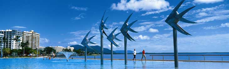
Cairns Public Lagoon

Cairns
![]()
Green Island, Great Barrier Reef
![]()
Ellis Beach, Cape Tribulation
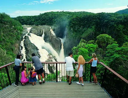
Barron Falls in the wet season
![]()
Kuranda Scenic Railway
|
Cairns is a popular travel destination for foreign tourists because of its tropical climate and proximity to many attractions. The Great Barrier Reef can be reached in less than an hour by boat. The Daintree National Park and Cape Tribulation, about 130 kilometres (80 miles) north of Cairns, are popular areas for experiencing a tropical rainforest. It is also a starting point for people wanting to explore Cooktown, Cape York Peninsula, and the Atherton Tableland.
Where is it?: Queensland: North. Cairns is located 1,678 km north west of Brisbane via Bruce Highway.
Events:
- May: Port Douglas Carnival
- July: Cairns Show
- August: Cairns Festival
- August: Atherton Maize Festival
- September: Festival Cairns
Surrounding area:
The Great Barrier Reef can be reached in less than an hour by boat. Green Island is the most popular destination on the reef. It has a world class resort.
Daintree National Park and Cape Tribulation (130km north) are popular areas for experiencing a tropical rainforest. North of Daintree National Park and Cape Tribulation is Cooktown, the starting point for people wanting to explore Cape York Peninsula.
Les than an hours drive from Cairns, The Atherton Tablelands is an area of world heritage rainforests, waterfalls, national parks, crater lakes and volcanic formations, set a backdrop of rolling green hills. Its numerous villages cater providing services such as accommodation, dining and shopping facilities for locally grown produce like wines and coffee.
Travel on one of Australia's finest tourist railways to the picturesque mountain retreat of Kuranda, the world famous village in the rainforest.
A pleasant day's drive noth from Cairns takes in Mossman Gorge and the the resort town of Port Douglas. Along the way, you can stop off to see crocodiles in their natural environment at Hartley's Crocodile adventures.
Surrounded by thick, lush rainforest, the Babinda Boulders (65km south) is a popular swimming hole and tourist attraction. It is a classic example of the fast flowing tropical creeks in the area that are perfect for afternoon dips in the cool water to combat the tropical heat. More >>
About Cairns
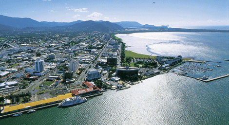
Cairns is located on the east coast of Cape York Peninsula on a coastal strip between the Coral Sea and the Great Dividing Range. The northern part of the city is located on Trinity Bay and the city centre is located on Trinity Inlet. Some of the city's suburbs are located on fertile flood plains. The Mulgrave River and Barron River flow within the city's boundary but not through the city itself. The city centre's foreshore is located on a mud flat. The highest mountain in Queensland, Mount Bartle Frere, is located within the city's boundaries.
Though the sugar industry is still a major income producer for Cairns, tourism is number one these days and this is reflected in the way the city has opened its doors and laid out the welcome mat for visitors from all over the world. The city is very visitor friendly - when walking on the Esplanade by the swimming lagoon on the ocean side, or the many cafes, restaurants and shops on the city side, one feels safe and comfortable, even late at night when all these visitor facilities are still open.
The city has used its natural surroundings to its advantage, with the construction of several small theme parks for tourists. Among them are Rainforestation Nature Park, Tjapukai Aboriginal Cultural Park, and Kuranda Skyrail Rainforest Cableway, which extends for 7.5 km over World Heritage rainforest. Cairns is also a major international destination for scuba diving due to its close proximity to the Great Barrier Reef. Other recreational activities popular with tourists include whitewater rafting and snorkelling.
![]()
Related Pages: Atherton Tableland | Far North Queensland
Climate: Cairns experiences a warm tropical climate. It experiences a dry season between April and November and a wet season with tropical monsoons between November and March. Mean rainfall of Cairns is 2002.9 mm.[5] The township of Babinda at the southern end of the city is one of Australia's wettest towns, recording an annual rainfall of over 4200 mm. It has hot humid summers and milder temperatures in winter. The temperature varies from a mean temperature of 25.7 °C in July to 31.4 °C in January. Monsoonal activity during the wet season occasionally causes major flooding of the Barron and Mulgrave Rivers, cutting off road and rail access to the city.
Like most of North and Far North Queensland, Cairns is prone to Tropical Cyclones, usually forming between November and May. Wind gusts of up to 300 km/h have been recorded around the Cairns region, with wind gusts up to 180km/h reported in the City. It is estimated that about one in four houses in Cairns and surrounding areas were affected by Cyclone Larry.
How to get there: Cairns is reached by road via the Bruce Highway runs for 1700 km from Brisbane and terminates in Cairns on the corner of Mulgrave Roads and Sheridan Streets in the CBD. At this point, the Captain Cook Highway (also referred to as the Cook Highway), between Cairns and Port Douglas approximately 70 km to the northwest, commences.
Cairns is served by long distance coaches to Brisbane, and regional cities to the south. Coaches also operate west to Mount Isa via Townsville and the Northern Territory. Desert Venturer Coaches operate twice weekly to Alice Springs and Darwin (weekly service in wet season).
Cairns is the terminus for Queensland's North Coast railway line, which follows the eastern seaboard from Brisbane. Services are operated by Queensland Rail (QR) and include the high speed tilt train.
Cairns International Airport is located 7km north of Cairns City between the CBD and the Northern Beaches. It is Australia's sixth busiest in terms of international and domestic passenger movements. The Airport has a domestic terminal, a separate international terminal, and a general aviation area. The airport handles international flights, and daily flights to major Australian cities, tourist destinations, and regional destinations throughout North Queensland. It is an important base for general aviation serving the Cape York Peninsula and Gulf of Carpentaria Communities. The Cairns airport is also a base for the Royal Flying Doctor Service.
Getting around: A public transport network is operated throughout the city by Sunbus. A transit mall is located in the CBD through which all services operate. Services include most parts of the city, from Palm Cove on the Northern Beaches to Gordonvale in the south, all travelling via the CBD. Bus services operated by Whitecar Coaches run to Kuranda and to the Atherton Tableland. A smaller minibus service, Jon's Kuranda Bus runs between Cairns and Kuranda.
|