| SHOW CAVES
State and Territory index
|
|
QUEENSLAND
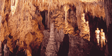
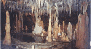
Crystal Caves (Atherton Tablelands, North Qld)
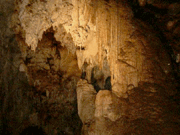
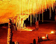
 The Crystal Caves on the Atherton Tablelands are one of the largest private mineralogical museums in Australia. A labyrinth of caves can be explored on two levels over 250m to discover spectacular and colourful natural crystals, ancient fossils, and rare delicate minerals. Entering at the 'Calcite Cavern' where Crystals glitter to form a star like galaxy, there are over 600 crystals and fossils to see. Hundreds of little spotlights gleam in the darkness and show you the way, there is an 80 million year old amazing water agate, and an impressive 525 kg boulder of Rose Quartz. The walk-in fluorescent grotto the 'Magic Temple' is Australia's largest and most spectacular collection of fluorescent minerals. The fairytale chamber contains the largest selenite crystals in the world from 'The Cave of Swords' in Mexico. Website The Crystal Caves on the Atherton Tablelands are one of the largest private mineralogical museums in Australia. A labyrinth of caves can be explored on two levels over 250m to discover spectacular and colourful natural crystals, ancient fossils, and rare delicate minerals. Entering at the 'Calcite Cavern' where Crystals glitter to form a star like galaxy, there are over 600 crystals and fossils to see. Hundreds of little spotlights gleam in the darkness and show you the way, there is an 80 million year old amazing water agate, and an impressive 525 kg boulder of Rose Quartz. The walk-in fluorescent grotto the 'Magic Temple' is Australia's largest and most spectacular collection of fluorescent minerals. The fairytale chamber contains the largest selenite crystals in the world from 'The Cave of Swords' in Mexico. Website
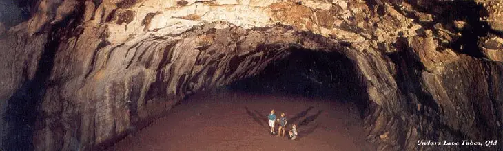
Undara Lava Tubes (North Qld)
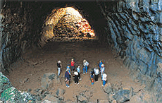 The Undara Lava Tubes (Undara Volcanic National Park) near the small town of Mount Surprise 275 km south-west of Cairns, is one of Australia's great geological wonders. They are the largest, longest and most accessible lava tubes on earth. Undara volcano erupted 190,000 years ago and spewed 23 cubic kilometres of molten lava onto the surrounding country. Streams of sulphurous lava flowed over the land, spilling out like boiling treacle into various creek beds and other depressions. The surface soon cooled and crusted but the molten lava inside continued to flow, leaving behind the huge hollow pipes ... the unique lava tubes. The Undara Lava Tubes (Undara Volcanic National Park) near the small town of Mount Surprise 275 km south-west of Cairns, is one of Australia's great geological wonders. They are the largest, longest and most accessible lava tubes on earth. Undara volcano erupted 190,000 years ago and spewed 23 cubic kilometres of molten lava onto the surrounding country. Streams of sulphurous lava flowed over the land, spilling out like boiling treacle into various creek beds and other depressions. The surface soon cooled and crusted but the molten lava inside continued to flow, leaving behind the huge hollow pipes ... the unique lava tubes.
More ...
Camooweal Caves (Far western Qld)
A large cave system that is growing larger each year with the soluble dolomite being continually eroded by the flooding during the wet season. The largest cave is the Great Nowranie: 290 metres long and 70 metres high it is also one of the easiest to access. Located in the Camooweal Caves National Park.
More ...
Chillagoe Caves (North Qld)
 In an area characterised by volcanic activity it is surprising to find limestone caves, however the limestone in the area is the result of an unusual uplift of sediments (that include coral) which were deposited in the ocean off the edge of the Australian continent about 400 million years ago. As the sea level rose, the continental shelf moved east and then, about 360 million years ago the sediments were compressed and uplifted. Over 600 caves have been documented in the Chillagoe region, with the largest system claimed to contain over 6.5 km of passage. Every cave is different and names such as 'The Cathedral Cave, or 'The Piano Cave', often give clues to what may be found within. In an area characterised by volcanic activity it is surprising to find limestone caves, however the limestone in the area is the result of an unusual uplift of sediments (that include coral) which were deposited in the ocean off the edge of the Australian continent about 400 million years ago. As the sea level rose, the continental shelf moved east and then, about 360 million years ago the sediments were compressed and uplifted. Over 600 caves have been documented in the Chillagoe region, with the largest system claimed to contain over 6.5 km of passage. Every cave is different and names such as 'The Cathedral Cave, or 'The Piano Cave', often give clues to what may be found within.
More ...
WESTERN AUSTRALIA
Nullarbor Plain (Outback WA)
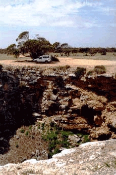 There are many caves and sinkholes across the Nullarbor, some with several kilometres of passages, and some approved for public investigation. The Murrawijinie caves north of Nullarbor, Koonalda and Bunaby Blowhole can be visited, and others are only accessible in the company of a National Parks and Wildlife officer. There are many caves and sinkholes across the Nullarbor, some with several kilometres of passages, and some approved for public investigation. The Murrawijinie caves north of Nullarbor, Koonalda and Bunaby Blowhole can be visited, and others are only accessible in the company of a National Parks and Wildlife officer.
In recent years Cocklebiddy has gained an international reputation as a site for one of the world's largest cave systems. Ten kilometres to the north west of Cocklebiddy Roadhouse lies Cocklebiddy cave. In 1983 a French caving expedition created caving history by exploring Cocklebiddy Cave to an unprecedented distance of 6.4 kilometres. The Cocklebiddy cave system is unique in that it extensively penetrates an aquifer that lies 90 metres below the Nullarbor Plain. Within Cocklebiddy cave are a number of vast limestone caverns, rockfalls and saline subterranean lakes that extend for several hundred metres. More ...
Yallingup Caves
Yallingup Cave, near Yallingup township and 8km west from Dunsborough, is also known Ngilgi Cave. Ngilgi is a local Aboriginal name given to the cave; a legend recounts the Dreamtime origins of the cave in terms of a vicious fight between a bad spirits that lived inside the cave and a good spirit Ngilgi who lived in the ocean. Whilst searching for stray horses, Edward Dawson discovered the cave in 1899. He began taking tourists through the cave in 1900. The tours were so popular that Caves House Hotel was built to accommodate the many visitors that would travel by horse and cart from Busselton. Today, the cave is open every day and tours are self-paced with guides available to answer questions. Visitors can view the First Chamber, the Main Chamber and the Amphitheatre. The cave is noted for its impressive Mother-of-Pearl and Oriental Shawls and the red and orange coloured Arabs Tent. More ...
 Margaret River Caves Margaret River Caves
A system of limestone caves are located in the Margaret River area, starting at Calgardup Brook and finishing at Ellensbrook. Mammoth Cave, 21km south or fifteen minutes drive of the Margaret River township, offers an ultra modern self-guided tour through the massive caverns and tunnels. Discovered by Tim Connelly around 1900, some of the most valuable fossils in the southwest were found here. The remains of a Tasmanian devil, a Tasmanian tiger and a giant kangaroo have been found inside Mammoth Cave. These species have been extinct in this part of Australia for centuries. A total of over 10,000bones were found inside the cave, some fossils over 35.000years old. Its massive cavern, unusual stone formations, newly built boardwalks and CD-ROM headsets will make your experience a safe and educational one.
Just 2km south of Mammoth Cave lies Lake Cave, the most delicate and pretty of the entire southwest caves. With its specially designed coloured feature lighting, impressive natural entrance, and boardwalks, Lake Cave is a must-see for the Margaret River Area. Its most outstanding feature is the unique, suspended table formation that was originally two massive columns joined by a sheet of calcite on the cave floor. Over time, the stream has washed away the bottom of the sheet, leaving a thin table suspended a short distance above the water. It looks spectacular reflecting in the dark, icy waters of the lake in the main cavern. More ...
Augusta Caves
 Jewel Cave, 37km south of Margaret River Township along Caves Road, contains a number of interesting crystalline formations including the Waterfall, the Organ Pipe and the worlds largest straw stalactite in a tourist cave. The mangled forms of helictites- twisted, contorted stalactites that appear to defy gravity by growing sideways and upwards will amaze you and when the lights go out you get a real feel for the isolation of this stupendous underground landscape. More ... Jewel Cave, 37km south of Margaret River Township along Caves Road, contains a number of interesting crystalline formations including the Waterfall, the Organ Pipe and the worlds largest straw stalactite in a tourist cave. The mangled forms of helictites- twisted, contorted stalactites that appear to defy gravity by growing sideways and upwards will amaze you and when the lights go out you get a real feel for the isolation of this stupendous underground landscape. More ...
Stockyard Gully Caves (Central Agricultural WA)
 These caves, located near Eneabba, were created by an underground river system. Two of them are easily accessible - Stockyard Tunnel is 300 m long and requires no gear except for the torch; Stockyard Cave is 800 m long, but slime and mud often coats most of the boulders, making them extremely slippery. Aiyennu Cave boasts a sheer drop of 40 meters but is not open to the public. Unfortunately, none of these places are well developed for tourism; they can be accessed by four-wheel drive vehicle only. Website These caves, located near Eneabba, were created by an underground river system. Two of them are easily accessible - Stockyard Tunnel is 300 m long and requires no gear except for the torch; Stockyard Cave is 800 m long, but slime and mud often coats most of the boulders, making them extremely slippery. Aiyennu Cave boasts a sheer drop of 40 meters but is not open to the public. Unfortunately, none of these places are well developed for tourism; they can be accessed by four-wheel drive vehicle only. Website
Yanchep Caves (near Perth, WA)
 A series of caves are contained mainly within the Yanchep National Park beyond the northern extremity of the Perth metropolitan area. There is currently only one tourist cave in the National Park, namely Crystal Cave, though there is talk of reinstating Yonderup Cave as a tourist cave. There are also many 'wild', mainly small caves. The area has possibly as many as 1000 caves and karst features some of which are waiting to be rediscovered such as The Catacombs. As the limestone here is only 10m above the water-table, there have been frequent collapses. More ... A series of caves are contained mainly within the Yanchep National Park beyond the northern extremity of the Perth metropolitan area. There is currently only one tourist cave in the National Park, namely Crystal Cave, though there is talk of reinstating Yonderup Cave as a tourist cave. There are also many 'wild', mainly small caves. The area has possibly as many as 1000 caves and karst features some of which are waiting to be rediscovered such as The Catacombs. As the limestone here is only 10m above the water-table, there have been frequent collapses. More ...
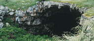
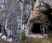
Tunnel Creek (Kimberleys WA)
 Tunnel Creek, situated 36km east of Windjana Gorge in Tunnel Creek National Park in the north of Western Australia, its takes its name from the 750 metre long tunnel carved by flowing water out of the limestone of the Napier Range, and is part of the 375 to 350 million-year-old Devonian Reef system. Western Australia's oldest cave system, it is famous as a hideout used late last century by an Aboriginal leader known as Jandamarra. He was killed outside its entrance in 1897. Tunnel creek is, as the name implies, a tunnel, cut through one section of the reef by a small creek, with a collapsed roof in the middle. To pass through it to the other side of Napier Range, you have to wade through long waterholes up your waist and at times up to your chest. More ... Tunnel Creek, situated 36km east of Windjana Gorge in Tunnel Creek National Park in the north of Western Australia, its takes its name from the 750 metre long tunnel carved by flowing water out of the limestone of the Napier Range, and is part of the 375 to 350 million-year-old Devonian Reef system. Western Australia's oldest cave system, it is famous as a hideout used late last century by an Aboriginal leader known as Jandamarra. He was killed outside its entrance in 1897. Tunnel creek is, as the name implies, a tunnel, cut through one section of the reef by a small creek, with a collapsed roof in the middle. To pass through it to the other side of Napier Range, you have to wade through long waterholes up your waist and at times up to your chest. More ...
VICTORIA
Buchan Caves (Gippsland Vic)
 Near the township of Buchan, lies a honeycomb of caves full of spectacular limestone formations. Buchan Caves were formed by underground rivers cutting through limestone rock. The formations are created by rain water seeping through cracks and dissolving some of the limestone. The Reserve was established to cater to the needs of the thousands of visitors who visit the caves each year. More ... Near the township of Buchan, lies a honeycomb of caves full of spectacular limestone formations. Buchan Caves were formed by underground rivers cutting through limestone rock. The formations are created by rain water seeping through cracks and dissolving some of the limestone. The Reserve was established to cater to the needs of the thousands of visitors who visit the caves each year. More ...
Mt. Buffalo Underground River Cave (High Country Vic)
The Cave is a granite boulder infill cave some 400 metres long with about 100 to 150 metres easily navigable (for a normal group, this can take up to 1 & 1/2 to 2 hours). During November to January there is often swift running water in the Cave and this adds to the Adventure. The expedition is always partly in water and you will get wet and cold, see clothing requirements in "you need".
There are glowworms in the cave and although sometimes elusive, they can often be seen from early January to the end of Summer. There are also cave dwelling spiders, cave crickets and other insects. In Early autumn there are unusual Fungi in the cave as well. The cave is located in the Mt. Buffalo National Park. More ...
Byaduk Caves (Western Vic)
 The caves are located in a lava flow stretching out 24km from Mount Napier to Mount Eccles in Victoria within the Mount Napier State Park and Mount Eccles National Park. The lava tubes contain wrinkles, stalactites and stalagmites, columns and ropy lava. Volcanic eruptions in this area began about 20,000 years ago and continued for the next 12,000 years. Only one cave of Byaduk Caves, Harman 1, is open to the public. Bent-wing Bats spend the winter in some of the caves hibernating. This caves are closed to visitors during the winter. Byaduk Caves are located 300km south-west of Melbourne, 45km south of Hamilton. More ... The caves are located in a lava flow stretching out 24km from Mount Napier to Mount Eccles in Victoria within the Mount Napier State Park and Mount Eccles National Park. The lava tubes contain wrinkles, stalactites and stalagmites, columns and ropy lava. Volcanic eruptions in this area began about 20,000 years ago and continued for the next 12,000 years. Only one cave of Byaduk Caves, Harman 1, is open to the public. Bent-wing Bats spend the winter in some of the caves hibernating. This caves are closed to visitors during the winter. Byaduk Caves are located 300km south-west of Melbourne, 45km south of Hamilton. More ...
Labertouche Caves (Gippsland Vic)
These are Granite Boulder Infill Caves (which are rarer than Limestone or Lava Tube Caves, but well represented as a cave type in Victoria). This type of cave is formed when a large mass of granite weathers in such a way as to form a huge boulder jumble that has linked gaps between the boulders forming tunnels and caverns that are in total darkness and which can be navigated by competent Cavers. The caves have active streams and also limited cave ecology such as Glowworms, Spiders and Fungi. The caves are overlaid with sediment. Labertouche Cave is near Drouin, Victoria. More ...
Princess Margaret Rose Caves (Western Vic)
 Of the many limestone caves in Lower Glenelg National Park, the main cave of the Princess Margaret Rose Caves is the most attractive and the only cave suitable for public use. It contains excellent examples of actively growing stalactites, stalagmites, helictites and other spectacular limestone formations. Most limestone caves are formed by water seeping down through cracks and faultlines in the limestone, dissolving the rock and creating fissures and tunnels. The formation of Princess Margaret Rose Caves, however, was assisted by water from the Glenelg River which worked its way along a faultline for 300m. This occurred above its present height. The water scalloped the walls of the cave and wore a reasonably level floor. Of the many limestone caves in Lower Glenelg National Park, the main cave of the Princess Margaret Rose Caves is the most attractive and the only cave suitable for public use. It contains excellent examples of actively growing stalactites, stalagmites, helictites and other spectacular limestone formations. Most limestone caves are formed by water seeping down through cracks and faultlines in the limestone, dissolving the rock and creating fissures and tunnels. The formation of Princess Margaret Rose Caves, however, was assisted by water from the Glenelg River which worked its way along a faultline for 300m. This occurred above its present height. The water scalloped the walls of the cave and wore a reasonably level floor.
Perhaps the most unusual formations in the cave are the helictites. Defying gravity, these long, thin formations grow in all different directions. Noone is certain how they form, but the are commonly accepted theory is that they begin on crystals and are shaped by surface tensions and air currents. Another mysterious formation in the Princess Margaret Rose Caves is the rarely seen cave coral. More ...
Britannia Creek Cave (Gippsland Vic)
Granite Boulder Infill Caves (see Labertouche Caves above) which are rarer than Limestone or Lava Tube Caves, but well represented as a cave type in Victoria. The caves has active streams and also limited cave ecology such as Glowworms, Spiders and Fungi. Britannia Creek cave is at Yarra Junction near Warburton. More ...
NORTHERN TERRITORY
Cutta Cutta Caves (Top End NT)
 The caves were formed millions of years ago and still growing today, these fascinating limestone rock formations are about 15 metres below the earth's surface. The landscape surrounding the caves is unique, featuring 2 interesting short walks in the area. Cutta Cutta and Tindal caves are home to a variety of wildlife, including the Brown Tree Snake and the rare Orange Horseshoe bat. The cave are located in the Cutta Cutta Caves Nature Park. Access is via the Stuart Highway 30 km south of Katherine. More ... The caves were formed millions of years ago and still growing today, these fascinating limestone rock formations are about 15 metres below the earth's surface. The landscape surrounding the caves is unique, featuring 2 interesting short walks in the area. Cutta Cutta and Tindal caves are home to a variety of wildlife, including the Brown Tree Snake and the rare Orange Horseshoe bat. The cave are located in the Cutta Cutta Caves Nature Park. Access is via the Stuart Highway 30 km south of Katherine. More ...
Gregory Karst (Top End NT)
Located about 45 kilometres south of Timber Creek, part of the Victoria River region and within the Gregory National Park. The karst is believed to extend some 20 kilometres north-south and up to one kilometre wide. With many outlying exposures that may still not have been explored and exposures along other rivers outside the Gregory National Park, the total length of known caves now exceed 150 kilometres. The Bullita Cave System, also known as 'Burkes Backyard' in 2001 was the longest cave in Australia at 81 kilometres, with the length being added to by up to ten kilometres each year. With limited development of the Park and the rugged remoteness of the karst, casual cave exploration is not encouraged, with permission required from the Northern Territory Conservation Commission. More ...
Lasseter's Cave (NT)
 Lasseter's Cave is situated on the Hull River. Its name recalls Lewis Harold Bell Lasseter, a gold prospector in the area who became stranded when his camels bolted in the heat of summer in January 1931 leaving him with no provisions. He actually sheltered in the tiny cave alongside the running waters of the Hull River for 25 days waiting for his relief party to find him but when they didn't come he set out to walk to the Olgas. He only carried 1.7L of water and made just 55 kilometres before dying. Lasseter's Cave is situated on the Hull River. Its name recalls Lewis Harold Bell Lasseter, a gold prospector in the area who became stranded when his camels bolted in the heat of summer in January 1931 leaving him with no provisions. He actually sheltered in the tiny cave alongside the running waters of the Hull River for 25 days waiting for his relief party to find him but when they didn't come he set out to walk to the Olgas. He only carried 1.7L of water and made just 55 kilometres before dying.
More ...
|
NEW SOUTH WALES
Jenolan Caves (Blue Mountains, NSW)
 Jenolan Caves are without question, Australia's most impressive limestone caves. Located near the Blue Mountains, the caves were discovered in 1838 by a convict bushranger. There are nine show caves open to the public with spectacular lighting, underground rivers and cave formations that will amaze you. Tour guides take visitors through the caves. Some caves are tougher than others. Jenolan Caves also offer adventure tours, picnic facilities and bush walking tracks. The drive to Jenolan Caves is also a pleasant experience. The natural welcoming of the Grand Arch is unforgettable. The acoustics of the Archway make any concert performed there a truly magical event. Website Jenolan Caves are without question, Australia's most impressive limestone caves. Located near the Blue Mountains, the caves were discovered in 1838 by a convict bushranger. There are nine show caves open to the public with spectacular lighting, underground rivers and cave formations that will amaze you. Tour guides take visitors through the caves. Some caves are tougher than others. Jenolan Caves also offer adventure tours, picnic facilities and bush walking tracks. The drive to Jenolan Caves is also a pleasant experience. The natural welcoming of the Grand Arch is unforgettable. The acoustics of the Archway make any concert performed there a truly magical event. Website
Wombeyan Caves (Southern Agricultural NSW)
 Hidden in the Southern Highlands of NSW is the natural marvel of Wombeyan Caves. The underground world of Wombeyan is easy to discover with the aid of an experienced guide. They are well lit with clear pathways to follow. Figtree cave is Wombeyan's magnificent self-guided cave. Wombeyan also offers the thrill of adventure caving in a wild cave, where crawling, climbing and squeezing. A less strenuous adventure involves stepping back in time to take a historical tour to explore by torchlight undisturbed passages in the footsteps of the explorers, seeing the magic of the cave as they did, more than a century ago. More ... Hidden in the Southern Highlands of NSW is the natural marvel of Wombeyan Caves. The underground world of Wombeyan is easy to discover with the aid of an experienced guide. They are well lit with clear pathways to follow. Figtree cave is Wombeyan's magnificent self-guided cave. Wombeyan also offers the thrill of adventure caving in a wild cave, where crawling, climbing and squeezing. A less strenuous adventure involves stepping back in time to take a historical tour to explore by torchlight undisturbed passages in the footsteps of the explorers, seeing the magic of the cave as they did, more than a century ago. More ...
Abercrombie Caves (Central Western NSW)
 One of the first recorded references to this cave system was in the 6th October 1821 edition of the Sydney Gazette, which mentioned "...a cave of considerable dimensions ... near Bathurst". Around this time local settlers and stockmen referred to a place known as the "Bridge" somewhere in the neighbourhood. The first European visitors to the caves appear to have been settlers and Bushrangers. The first recorded tourist party visited Abercrombie in 1834. However, the Caves were not officially discovered until 1842 by Surveyor WR Davidson. One of the first recorded references to this cave system was in the 6th October 1821 edition of the Sydney Gazette, which mentioned "...a cave of considerable dimensions ... near Bathurst". Around this time local settlers and stockmen referred to a place known as the "Bridge" somewhere in the neighbourhood. The first European visitors to the caves appear to have been settlers and Bushrangers. The first recorded tourist party visited Abercrombie in 1834. However, the Caves were not officially discovered until 1842 by Surveyor WR Davidson.
More ...
Borenore Caves (Central western NSW)
 Forbes Road, Orange. These natural wonders located just 17 kilometres from Orange are ideal for a morning adventure, a midday explore, afternoon bushwalk or a day relaxing in the sun. These un-developed caves do not have guides or tours. The management of Borenore Caves was transferred to the care of the Jenolan Caves Reserve Trust in December 1997. Since the transfer, efforts have been focused on introductory meetings with stakeholders and general maintenance programs which have been undertaken by the staff of Abercrombie Caves and volunteer workers. More ... Forbes Road, Orange. These natural wonders located just 17 kilometres from Orange are ideal for a morning adventure, a midday explore, afternoon bushwalk or a day relaxing in the sun. These un-developed caves do not have guides or tours. The management of Borenore Caves was transferred to the care of the Jenolan Caves Reserve Trust in December 1997. Since the transfer, efforts have been focused on introductory meetings with stakeholders and general maintenance programs which have been undertaken by the staff of Abercrombie Caves and volunteer workers. More ...
Wellington Caves (Central western NSW)
 Wellington Caves are thought to have been discovered in 1830 by a colonist, George Ranken, who accidentally fell into the entrance of one of the caves. In one cave, now known as the Bone Cave were found fossilised skeletons of many giant animals which roamed the Wellington valley millions of years ago. It is now reserved for the exclusive use of scientists from all parts of the world. Wellington Caves are thought to have been discovered in 1830 by a colonist, George Ranken, who accidentally fell into the entrance of one of the caves. In one cave, now known as the Bone Cave were found fossilised skeletons of many giant animals which roamed the Wellington valley millions of years ago. It is now reserved for the exclusive use of scientists from all parts of the world.
Today, the Cathedral Cave and the Gaden Cave are open for public inspection. The Cathedral Cave is a vast area where visitors are confronted by a truly gigantic stalagmite, regarded as one of the largest in the world. It rises to a height of about 15m and measures about 32m around the base. Illuminated by hidden lights, it has a majestic appearance and is popularly known as 'the Madonna'. The Gaden Cave is smaller but has unusual and exquisite formations.
Website | Wellington's giant fossils
Yarrangobilly Caves (Southern Agricultural NSW)
 Located in the Snowy Mountains, these caves are worth a visit if you are ever in the area as they are some of the most beautiful caves in Australia. There are caves which can be self -guided or there are guided cave inspections such as the beautiful Jersey Cave, the wheelchair accessible Jillabenan Cave, (one of the most highly decorated caves in eastern Australia) or the immense North Glory Cave. The area has a rich Aboriginal and European history. As well as cave inspections undertaken with experienced guides, there are a number of short walks and the popular thermal pool for swimming. Located in the Snowy Mountains, these caves are worth a visit if you are ever in the area as they are some of the most beautiful caves in Australia. There are caves which can be self -guided or there are guided cave inspections such as the beautiful Jersey Cave, the wheelchair accessible Jillabenan Cave, (one of the most highly decorated caves in eastern Australia) or the immense North Glory Cave. The area has a rich Aboriginal and European history. As well as cave inspections undertaken with experienced guides, there are a number of short walks and the popular thermal pool for swimming.
More ...
Yessabah Caves (Northern NSW)
 Yessabah Nature Reserve covers 10ha and is located 15 km west-south-west of Kempsey in the lower Macleay Valley on the mid north coast of NSW. Yessabah Nature Reserve was originally set aside in 1890 as a reservation for Public Recreation and the Preservation of Caves. It encompasses a substantial portion of Yessabah Hill, an outcrop of the Yessabah Limestone Belt. The limestone on the reserve has the highest concentration of caves in northern NSW, which are used for speleological and educational purposes. The Yessabah Caves are very important to the southernmost population of the little bent-wing bat in NSW and they provide the autumn-winter roosting site for a population of this species. Yessabah Nature Reserve covers 10ha and is located 15 km west-south-west of Kempsey in the lower Macleay Valley on the mid north coast of NSW. Yessabah Nature Reserve was originally set aside in 1890 as a reservation for Public Recreation and the Preservation of Caves. It encompasses a substantial portion of Yessabah Hill, an outcrop of the Yessabah Limestone Belt. The limestone on the reserve has the highest concentration of caves in northern NSW, which are used for speleological and educational purposes. The Yessabah Caves are very important to the southernmost population of the little bent-wing bat in NSW and they provide the autumn-winter roosting site for a population of this species.
More ...
Wee Jasper Caves (Southern Agricultural NSW)
 There are numerous limestone caves in the Wee Jasper valley, the best known being Carey's Cave, which is open for inspection. It penetrates roughly in a horizontal manner into the side of a hill so even people with mobility problems can appreciate the charms of the caves. The cave is well lit throughout by electric lights and the guides are well versed in both the folklore and science of the caves. Number one priority of the Carey's Cave guides is that you have a good time, irrespective of child, adult or non-English speaker. There are numerous limestone caves in the Wee Jasper valley, the best known being Carey's Cave, which is open for inspection. It penetrates roughly in a horizontal manner into the side of a hill so even people with mobility problems can appreciate the charms of the caves. The cave is well lit throughout by electric lights and the guides are well versed in both the folklore and science of the caves. Number one priority of the Carey's Cave guides is that you have a good time, irrespective of child, adult or non-English speaker.
The Dip Cave is located 4.5km out of Wee Jasper. Tackle is required for the cave is 10m of ladder and rope as safety line. Dogleg cave requires no rope work, however this cave can flash flood during heavy rain. Punchbowl-Signature caves require a 40m rope and ladder for the 24m pitch in to the Punchbowl Cave. Website
Nangwarry Caves (South Coast NSW)
These caves are to be found near the bank of the Shoalhaven River within 50 kilometres of Nowra. The caves are in Permian Sandstone (Nowra Sandstone, Shoalhaven Group) and are generally rift-like. They run approximately parallel to the cliff line and are no more than 15 m from it, in several places opening out onto the cliff face. It appears that large blocks have broken away from the cliff and have begun to move down the slope towards the river, but on examination of the relief of the two walls, it seems that generally there has been very little vertical movement, although horizontal movement averages about 1 m. The roof and any false floors were probably formed when smaller blocks were wedged into the rift.
More ...
SOUTH AUSTRALIA
Yourambulla Caves (Flinders Ranges, SA)
 The name Yourambulla is derived from the Adnyamathanha phrase "yura pilla", meaning two men, and is related to the two peaks to the east of the painting sites. In Adnyamathanha legend two men of different kinship, "arraru" and "mathari", camped where the two peaks now stand, to eat part of a man they were carrying. It is thought that the smaller peak is the "mathari" man and that the larger the "arraru" man. A number of Aboriginal paintings and etchings occur in this area, and are housed in rock shelters and the caves accessible by marked walking trails. The caves and paintings are located 11 km south of Hawker off the main Quorn road. More ... The name Yourambulla is derived from the Adnyamathanha phrase "yura pilla", meaning two men, and is related to the two peaks to the east of the painting sites. In Adnyamathanha legend two men of different kinship, "arraru" and "mathari", camped where the two peaks now stand, to eat part of a man they were carrying. It is thought that the smaller peak is the "mathari" man and that the larger the "arraru" man. A number of Aboriginal paintings and etchings occur in this area, and are housed in rock shelters and the caves accessible by marked walking trails. The caves and paintings are located 11 km south of Hawker off the main Quorn road. More ...
Kelly Hill Caves (Kangaroo Island, SA)
 The Kelly Hill Caves on Kangaroo Island were discovered by accident in 1881 when a horse named Kelly fell into one. The caves are a beautiful system of caverns and sinkholes that are lit using fibre-optic "white light" technology. This allows visitors to see the stunning natural colours. Guided tours run daily, but the more daring can take an adventure caving tour for a deeper look into this underground world of ornate calcite formations. The original entrance to the cave system is still in use today for adventure tours of the cave. More ... The Kelly Hill Caves on Kangaroo Island were discovered by accident in 1881 when a horse named Kelly fell into one. The caves are a beautiful system of caverns and sinkholes that are lit using fibre-optic "white light" technology. This allows visitors to see the stunning natural colours. Guided tours run daily, but the more daring can take an adventure caving tour for a deeper look into this underground world of ornate calcite formations. The original entrance to the cave system is still in use today for adventure tours of the cave. More ...
Koonalda Cave (Outback SA)
Koonalda is a limestone cave located in the Nullarbor Plain of South Australia near the Great Australian Bight. 19,000 years ago sea level was ninety meters lower than today. Because the sea was lower, Koonalda might have been one hundred eighty kilometres from the coastal belt rather then the edge as is its present day position. Also, because the cave may have been located nearly one hundred eighty kilometres from the nearest habitable region, Koonalda is thought to have been used for rituals. The cave are located on the western edge of South Australia, about 50 kms from the ocean.
More ... | photos
Naracoorte Caves (South Eastern SA)
 Naracoorte Caves National Park, South Australia's only World Heritage Site (previously a Conservation Park), is located in the Limestone Coast region in the southeast of South Australia. The importance of the fossil record at Naracoorte Caves was officially recognised in 1994, when the site was inscribed on the World Heritage List. The Park preserves 600 hectares of remnant vegetation, with 26 caves contained within the 305 hectare World Heritage Area. Naracoorte Caves National Park, South Australia's only World Heritage Site (previously a Conservation Park), is located in the Limestone Coast region in the southeast of South Australia. The importance of the fossil record at Naracoorte Caves was officially recognised in 1994, when the site was inscribed on the World Heritage List. The Park preserves 600 hectares of remnant vegetation, with 26 caves contained within the 305 hectare World Heritage Area.
More ...
Mt. Gambier Caves (South Eastern SA)
In Mount Gambier there are several, easily accessible examples of caves. The easiest to find is Cave Gardens, right in the centre of town in the park opposite the Post Office. This scenic area has been landscaped around the main cave which was the site of early development in the town after the Henty brothers arrived in 1841.
- Umpherston Cave, just east of the city on the Princes Highway, is named after James Umpherston, who arrived in 1860, and was a foundation member of the Show Society and lived on a property nearby. An interesting display on the steps leading into the cave explains its colourful history, and a Mack logging truck and an old bull-dozer are among logging displays in the beautiful gardens surrounding it.
- Engelbrecht Cave on Jubilee Highway West, is open to the public. It is actually a sink-hole used by divers. Guided tours operate.
TASMANIA
Mole Creek Caves (North western Tas)
 These caves are located close to the small rural town of Mole Creek in the Meander Valley, 23 km from Deloraine. On the slopes of the Great Western Tiers, the Mole Creek Karst National Park protects an internationally significant karst system renowned for its numerous spectacular caves. Marakoopa Cave is the larger of the two most accessible cave. It has a spectacular glow worm display. It is the only glow worm cave in Tasmania open to the public. The name "Marakoopa" is from the Tasmanian Aboriginal word for "handsome". King Solomon Cave is slightly smaller, although still spectacular and more conveniently located. The cave was named for one of the formations, which visitors see approximately in the middle of the 40 minute tour. Both show caves are home to a range of fascinating animals adapted to the lightless environment. More ... These caves are located close to the small rural town of Mole Creek in the Meander Valley, 23 km from Deloraine. On the slopes of the Great Western Tiers, the Mole Creek Karst National Park protects an internationally significant karst system renowned for its numerous spectacular caves. Marakoopa Cave is the larger of the two most accessible cave. It has a spectacular glow worm display. It is the only glow worm cave in Tasmania open to the public. The name "Marakoopa" is from the Tasmanian Aboriginal word for "handsome". King Solomon Cave is slightly smaller, although still spectacular and more conveniently located. The cave was named for one of the formations, which visitors see approximately in the middle of the 40 minute tour. Both show caves are home to a range of fascinating animals adapted to the lightless environment. More ...
Newdegate Cave (Southern Tas)
 The Hastings Caves State Reserve offers visitors a variety of experiences, from relaxing in the warm waters of a thermal springs pool, walking in the rich forests of the reserve and, of course, the unique experience of exploring Newdegate Cave. Both the thermal pool and the trail which leads through the surrounding forests are accessible to wheelchair users. Named after Sir Francis Newdegate, the Governor of Tasmania from 1917-1920, Newdegate Cave is the largest tourist cave in Australia which occurs in dolomite, rather than limestone. The Hastings Caves State Reserve offers visitors a variety of experiences, from relaxing in the warm waters of a thermal springs pool, walking in the rich forests of the reserve and, of course, the unique experience of exploring Newdegate Cave. Both the thermal pool and the trail which leads through the surrounding forests are accessible to wheelchair users. Named after Sir Francis Newdegate, the Governor of Tasmania from 1917-1920, Newdegate Cave is the largest tourist cave in Australia which occurs in dolomite, rather than limestone.
More ...
Gunns Plains Caves (North West Tas)
 This limestone cave system is arguably one of the best and most accessible of the Tasmanian caves. These caves were formed by an underground river that still flows through some sections. Lofty chambers contain well-illuminated formations, some of which are massive. Guided tours of the cave system pass an underground river and feature glow worm displays. This limestone cave system is arguably one of the best and most accessible of the Tasmanian caves. These caves were formed by an underground river that still flows through some sections. Lofty chambers contain well-illuminated formations, some of which are massive. Guided tours of the cave system pass an underground river and feature glow worm displays.
More ...
Kutikina Cave (West Coast Tas)
During the height of the campaign to stop the damming of the Franklin and Gordon Rivers (1981), an archaeological team went to the area to investigate reports of a cave containing aboriginal artifacts. They discovered deposits over 20,000 years old that marked the most southerly migration of humans during the last ice-age. The significance of the discovery was one of the reasons that led to the demise of the plan to dam the rivers. More ...
|