


Beachside
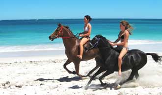
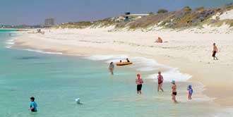
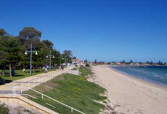
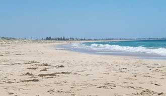
There are more than a dozen suburban ocean beaches to choose from along the Perth section of the Sunset Coast, with wide, long ribbons of sand, broken by sections of small limestone cliffs and inner reefs. These make for some great swimming, body-boarding, surfing, snorkelling and fishing spots. The main leisure and nightlife centres are Cottesloe, Scarborough and Hillarys Boat Harbour; Swanbourne Beach is popular with naturists. In summer it is best to visit the beaches in the morning before the breezes come.
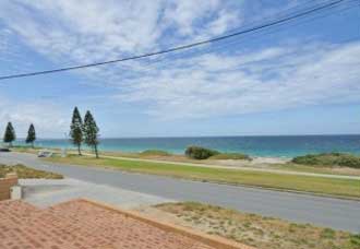
The beaches to the north of Fremantle are surf beaches; those to the south generally have calmer water, being they are relatively sheltered by the offshore islands, and are particularly suited to families with young children.
All of Perth’s ocean beaches face west, thus they receive plenty of afternoon sea breezes (be careful of wind burn) and offer the beautiful over-the-ocean sunsets that give the Sunset Coast its name. Picnic dinner on the beach as the sun goes down is always a special experience. All have clean white sand, often backed by sand dunes. The water is clear, clean and great for splashing, body surfing or boogie boarding. Some beaches also cater for kite and wind surfers as well as rock and surf fishermen.
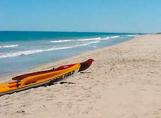
Rips do occur so remember to swim between the flags on beaches patrolled by lifeguards. Most beaches have extensive parking, and many have cafes, shops and shaded picnic facilities. Public transport access is by bus from the city. Cottesloe, Leighton and Port Beach can also be reached by rail on the Perth-Fremantle line.

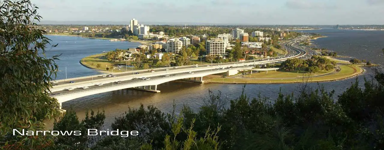
– north of Fremantle
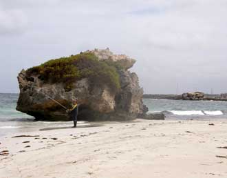
Two large limestone rocks on the beach here.
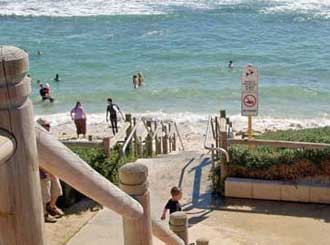
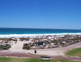
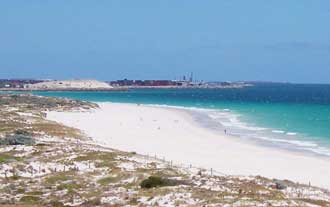
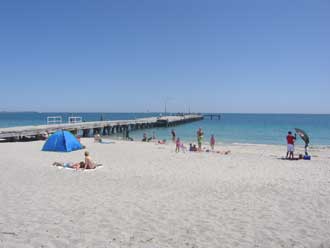
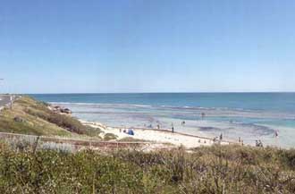 Yanchep Logoon
Yanchep Lagoon is a small ocean lagoon protected by a reef. Alongside the lagoon is an open surf beach, making it the perfect choice if some family members want to swim in protected seawater and other in open surf. The name Yanchep is of Aboriginal origin, and is derived from ‘yanget’, a native flax or bullrush.

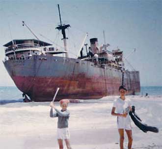 Wreck of the SS Alkimos in 1963. Photo: WA Museum/ Stanley Perkins Collection
Alkimos Beach is named after the 7033 ton Greek freighter Alkimos which rang aground here on 19 March1963. Several attempts were made to refloat her, but all were unsuccessful. The ship took some years to break up. As of April 2007 the structure was almost fully disintegrated above the water line to the point where only the engine block is visible from the beach. There is no road access to this beach, and the only way to approach it from land is by four wheel drive vehicle, however a coastal village is planned.
Burns Beach is named ater a farmer who ran sheep in the area in the late 19th century. The suburb which takes its name from the beach is located on land originally owned by the Midland Railway Company. It was developed in the 1980s.
Ocean Reef, located within the City of Joondalup, is Perth’s most northerly suburban beach. The name was coined by developers in the 1970s from the line of a reef visible several kilometres offshore. Ocean Reef Boat Harbour has been developed into an entertainment centre to help with the overspill from the popular Hillarys Boat Harbour development to the south. A dune walkway and cycle path hugs the coast from south to north, offering access to several small beaches, picnic areas, rest stops, and access paths into the suburb itself.
Mullaloo has a surf lifesaving club and a hotel with an excellent oceanside bar and restaurant. Both beaches have parking and shaded grassed areas for picnics. As with all of Perth’s northern beaches, the sand is white and clean and the water crystal clear.
Whitfords and Mullaloo Beaches are to the north of Hillarys Boat Harbour and Pinnaroo Point. The name recalls Frank Whitford, a developer whose plan for the development of a large tract of land he owned in the area between Mullaloo and Waterman Bay was first presented in 1928, and came to fruition 43 years later. In 1971, as a direct result of the adoption of the Corridor Plan for the development of Perth, Frank Whitford’s development plan was given government approval in principle. Whitford’s name was adopted for the first suburb in the North corridor that would ultimately house 50,000 people.
The development was eventually broken down into four suburbs – Craigie, Padbury, Hillarys and Kallaroo – with the name Whitfords being retained for the beach, the shopping centre and major road through the area. Attempts are afoot to close down Whitfords Horse Beach, and to extend the existing Dog beach.
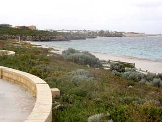
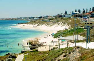
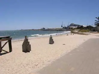
 Hillarys beach and Boat Harbour
Hillarys Boat Harbour is a great spot to spend the afternoon shopping, sightseeing or relaxing in a cafe. The Aquarium of WA and Rottnest Island Ferry are also at the harbour with world class golf courses, major shopping centres, cinemas, Arena Joondalup and Challenge Stadium sporting facilities, all nearby.
The clean sands of Sorrento Beach are within walking distance of Hillarys Boat Harbour. Sorrento is one of Perth’s traditional northern beach suburbs and the site of the Sorrento Surf Life Saving Club. One of three 50 m long rock groynes on this strip of coast separates Sorrento Beach from Marion Beach. the groynes were built to stop beach erosion. There is a large car park off the highway adjacent to the surf club. Today the surf club with its high watchtower sits between two of the groynes, with a seawall fronting the club and car park.
West Coast Highway runs along the top of the bluffs and the Marmion Angling and Aquatics Club overlooks the southern end of the beach. A small car park is located towards the northern end.
Waterman Beach on Waterman Bay was one of the earliest of Perth northern beaches to be developed as a residential locality. The beach is relatively small, and placed between two rocky outcrops. First settled in the 1860s, Waterman served a stopping point and Star Swamp a watering hole along the Coastal Stock Route to Geraldton. Named after Alfred Waterman, a local fisherman and one of the first residents in the area.
In 1918, the area was subdivided as the Mt Flora Estates, but initial development was largely limited to holiday shacks. After World War II, the area developed rapidly. The suburb’s name was shortened from Watermans Bay to Waterman in 1962, but this was never popuklar and it reverted to Waterman Bat in 2003.
The name has been in use for the area and the beaches in the area since at least the 1880’s, when the Hamersley family built a summer home there. Streets in the area honour members of the family. It is a descriptive name, derived from the beach being (at the time) the most northerly of Perth’s beaches. North Beach is home to a series of small beaches separated by small limestone headlands and reefs.
Each of the beaches has its own name. Bennion Beach, just north of Trigg, is the most isolated of these. Mettams Pool and Hamersely Pool are the most popular spots. There is a disabled access fishing platform at North Beach. Marmion Beach and Waterman Beach are to the north. Parking is generally kerbside on West Coast Highway, which runs alongside the coast; shops and cafes occur at regular intervals on the road.
Hamersley Pool is named after the district’s first land owner, Edward Hamersley, who owned and farmed land near Guildford. In the late 1800’s he built a summer home in what is now North Beach, and named it "The Castle". It was on the site of the present day Castle Hotel. Hamersley Pool, at the southern end of North Beach, is one of the most popular swimming spots on this section of coast.
North of Trigg Island the coast changes from the wide sandy beaches of Scarborough and Trigg to rocky bays. Some of the better known of these bays include Mettams Pool, a swimmer friendly area which is extremely popular with early morning swimmers of all ages, North Beach and Watermans Beach. Mettams Pool is a protected rock pool situated inside a protecting reef.
Bennion Beach is a small beach, perfect for snorkelling and rock hopping. There is an abundance of marine life on the reef systems surrounding the beach, with a sheltered swimming area. There is a secluded atmosphere to the beach as most people swim at Trigg, a short distance to the south.
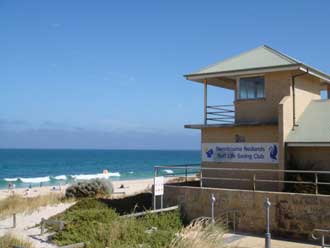
Trigg has traditionally the most challenging surf on the suburban beaches strip around what remains of Trigg Island, which is a rocky outcrop on the shoreline. Trigg is also well known for the Trigg blue hole, an area at the north end of Trigg Beach which has in the past claimed several lives. Trigg has a surf lifesaving club, grassed areas, kiosks, off street parking, public toilets/change rooms, small boat launching ramp. Trigg was named after Henry Trigg, Superintendent of Public Works in the Colony of WA from 1838 to 1851.
Scarborough is one of Perth’s best surf beaches. Scarborough has a wide array of visitor accommodation as well as shops, cafes and a vibrant nightlife. It is a popular spot for wind and kite surfing. Facilities include a surf lifesaving club, good parking and large grassed areas. Beaches within walking distance include Trigg Beach (surfing, fishing) 1.4km north with its island and rock pools, and Brighton Beach to the south where topless beach babes go to work on their suntans. The name is derived from the name of a residential subdivision which began to be sold in the late 1880s. The name was coined by a real estate developer and recalls the English seaside town of Scarborough in North Yorkshire.
The name is derived from the name of a residential subdivision to the South Scarborough Beach Road. The name was coined by a real estate developer and recalls the English seaside resort town of Brighton in Sussex. The name was never adopted officially and the subdivision is now part of the suburb of Scarborough.
Floreat Beach is the southern end of a long ribbon of surf and sand that is begins at Scarborough and encompasses Brighton Beach. The whole of the beach in this area was once known as City Beach, but this section was re-named in the 1940s to differentiate it from City Beach. Floreat Beach does not border the suburb with which it shares its name. The name is derived from the residential subdivision of Floreat Park. Perth’s Town Clerk, W.E, Bold, chose the name, which is a Latin word meaning ‘Let It Flourish’. It was taken from Perth’s Coat of Arms. Subdivision of Floreat Park (known simply as Floreat since 1977) commenced in 1912. The name was adopted for Floreat Beach in the 1940s to differentiate it from City Beach, both of which still fall within the boundaries of the City of Perth, however Floreat Beach does not border the suburb with which it shares its name.
City Beach is generally considered by the locals as Perth’s best surf beach. It is a wide ribbon of beach backed by shaded grassed areas with plenty of parking, picnic shelters, a kiosk, children’s play facilities and a surf lifesaving club. To the north of the groyne is Floreat Beach, which is generally less crowded in the middle of summer. It has its own surf club and car park.
The name City Beach was first used as the name for all the beach area within the boundaries of the local government area of the City Of Perth. After World War I the City Council proposed to lay out an up-to-date seaside town near the ocean beach on garden city lines, embodying approved Town Planning principles, and making ample provision for recreation purposes.
Swanbourne is also well-known for having the only nudist beach in Perth. The nudist beach is situated on what was once army land and was thus not subject to local council authority. Its status as a nude beach has been protected in recent years by the efforts of regular users. It is immediately north of the officially named Swanbourne Beach. There is a surf lifesaving club and plenty of parking at the main Swanbourne Beach at the end of North Street. Can be accessed by train, alighting at Swanbourne station, but includes a 1.6km walk north along Servetus Street, then left into North Street.
The name recalls the home of the first Baron Cottesloe of Swanbourne, Buckinghamshire, England, the brother of Captain Fremantle. A section of North Swanbourne Beach is designated for use by nudists. The name came into use for the beach and the first homes nearby which began to be built in the 1890s. The beach and the suburb which shares its name were named simultaneously.
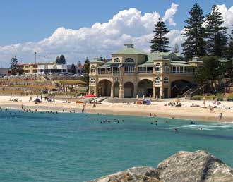
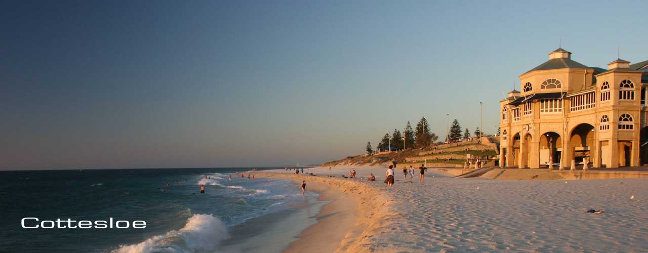
Cottesloe Beach has terraced lawns and a magnificent Indiana Tea House set right on the beach. Here, towering Norfolk pines line a boulevard buzzing with cafes and pubs. It’s a great place for early-morning breakfast beside the Indian Ocean, or if you have more time, a refreshing sunset beer at the pub. Cottesloe and North Cottesloe both have surf lifesaving clubs. Access by train, alighting at Cottesloe station and walking 800m along Forrest Street to the beach.
The name recalls the first Baron Cottesloe of Swanbourne, Buckinghamshire, England, the brother of Captain Fremantle. The beach and the suburb which shares its name were named simultaneously when the townsite of Cottesloe was declared by Gov Broome. Up until the time of the duplication of the railway line in 1898, what is today Cottesloe station was known as Butler’s Siding.
Mosman Beach takes its name from the nearby suburb of Mosman Bay, which was adopted by the Buckland Hill Road Board in October 1907. The area was previously known as Buckland Hill. Confusion still exists between between the river beach on Mosman Bay and the ocean beach of Mosman Beach, the common belief being that the name ‘Mosman Beach’ refers to the river beach. Mosman Beach is located to the south of the Vlamingh Monument and lookout, where Dutch explorer Willem Vlamingh is believed to have come ashore on 5 January, 1697. The beach to the monument’s north is South Cottesloe.
Port and Leighton Beaches are quite close to Fremantle Harbour’s North Quay wharf facilities but are not affected adversely by them. The sand is still very clean and small waves. Facilities include shelters, toilets and a surf lifesaving club with a few eating establishments close by. Access by train, alighting at Mosman Park, Victoria Street, Leighton or North Fremantle stations.
Leighton Beach takes its name from a railway station on the Perth to Fremantle line near the beach. The station was named after John Leighton, one of Perth Railways Department earliest employees who worked first as a letter carrier between Perth and Fremantle in 1867 and then as a storeman when the Railways Department was created. His home was in Harvest Road, North Fremantle, his wide operated the crossing gates at Leighton Beach between 1881 and 1895. The Leightons were the first European residnts in the area.
Bathers Bay
Located between Marquis Head and the Fishing Boat Harbour, Bathers Bay is a small beach in the heart of the oldes section of Fremantle. It is a popular spot for families with small children, particularly as in the morning it is sheltered. In the afternoons though, it is a different story – the Fremantle Doctor blows in to cool the city and it provides the strong wind for one of the best international sailing venues around.
It was here on 2 May 1829 that Capt. Fremantle made his first ladding with the Swan River Colony’s pioneer settlers and took formal possession of the whole of the West Coast of what was then called New Holland for the British crown. The beach continued to be the main access point ton the colony until the inner harbour was completed in the 1890s.
South Beach at South Fremantle is the closest beach of any significant size to the port city of Fremantle. South of Success Harbour, South Beach has plenty of parking and a grassed area between the groynes. There are views to Garden and Carnac Islands, which shelter the beach from choppy conditions, and plenty of cafes and restaurants nearby. The name came into popular use in the 1850s, originally as a reference to all the beaches to the south of Fremantle.
O’Connor Beach is at the southern end of the South Beach, and is is the most pleasant. It can be accessed via McTaggart Cove Road alongside the old South Fremantle Power Station. Around the corner from the groyne at the southern end of the beach is the McTaggart’s Cove natural pool. CY O’Connor Reserve has modern picnic facilities.
Located at the southern end of the South Beach, beyond the Catherine Point groyne, O’Connor beach is most pleasant. It can be accessed via McTaggart Cove Road alongside the old South Fremantle Power Station. Around the corner from the groyne at the southern end of the beach is the McTaggart’s Cove natural pool. The beach is named for Charles Yelverton O’Connor, a forward thinking engineer who was responsible for designing Framantle Inner Harbour, the Perth suburban railway system and the Goldfields Water Supply pipeline. O’Connor committed suicide at the beach on 10 March 1902 after intense criticism from the media that the Goldfields Water Supply project was a waste of money and would not work.
Coogee is a calm water beach equipped with camp grounds, deluxe units, chalets, family units, motel rooms, and powered caravan sites. There’s also walking paths, a newly built jetty and jet ski rentals. Its not as crowded as some of the beaches closer to Perth (it is 22km from the city centre), and perfect for the family. The Coogee Beach Festival, the last of the City of Cockburn’s Summer of Fun events, is held on a Sunday every March.
The name is of Aboriginal origin and was first recorded by local settler Thomas Watson as the name for Lake Munster. This name gradually gave way to the more widely used Aboriginal name Lake Coogee.
Woodman Point is some 8km south of Fremantle along Cockburn Road. It has an intriguing history and features in Nyoongar creation stories. Behind Jervoise Bay beach is the John Graham Recreation Reserve. Nearby are numerous historic sites from the period when Woodman Point was used as a Quarantine Station and ammunition store. The beach has not been legally approved for skinny dipping but nude bathing occurs here. It is quite large and in two sections – one north of the point on Owen Anchorage, and another south of the point on Jervoise Bay. More
Woodman Point was named by James Stirling in March 1827 after Thomas Woodman, purser, HMS Success. Originally Woodman’s Point. Jervoise Bay was named by James Stirling at the same time after Capt. Jervoise, HMS Success.
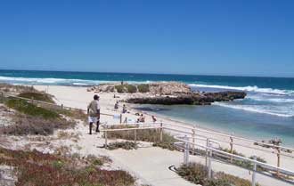
 Challenger Beach boat ramp
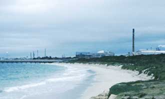
Challenger Beach is located south of the Henderson shipbuilding complex. Sandwiched between the Henderson and Kwinana industrial areas, swimming here is a far more pleasant experience than one would expect. The beach receives waves reaching up to 1 m, which maintain a narrow attached bar. It is backed by a 50 m wide grassy dune, then a large aluminum refinery. Facilities consist of a car park, toilets and a small boat launching ramp off Sutton Road.
Challenger Beach was named after HMS Challenger, which, under the command of Capt. Charles Fremantle, sailed from England to the Swan River to take possession of the west coast of New Holland. Capt. Fremantle claimed possession in December 1828.
Kwinana Beach is surrounded by heavy industry such as oil and aluminium refineries, and the northern area were these occur is generally closed to the public. The southern section, just north of Rockingham, is quite accessible with calm water to swim in and to watch the big ships come and go. It has a jetty, a boat ramp. Wells Park is a popular place for family picnics and get-togethers. The beach faces due west but is shielded by Garden Island from ocean swell, receiving only low wind waves and occasional low swell.
The name recalls the State Ship Kwinana, which traversed between Fremantle and the ports of the north-west of Western Australia between 1912 and 1920. It was destroyed by fire at Carnarvon in 1920 and was towed to Cockburn Sound. It broke loose in a gale and ran aground on 30 May 1922 on the beach which bears its name. Cottages built near the wreck soon adopted the name Kwinana. The name is of Aboriginal origin from the Kimberley region, and means ‘fair maiden’.
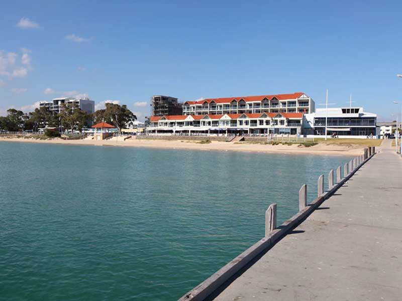 Rockingham
The Mangles Bay foreshore at Rockingham stretches approximately 4 to 5 kilometres with calm and safe beaches. At Rockingham there are well manicured, shady, grassy lawns with free electric BBQs and great children’s playgrounds and a good selection of cafes. The name recalls the ship Rockingam, which ran aground in May 1830 on what is today known as Rockingham Beach. It was the last of three ships to sail from London with Thomas Peel’s settlers. Capt. Dance of HMS Sulphur came to its aid but attempts to re-float and repair the ship failed.
 Safety Bay
The Shoalwater Islands Marine Park contains the waters of Shoalwater Bay, Warnbro Sound and a part of Cockburn Sound off Cape Peron. The park encompasses a diverse marine environment and surrounds a chain of unique limestone islands which are significant in the ecology of a number of bird species. The area is great for boating and swimming and there are good surfing conditions off the western edge of Penguin Island. Tours of the islands, which include visits to seal, sea lion and little penguin colonies, are conducted from Mersey Point. There are numerous clean, calm water beaches on Shoalwater Bay and Safety Bay.
Warnbro is a delightful beach to the south of Rockingham and Point Peron on Warnbro Sound. It is approximately 30 minutes by car from Perth. The yellow sand is quite fine but clean and forms dunes behind the beach. The beach shelves very gently and does not usually have large waves so the swimming is safe for all the family. A nude section of the beach is some 900m long and has been clearly marked with signposts. More info
The name is derived from the nearby residential subdivision. Approved in 1984, the name was used for a propsed marina development which was to include a small boat harbour. The suburb does not now include a harbour.
 Golden Bay Beach
South of Warnbro are a string of beaches that stretch all the way to Manduarh. These include waikiki, Secret Harbour, Golden Bay, Singleon, Madora Bay and Watersun. The name is derived from the nearby residential subdivision. The name was coined by a real estate developer. Previously named Peelhurst, Golden Bay was approved as a suburb name in 1985. It is derived from the golden sands of the beach there.
Singleton is named after the nearby locality, which in turn is named after Captain Francis Corbet Singleton who came to and settled in this district in 1839. Singleton was appointed to the first Board of Road Directors in 1840, and had extensive lanholdings in the Murray District. Singleton was declared a townsite in 1956.
The name was coined by a real estate developer for the Madora Beach Estate, a nearby residential subdivision which was subdivided and sold in 1960. The estate was a development of Perrys Estate Agency in Mandurah, and the name was derived from two Western Australian place names: Chadora, a mill and railway siding near Dwellingup, and Mandora, a cattle station between Broome and Port Hedland. The suburb’s name was first approved as Madora in 1990, and amended to Madora Bay in 2003.
The name is derived from the nearby residential subdivision. The name was coined by a real estate developer and recalls the city of San Remo on the Mediterranean coast of western Liguria in north-western Italy. It was approved as a suburb name in 1989.
The name is derived from a nearby residential subdivision. The name was coined by a real estate developer but is no longer used for the subdivision or suburb.