
Situated on Georges Bay, St Helens is the largest town on the north-east coast of Tasmania. A popular resort for fishing, swimming and other aquatic activities, its position makes St Helens a good base from which to explore the whole north-east corner of Tasmania. The town is famous for its crayfish, scallops, abalone and flounder. The Scamander River is noted for its bream.
St Helens' economy is dependent on fishing, timber and tourism. And, when it comes to tourism, the town prides itself in its warmth and sunniness - the result of a microclimate produced by surrounding hills and warm ocean currents. Consequently St Helens is warmer than Melbourne in winter and enjoys an average of 22°C in February. Such is the popularity of the area that it is estimated the population increases tenfold in summer.
Events
St Helens Game Fishing Classic is held every March.
Lookouts
St Helens Point is an elevated headland from which magnificent views of the coast can be obtained.
Where Is it?
St Helens is 256 km north east of Hobart via Midland, Esky and Tasman Highways, and 160 km east of Launceston via Tasman Highway (via Scottsdale) or Eask and Midland Highways (via Conara).
Visitor Centre
61 Cecilia St. St Helens. Ph (03) 6376 1999

Things To See And Do

Georges Bay
Georges Bay has 50 km of shoreline. By the 1830s Georges Bay was being used by whalers and sealers. Not surprisingly the settlement which grew up on the shore became known as Georges Bay and the local Aborigines became known as the Georges Bay tribe. Today, the bay is well used for recreational purposes. It is a very popular spot for boating and fishing, and there are plenty of sheltered coves and bays where families can swim and children play in its waters. The ocean beaches of St Helens Point are popular with surfers.

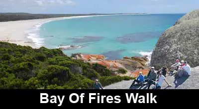
Bay of Fires
A short journey north from St Helens along and coast brings you to Binalong Bay and Bay of Fires and Eddystone Point beyond. Bay of Fires is world renowned for its giant granite boulders covered in orange lichen and white sandy beaches (they are often named among the best beaches in the world). This whole coast is popular with divers because of its kelp forests and underwater caves.

Mt William National Park
North of Binalong Bay along a very corrugated dirt road is Mt William National Park to Eddystone Point, where there is a lighthouse and the oldest standing lighthouse keeper residences remaining in Tasmania. Eddystone Point is close to Cape Portland, the most north easterly tip of Tasmania. Inland from Eddystone Point is Little Blue Lake, the brightest and prettiest blue colour you’ll ever see. The lake has been formed due to early tin mining and the exposed white clay reflects the sky, giving the water it’s colour.


Surrounding Area

St Columba Falls
St Columba Falls, the largest waterfall in Tasmania’s north-east, is 39 km east via Pyengana. Beyond the falls is an amazing forest of huge ‘Man Ferns’ (Dicksonia antartica). Here the track crosses a little creek where the rocks and logs are completely covered in mosses and little ferns. Bsides St Columba Falls, the small village of Pyengana is known for its quirky cheese factory.

Ben Lomond National Park
The magnificent mountain of Ben Lomond with its imposing and
precipitous cliffs is visible over much of the northern midlands of
Tasmania. The plateau is roughly 14 kilometres in length, 6 kilometres
wide and is in excess of 1300 metres in height. A summit on the plateau
named Legges Tor is the second highest point in Tasmania (1572 metres).
Ben Lomond is the main focus of downhill skiing in Tasmania. The
skifield on Ben Lomond is Tasmania's only downhill skiing area which
offers some of the facilities expected of a contemporary skifield.

Blue Tier Reserve
The Blue Tier Reserve is an exposed plateau with a rich mining and natural heritage. What makes the Blue Tier Forest Reserve so interesting is its long history in mining and forestry operations. The first Europeans came to this area after some miners who were working in the Mathinna goldfields discovered some rich tin deposits in some of the creeks in this area. The Blue Tier area also has a history in forestry operation. From 1945 to 1952 two sawmills were in operation with one run by a French family who milled celery top pine; while the Nichols mill focused on myrtle. There is a range of walks from a short 400m circuit, which is wheelchair friendly, to a 10.5km walk one-way to Weldborough for the more adventurous.
Major Attractions

Surrounding Towns
- Binalong Bay
- Pyengana
- Scamander
- St Marys
- Cape Portland
- Bay of Fires
- Mt William National Park
- Blue Tier Reserve
- Ben Lomond National Park
Regional Attractions
Recommended Accommodation


