
Once a quiet seaside village of holiday shacks, Dawesville is today a suburb of Mandurah. Being located between the Harvey Estuary and the Indian Ocean, it is surrounded by water. The Estuary side is a more established suburb which is quiet and friendly, offering keen boaters the doorway to the Peel Inlet.
The Harvey Estuary and the Peel Inlet combine to produce an array of fishing and crabbing options in the summer months. However, due to the crab population declining over the past half-decade, September and October and now banned from crabbing in the estuary.
Attractions outside crabbing and fishing include canoeing,jet-ski and skiing, whilst being only 500 metres from the beach over the highway is another attraction. Pyramids Beach, the most popular beach in Dawesville, is currently undergoing development of the beach to make it a future surf spot.
Port Bouvard
Port Bouvard is the general name given to the precinct around the famous Dawesville Channel (also known as the Dawesville Cut), and forms part of the southern section of the resort city of Mandurah. With its magnificent waterways and pristine coastline, the area is a haven for all who enjoy a coastal lifestyle. With beautiful canal homes, international links golf course and instant access to the superb Peel – Harvey Estuary systems, as well as the Indian Ocean via the Dawesville Channel, Port Bouvard is one of the jewels in the Mandurah crown.
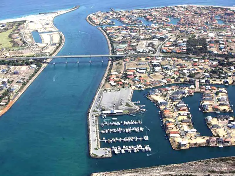
Dawesville Channel
Dawesville Channel (also known as Dawesville Cut) is a man-made channel between the Peel-Harvey Estuary and the Indian Ocean at Dawesville about 80 km south of Perth in Western Australia. It is just south of the regional city of Mandurah and just north of Yalgorup National Park.
Where is it?
Dawesville is 17 km south of Mandurah, 87 km south of Perth, 91 km north of Bunbury.
The channel was constructed to alleviate an environmental problem which had developed where much of the 136 km?, two metre deep estuarine system had become eutrophic. The adjoining estuaries’ ability to support the natural flora and fauna had become seriously degraded and the smell of rotting algae, particularly during the summer months had caused increasing complaints from residents. Stocks of the normally abundant fish and crabs had become depleted and recreational use was impacted. The deteriorating environmental situation became a major political and environmental issue for the Government of Western Australia during the mid-1980s.
The channel allows seawater from the Indian Ocean to regularly flush in and out of the estuary using the daily tidal movements which in turn prevent the build up of algae. The channel’s construction commenced in 1990 and was completed in April 1994. It is about 2.5 kilometres long, 200 metres wide and between 6 and 6.5 metres deep. Construction involved the excavation of about 4.5 million cubic metres of material. In addition to the excavation work, construction of breakwaters, training walls, a bridge and installation of a sand bypassing system was undertaken.
The channel is spanned by the four lane Port Bouvard Bridge which forms part of the Old Coast Road which carries traffic between Perth and the southern coastal townships. Approximately 40,000 vehicles per day use the road. Major residential canal developments have been constructed off the channel including the suburb of Wannanup and a golf course. Since its opening in 1994 no blue-green algal blooms have occurred.
Book Vehicle Hire

Book Accommodation

Design by W3Layouts | Content © 2013 Phoenix Group Co. | Sales: phone 1300 753 517, email: [email protected]