| New South Wales: BUSHWALKS |
From rainforest to desert; from mangrove swamp to alpine meadow; from coral reef to coastal heaths to mountains of eucalypt forests. Few other places in the world have the diversity of landscapes that New South Wales offers the bush or cross country walker. There are over two hundred national parks and reserves across the state, covering nearly five million hectares of land, all with walking tracks. Of these, more than twenty two national parks and over a million hectares of protected land lie within 150 km of Sydney itself, making the city a mecca for bushwalking. If you look on a map, a belt of green surrounds Sydney on all sides. Further afield, the coast of NSW and adjacent ranges are dotted with national parks and nature reserves.
Recommended Bushwalks
![]() |
Barrington Tops, NSW
Barrington Tops is full of contrasts. Carved out of an ancient volcano, it rises from near sea level to over 1500m. In the lower valleys, you'll find World Heritage-listed subtropical rainforests. Up on the plateau, there is sub-alpine woodland which regularly sees snow in winter. Most of the area is declared wilderness, and it's a well-known destination for bushwalkers. But the park is accessible even to those with limited mobility. Its excellent track network extends from short, easy walks to steep overnight treks.
Walking tracks | The Tops to Myall's Heritage Trail |
 |
The Blue Mountains: Because of its close proximity to the city of Sydney, The Blue Mountains are a mecca for both locals and visitors who enjoy bushwalking, canyoning or mountaineering to any degree of ease or difficulty. More than three million people come to Blue Mountains National Park each year. For many, it's enough just to find a lookout and gaze across the park's chiselled sandstone outcrops and hazy blue forests. Others walk or cycle along the cliff-tops and in the valleys, following paths that were created for Victorian-era honeymooners, or discovered by Aboriginal hunters many thousands of years ago.
Over 140 km of walking tracks of all grades (some accessible for people with a disability) in diverse settings make the Blue Mountains a bushwalker's paradise. Many walking tracks wind their way through the area. Above the walking tracks, the cliff lines of the Blue Mountains stretch for hundreds of kilometres and there are plenty of people who like to haul themselves up them. Canyoning is extremely popular in Blue Mountains National Park, where there are picturesque chasms to suit every skill level. The Grand Canyon Track, for example, can be enjoyed without without specialised equipment or skills. With some 400 canyons, Sydney canyoners are certainly spoilt for choice here.
Associated pages: Blue Mountains Guide | Waterfalls | Lookouts
Related websites: Adventure recreation | Walking tracks | Canoeing | Walking track notes | Wentworth Falls walks | Canyons in The Blue Mountains | The Six Foot Walking Track |
![]() |
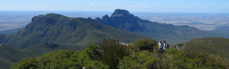
Warrumbungles National Park
The Warrumbungles, located in inland northern New South Wales, were part of a shield volcano that was active from 18 to 15 million years ago. The main features of the Warrumbungle mountains are a series of huge, jagged outcrops, surrounded by hilly bush and woodland forest. The Grand High Tops is a section of the range where volcanic remnants are especially clustered. These vents and rocky formations are all named - Belougery Spire, Belougery Split Rock, Crater Bluff, Bluff Mountain, The Breadknife and Mount Exmouth. The Breadknife, a straight wall of jagged rock nearly 100 metres high, is particularly rare. There is an extensive network of nine walking tracks across the central peaks.
Associated pages: The Warumbungle Ranges
Related websites: Warrumbungle National Park | Bushwalks | Bluff Mountain Circuit | Photos |
![]() |
Bouddi National Park
A small park lying on NSW's Central Coast about 60km north of Sydney, on the north side of the mouth of the Hawkesbury River and Broken Bay. It protects an area of coastal heath and moors, as well as a number of delightful beaches and Aboriginal rock art sites. The park can be reached by car or by bus from Gosford or Woy Woy station, or by ferry from Palm Beach to Wagstaff. Numerous short walks can be done from the park boundaries to the various beaches of Maitland Bay, Putty Beach, Little Beach and Tallow Beach. Longer walks often involve some road walking or a car shuffle, but good loop walks to Maitland Bay can be done via Putty Beach or Little Beach.
Related websites: About the park | Bouddi Wild Walk | Putty Beach and Maitland Bay walk |
 |
Wollemi National Park
This is the largest wilderness area in NSW and forms part of the recently declared Greater Blue Mountains World Heritage Area - a maze of cliffs, canyons and undisturbed forest. As an area for adventuring it is almost without peer. Few people venture more than a handful of kilometres from the boundaries of the park, and as a result there is an intense feeling of remoteness once you head into the interior. Weeks can be spent bushwalking, canyoning, liloing and climbing in various areas of Wollemi.
There are historic ruins at Newnes, across the Wolgan River from the camping area. The Glow Worm Tunnel is part of the old railway that serviced the area; access is from Clarence on the Bells Line of Road. Dunns Swamp has easy walks and plenty of opportunities for canoeing. Backpack camping is permitted throughout the park. Bookings and permits for camping are not required. Wollemi National Park is 100-250 km north-west of Sydney.
Related websites: 9 recommended walks | 5 Colo River Gorge walks |
![]() |
Mt Warning, NSW
Towering over the town of Murwillumbah and the Tweed Valley in far north-eastern New South Wales, is Mount Warning, the central core of the Southern Hemisphere’s largest extinct shield volcano. Named "Wollumbin", meaning "cloud catcher", by the Bundjalung people who inhabited the region before European settlement, it is the first place on Australia’s mainland to be touched by the morning sun. A climb to the summit to watch the dawn of a new day is a must for the adventurous. Allow at least two hours to climb and two hours to return for the 8.8km walk; good non-slip footwear is essential. There are resting points along the way.
The shorter (15min) Lyrebird Walk leads to an elevated platform in the palms where you can sit and experience the serenity and mystique of the rainforest. Walkers are advised to keep to the formed tracks, as it is very easy to become lost in the rainforest.
More >> |
![]() |
Eagles Nest Track, New England NP, NSW
New England National Park, in the New England region of Northern New South Wales, is a spectacular landscape on the edge of the Great Escarpment with panoramic views all the way to the coast. Numerous walking trails allows visitors to explore the Gondwana Rainforests of Australia World Heritage Area on a network of walking tracks. Eagle Nest Track is a climb down into the ageless world of Gondwana Rainforest where water drips down cliffs, and huge mossy Antarctic beech trees tell of countless damp and misty seasons. Icicle chandeliers may form at Weeping Rock in the depths of winter. The contrasting return is through snowgum woodland carpeted with snowgrass tussocks and colourful wildflowers. The waks starts and finished at Point Lookout, which offers wilderness views and sensational sunrises. It is a 2.2km loop which takes an average of 2 hours. There is a degree of difficulty (see Walking Tracks link below for easier walks).
New England National Park walking tracks
|
![]() |
Hidden Habitats Walk, Dorrigo Plateau, NSW
The Hidden Habitats Walk, also in The New England National Park (see "Eagle Hawk Track" above), passses through a truly fascinating environment, recognised internationally on the World Heritage list as part of the Gondwana Rainforests of Australia.From Banksia Point, the walk wanders through Antarctic beech rainforest to the exposed heath of Wrights Lookout. It returns via Thungutti camping area and the Tea Tree Falls Walk to experience rare sphagnum swamps and tall wet forest. The guided walk requires a medium level of fitness (over 8 kilometres including some steep and rocky terrain) and is not suitable for small children. Fees apply.
More >> |
![]() |
Kiama Coastal Walking Track, NSW
This 6km walking track is a dramatic, coast-hugging route from Loves Bay at Kiama Heights to Werri Beach at Gerrigong on the NSW South Coast. Those who know this coastline will be aware that the walk passes by some of the most scenic coastal vistas in New South Wales. As well as spectacular views, the walking track provides public access to previously inaccessible areas including gravel beaches, sea caves, scenic cliff tops and popular swimming and fishing spots such as Campbells Hole.
Map and brochure |
Bushwalking Clubs
Online bushwalking and trail guides
NSW Bushwalking online: Wild Walks | Bushwalks in NSW's National Parks | Hiking the Budawangs | Wombat Hiking Club walk reports | Canyoning near Sydney | David Noble abseiling, bushwalking and canyoning notes
Bushwalking tracks and information by state: NSW | Vic | Tas | SA | WA | NT | Qld | ACT
Australian hiking and bushwalking websites
|
|