| Western Australia: BUSHWALKS |
As Western Australia is such a vast state, covering numerous climate zones, we have broken the featured bushwalks into the state's three major geographical regions - the Kimberley (far north); central (including the North-West, Pilbara, Murchison and Gascoyne regions); southern (south of Perth). The walks featured are typical of what you can expect if you intend bushwalking in those regions. For bushwalk in and around Perth, please visit our Perth Travellers Guide.
Recommended Bushwalks: Southern
![]() |
John Forrest National Park: A few generations ago, this John Forrest National Park was the place to go in Perth for a family picnic; trainloads of passengers would alight at National Park station every weekend. Sadly, those days are no more. Trains stopped passing through the park in 1966 when a new standard gauge line was re-routed further north. The old lines were pulled up and the path the train took was converted into a walking trail. It is one of the best trails in the park, giving access to the old railway tunnel, a number of waterfalls and views across the valley towards the city of Perth. More ... |
![]() |
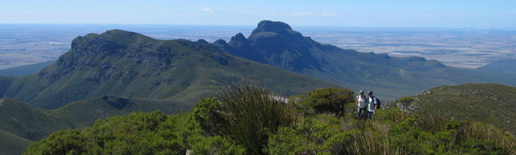
Bluff Knoll: The Stirling Range is a series of craggy peaks rising above a flat region of farmland to the north of Albany on WA's south coast. The range has been given National park status and is a significant botanical reserve containing a wide variety of altitude. Bluff Knoll, listed as one of Australia's 25 best hikes, dominates the landscape. At 1095 metres above sea level or 656 metres from the car park, it is the highest peak in the Stirling Range and indeed the whole southwest of Western Australia. With 360° views at the summit it offers ocean glimpses on a clear day. A well maintained walking track to the summit makes the climb to the top easier that it might otherwise be. Allow 3-4 hours for the 6km return trek. More ... |
![]() |
Pemberton Rainbow Trail: The Rainbow Trails is a 7 km track connecting the Big Brook Dam to the township of Pemberton along disused railway lines. This is a picturesque traill passing through Karri forest as well as farming land. The trail starts in town near the Pemberton Trout and Marron Hatchery. The Lefroy Brook flows along part of the trail, which is used as the water supply for Pemberton. The trail leads to the Big Brook Dam, which is a tranquil spot for birdwatching, picnicing or swimming on a hot day. The Rainbow trail forms part of the Bibbulmun Track from Pemberton to Beedelup. More ... |
![]() |
John Forrest National Park: A few generations ago, this John Forrest National Park was the place to go in Perth for a family picnic; trainloads of passengers would alight at National Park station every weekend. Sadly, those days are no more. Trains stopped passing through the park in 1966 when a new standard gauge line was re-routed further north. The old lines were pulled up and the path the train took was converted into a walking trail. It is one of the best trails in the park, giving access to the old railway tunnel, a number of waterfalls and views across the valley towards the city of Perth. More ... |
![]() |
Bluff Knoll: The Stirling Range is a series of craggy peaks rising above a flat region of farmland to the north of Albany on WA's south coast. The range has been given National park status and is a significant botanical reserve containing a wide variety of altitude. Bluff Knoll, listed as one of Australia's 25 best hikes, dominates the landscape. At 1095 metres above sea level or 656 metres from the car park, it is the highest peak in the Stirling Range and indeed the whole southwest of Western Australia. With 360° views at the summit it offers ocean glimpses on a clear day. A well maintained walking track to the summit makes the climb to the top easier that it might otherwise be. Allow 3-4 hours for the 6km return trek. More ... |
![]() |
Pemberton Rainbow Trail: The Rainbow Trails is a 7 km track connecting the Big Brook Dam to the township of Pemberton along disused railway lines. This is a picturesque traill passing through Karri forest as well as farming land. The trail starts in town near the Pemberton Trout and Marron Hatchery. The Lefroy Brook flows along part of the trail, which is used as the water supply for Pemberton. The trail leads to the Big Brook Dam, which is a tranquil spot for birdwatching, picnicing or swimming on a hot day. The Rainbow trail forms part of the Bibbulmun Track from Pemberton to Beedelup. More ... |
![]() |
Boranup Karri Forest: The Karri Forest at Boranup is small and isolated from the larger Karri forests, a hundred kilometres to the east. It nestles behind the Leeuwin Ridge and is just one of many remarkable surprises encountered in the Leeuwin-Naturaliste National Park in the state's south west. The forest is criss-crossed by numerous tracks and these can be used to make easy, though rewarding, circular walks of varying length. This walk starts and finishes at Lovespring road, just off Boranup Drive, and follows well defined tracks through re-grown Karri forest and some peppermint and banksia woodland. It forms a 15 kilometre circuit and takes 4 to 5 hours to complete. More ... | Boranup Beach and Forest |
![]() |
Railway Reserve Heritage Trail, WA
Frequently referred to locally as the 'Bridle Trail' or 'Bridle Track,' this very pleasant, easy 41 kilometre loop walking/cycle/horse riding trail follows the alignment of the old Eastern Railway from Bellevue to Chidlow in through the hills to the east of Perth. Once the main line from Perth to the Eastern States, trains ceased to operate on the Bellevue to Northam railway following the construction of a new Standard Gauge line to the north in 1966. The whole trail is in effect a vital Wildlife corridor creating connections between adjacent parks and nature reserves. Most who walk or ride the trail do it in easy-to-manage sections.
 |
Recommended Bushwalks: Central
![]() |
Dales Gorge and Circular Pool, Karijini NP: There are many supberb walks through the gorges of the Hamersley Ranges in Karajini National Park; this is one of the easier ones. The four kilometre walk trail runs along the bottom of Dales Gorge. Here you can go swimming in the stream, permanent water pools and beneath waterfalls. Lush green ferns and the occasional gum tree contrast with the red terraced cliffs weathered by time. Give yourself three hours to make the return journey. The two hour return hike to Circular Pool involves a loose steep descent and then an easy ramble. Here, you’ll find hidden gardens and a clear rock pool. You can see Circular Pool from a lookout on the Gorge Rim Walk. This walk follows the rim of Dales Gorge between Circular Pool Lookout and the beginning of the Fortescue Falls track. More ... |
![]() |
Murchison Gorge, Kalbarri: An 80km-long section of the Murchison River winds through a Tumblagooda sandstone gorge before entering into the sea near the town of Kalbarri. Kalbarri National Park protects this gorge which contains some of the most impressive red-and-white-banded cliffs and gorge scenery in Australia. A visit to Hawks Head Lookout, affords great views of the eastern sections of the Murchison River. Oxbow River bend The Loop, is beautifully visible through the amazing Natures Window. Pathways down from these lookout lead into the gorge and to the Murchison River.
More ... |
![]() |
Yardie Creek: The ancient Yardie Creek gorge has deep blue water, red limestone cliff faces and a wonderful array of birds and wildlife, including the rare black-footed wallaby, euros and red kangaroos. From the top, the views into the creek and out to the Ningaloo Reef are purely spectacular. The Yardie Creek walk trail is located in the spectacular Yardie Creek gorge, one hour's drive from Exmouth, Western Australia. Starting at river level the trail slowly climbs up the red rock cliffs of the gorge, becoming more difficult as you ascend the Range; however the views into the gorge are well worth the effort. More ... |
Recommended Bushwalks: Kimberley
![]() |
Cathedral Gorge, Purnululu National Park: The Bungle Bungle Ranges are an amazing geological formation consisting mainly of unusual beehive shaped and striped formations and deep gorges. Cathedral Gorge, known for its massive walls and amazing accoustics, is one such gorge. The walking trail is a 4km return from Piccaninny car park. The walk winds its way through the iconic bee hives, heading down between two walls of rock before opening up into Cathedral Gorge. Water pounding through here in the wet season has created a huge amphitheatre of red rock with a pool of water in the middle (bring a wide angle lens for your camera). The acoustics are so good that music has been played within the gorge. More ... |
![]() |
Emma Gorge: Just an hour's drive from Kununurra, Emma Gorge Resort is an oasis in the ruggedly beautiful East Kimberley. A magnificent natural swimming pool at the foot of a waterfall greets the visitor at the end of the 1.6 km walk through the gorge. The plunge pool is shaded for most of the day, so the water is usually very cold, but a small spring makes a two person spa on the eastern side. The beautiful turquoise pool 200m before the end is fed by more springs and is warmer. Emma gorge Resort is part of El Questro Resort; these is an entry fee to do the gorge walk. More ... |
![]() |
Tunnel Creek: This locality takes its name from the 750 metre long tunnel carved by flowing water out of the limestone of the Napier Range, and is part of the 375 to 350 million-year-old Devonian Reef system. The entrance is not far from the car park. To pass through it to the other side of Napier Range, you have to wade through long waterholes up your waist and at times up to your chest. In sections, it is pitch black so you need to carry a torch in one hand and your camera in your other. Tunnel Creek is miday between Derby and Fitzroy Crossing, and about 2 to 3 hours drive from each. It is 30 km south east of Windjana Gorge, so the two can be visited in one day. More ... |
Bushwalking tracks and information by state: NSW | Vic | Tas | SA | WA | NT | Qld | ACT
Australian hiking and bushwalking websites
|
|