|
You can experience the striking beauty of massive granite outcrops rising impressively across the landscape of the rolling farmlands in a little visited part of Western Australia - the Wheatbelt. An abundance of natural vegetation around these unique rock formations includes wandoo, salmon gum, dense honey-myrtle and tea tree thickets giving way to flowering granite Kunzea, with their gnarled shapes.
![]()
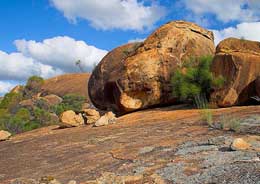
Beringbooding Rock waterhole
The journey is a memorable contrast of picturesque farmlands, rocky granite outcrops, vibrant floral displays stretching into the distance, tranquil picnic spots and a profusion of bird and animal life. This drive is a loop that starts and finishes in Perth.
Location: Eastern Wheatbelt, Western Australia
Length: 831 km
Suggested return journey:
Minimum duration: 2 days
Perth to Muckinbudin (280 km): Proceed to Goomalling via Toodyay. At Goomalling, travel cross country through Dowerin, Wyalkatchem, Traying, Kununoppin, Nungarin to Mukinbudin. Uberin Rock is a huge granite monolith offering scenic views and easy bushwalks and a natural picnic area. In season, dark green paddocks of wheat, barley and yellow canola can be seen from the top of the rock.
Explore the Tin Dog Creek Walk and Bird Hide near Dowerin. Still visible at Namelcatchem Reserve, 17 kilometres east of the town of Dowerin, are wagon wheel tracks made by travellers on their journey to the goldfields in the late 1800's. Korrelocking Reserve, near Wyalkatchem, is a sanctuary for kangaroos and other forms of animal and bird life indigenous to this part of the wheatbelt. It is a very popular picnicking place for local people especially during spring when it abounds with wildflowers.
Wildflowers and fauna are plentiful at Billyacatting Hill, north of Kununoppin. An interpretive walk trail enriches your visit to this Park. A reasonable level of fitness is needed as a rock climb is involved. Allow about two hrs for the whole walk. Talgomine Rock, east of Nungarin, has a variety of wildflowers and orchids on its eastern border. Climbing Mt Moore will reward you with an extensive view to the north with Lake Campion in the distance.
Mukinbudin to Beacon (114 km): Quanta Cutting, east of Mukinbudin, is a granite outcrop with an interesting large circular gnamma hole. When flowering, the Kunzea pulchella can be found in both the red and white varieties. Access to Chiddarcooping Nature Reserve, a grantie outcrop near Westionia is difficult and is best tackled by 4WD vehicle only. 75kms north of Westonia, Yanneymooning Hill offers spectacular views with a wonderful variety of bird life and flowers. The abundant, ornate dragon lizard (Ctenophurus Ornatus) is an entertaining feature of the Yanneymooning Rock.
Elachbutting Rock is a spectacular natural rock formation with similar features to Wave Rock. Elachbutting and Beringbooding are by far the most spectacular granite outcrops in the Wheatbelt. Elachbutting Rock has a number of large cavern areas and is surrounded by natural bushland. The rock is around 100km north of Westonia and is easily accessed via well maintained gravel roads.
Beringbooding Rock, north east of Mukinbudin, has the largest rock water catchment tank in Australia. It was built in 1937 by sustenance labour during the Great Depression. Beringbooding has an amazing balancing boulder, a huge gnamma hole and some of the Kalamaia Tribes paintings of hands in a cave at the rear of the rock. Two early pioneer wells are nearby.
From Beringbooding Rock, head towards the town of Bonnie Rock, named after the rock formation that is situated close to the town, then Beacon. The Tampu and Datjion Pioneer Wells near Beacon make for beautiful picnic spots during the wildflower season. The Beacon Botanical Park contains several species of native flora that were propagated from local areas. It is great for a quiet leisurely walk or an opportunity to select native plants that would suit your own garden.
Beacon to Perth (437 km): Billiburning Rock near Beacon is a favourite picnic spot. A good season results in white everlasting carpeting the ground as far as the eye can see. This Outcrop in Beacon provides excellent views of both cropping and pastoral country. The Outcrop is also the location of a pioneer well and Gnamma Hole. Travelling west from Beacon via the Bonnie Rock Burakin Road is Mollerin Rock. Wildflowers of many varieties proliferate in the Koorda district, with dazzling colour displays on roadside verges around Mollerin Rocks.
Return to Perth via Koorda, Wongan Hills, Goomalling and Toodyay. Wongan Hills flora is extremely diverse with more than 1400 species of flowering plants. Of greater importance is that 24 of these species are unique to the Wongan Hills.
Off the designated route are other granite outcrops:
Eaglestone Hill: Situated in the Nungarin Shire along Brown South Road, the Hill abuts Lake Brown. Patches of York Gum woodland abut the rock which has stands of red Kunzea pulchella adding patches of colour in late spring. Wedgetail eagles are often seen perched on the Rock.
Buckley's Breakaway: located 70 kilometres east of Kulin, off the Holt Rock Road with 11 kilometres of gravel road on-route to Wave Rock, Buckley’s breakaway is a picturesque landform where erosion has cut through the orange laterite and formed spectacular white cliffs and gullies from the underlying clay.
Merredin Peak: located off Benson Road in the townsite of Merredin. Merredin Peak is a naturally occurring outcrop of granites that are about 2,700 million years old. The Peak is set in an area of woodland known locally as Merredin's National Forest. Take the Merredin Peak Heritage Trail and explore the site of the Army Field Hospital. Interpretation on site.
Totadgin Rock: South of Merredin, Totadgin Conservation Park has a walk trail with interpretation and is a good first stop to find out how granite rock outcrops are formed and about the unique habitats they create. Wildflowers in spring. A Golden Pipeline Heritage Trail Site.
Sandford Rocks: Situated approximately 10 km north east of Westonia, Sandford Rocks Nature Reserve is 806 hectares of Granite outcrop, pools, wildflowers, scrub and woodland. It has many diverse species of flora and fauna.
Baladjie Rock: A popular picnic spot for locals and visitors, Baladjie Rock is located on the Koorda-Bullfinch Road 42 km north east of Westonia. The extensive granite outcrops are situated in an attractive woodland adjacent to Baladjie Lake. A climb up the main rock provides a spectacular view of the nearby lake system and surrounding landscape.
Beagley's Breakaway: A breakaway rock formation dating back millions of years, adjoining Tampu Well Reserve in the Mt Marshall Shire. This area is private property and vistors are asked to respect the owner's property, fences and roads.
Bruce's Rock: Situated 2 km from the town of Bruce Rock, there are two old wells located at the picnic site at the foot of the rock and good walks are to be enjoyed over the rock outcrop.
Gorge Rock: Located 20 kms towards Kondinin, from Corrigin, Gorge Rock is a natural pool which was once the swimming hole, before a pool was constructed in the townsite. Although no swimming is allowed today, the area is still worth visiting, and a good rest stop with natural bushlands making pleasant surroundings.
Frog Rock and Dam: Situated in the Yilgarn Shire south of the Great Eastern Highway from Moorine Rock, Frog Rock is a popular picnic spot. A small dam is located beneath a wave rock formation. Wildflowers abound in the spring.
Gorge Rock: Located 20 kms towards Kondinin, from Corrigin, Gorge Rock is a natural pool which was once the swimming hole, before a pool was constructed in the townsite. Although no swimming is allowed today, the area is still worth visiting, and a good rest stop with natural bushlands making pleasant surroundings.
Jilakin Rock: 20 kms east of Kulin on Holt Rock Road (follow the Tin Horse Highway), a shady picnic spot at the base of Jilakin Rock. An easy climb to the top provides spectacular views of Jilakin Lake and the surrounding Wheatbelt. Wildflowers form a wonderful display during August and September.
Keokanie Rock: Located 25 km north of Bodallin on the Bodallin North Rd , Keokanie Rock is a stop off place on the way to Baladjie Rock further north. An easy climb to the summit is rewarded by great views.
Kokerbin Rock: Situated 40 kms west of Bruce Rock. An unspoilt area where a visitor can explore features such as the Wave Wall, Dog Rock, Devil’s Marbles, panoramic views and a fascinating well at least 20 metres deep, three metres in diameter constructed by hand in the early 1920-30’s. Rocks were levered into the soil to line well walls. An amazing engineering feat similar to others built by pioneering drovers to water stock.
Yorkrakine Rock: Situated 25 kms north of Tammin the granite outcrop is 341 metres high and covers 160 hectares. The flora strip at its base is an important haven for flora and fauna. A great picnic spot with toilet facilities.
|