You are here: Home > Travelling Australia > Journeys > WA Cross Country Hikes and Walks
Great Australian Journeys


Western Australia
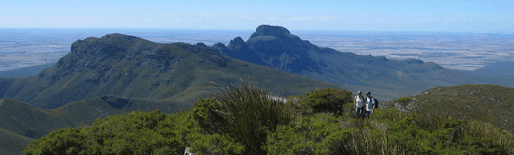
Being such a vast state, it is impossible to document here every track or path that it is possible to take on foot. That being said, Western Australia is blessed with a number of regions which have good walking if one is willing to venture off-track, the easiest to access being the south-west of WA, and it is on these that we will focus.

The Bibbulmun Track, WA
Discover towering forests, tranquil farmland and wild beaches on this award-winning walk through Western Australia’s south-west. The gold snake signs that mark the trail stretch almost 1,000 kilometres, from the Perth hills to Albany on the south coast. Scale Mt. Cooke in the Darling Range and lose yourself in the lush forest fringing the Darling River. Visit vineyards in the Blackwood Valley, walk next to waterfalls and wildflowers in Beedelup National Park and clamber over granite boulders on the Pingerup Plains. Walk through sky-scraping karri trees in the Valley of the Giants, swim from Peaceful Bay and watch migrating whales from Albany. Do the walk in sections, or mix and match day and multi-day treks according to your time, the scenery you want to see, and your energy.  Keep in mind it would take around two months to follow the snake markers all the way! The track is well-equipped, with hikers' huts or camping sites situated a day's walk apart. 965 km/up to 60 days/day and multi day walks.


Railway Reserve Heritage Trail, WA
Frequently referred to locally as the 'Bridle Trail' or 'Bridle Track,' this very pleasant, easy walking/horse riding trail follows the alignment of the old Eastern Railway from Bellevue to Chidlow in through the hills to the east of Perth. The Trail Loop (Bellevue to Bellevue via Mount Helena) is 40.8 km in length and constitutes two routes travelling east of Bellevue. The Eastern extension - Mount Helena to Wooroloo - is 22.5 km in length. Once the main line from Perth to the Eastern States, trains ceased to operate on the Bellevue to Northam railway following the construction of a new Standard Gauge line to the north in 1966. A pamphlet and signage on the trail notate the main stopping places, and the details go as far as Wooroloo. Sections of the reserve have important ecological features that contain examples of a range of conditions found in the region. The whole trail is in effect a vital Wildlife corridor creating connections between adjacent parks and nature reserves.

Cape To Cape Track, WA
The Cape to Cape Walk Track is located in the far south-west corner of WA, 250 km south of Perth. It meanders along the whole length of the Leeuwin-Naturaliste Ridge, which forms the backbone of the Leeuwin-Naturaliste National Park. The walk start and finish points are the lighthouses at the tips of Cape Naturaliste and Cape Leeuwin. Between these capes is over 135 km of coastal scenery, sheltered forests and pristine beaches, and is in close proximity to the caves, vineyards and other features and attractions of the Margaret River region. The Track is a combination of different types of terrain and surface. It varies from smooth, wide tracks, to narrow rocky paths, to soft sandy beaches and a few rough scrambles. It is designed as a single-use walking track, and cannot sustain the wear and tear of other users such as horses or mountain bikes. Because of its numerous access points, this walk trail offers many alternative walk options ranging from stroll of an hour of two to hikes of several days, while the entire Cape to Cape Track makes a superb 5 – 7 day challenge.  You can choose to camp out along the Track, or make use of the wide variety of excellent accommodation available in this popular Margaret River holiday region.


The Nuyts Wilderness Area, WA
Part of Walpole-Nornalup National Park on the state's southern coast, this Wilderness Area is designated walkers only. It contains thickly vegetated sand dunes, towering karri and jarrah forests, extensive heathlands, an abundance of wildflowers and wide ocean beaches. The standard two-day walk follows a well defined track and is suitable at any time of the year.

Stirling Ranges, WA
The Stirling Range is a series of craggy peaks rising above a flat region of farmland to the north of Albany on WA's south coast. The range has been given National park status and is a significant botanical reserve containing a wide variety of altitude. The best known feature, Bluff Knoll is the highest peak in the southern half of the state. A major highway runs through the centre of the park. The peaks west of the highway are isolated towers and mainly visited as day walks, however the more adventurous can easily fins multi-day walks to embark upon.

Coastal Plains Walk, WA
A great way to experience the bushland of the Perth region, the Coastal Plains Walk Trail is a 55 km trail located in the northern outer region of the greater Perth metropolis. It starts within the Yanchep National Park (approximately 6 km north of the McNess House Visitors Centre within the park) and ends in the Melaleuca Park, west of Bullsbrook (northeast of Wanneroo). The trail is fairly well established, with four campsites. Each campsite consists of a three sided bunk style shelter, a fire ring, two picnic tables, water tank feed off the shelter roof and tent sites. As the area walked in is a coastal plain (emphasis on plain) the track is sandy. Also the track does not go near water or the coast, hence it is “coastal” in name only, therefore the only source of water are the campsites.


Western Australia bushwalking resources online