|

Albury Railway Station - the longest railway platform in the southern hemisphere

Paddle steamer 'Camberooma' on the Murray River at Albury

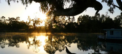
Murray River near Albury-Wodonga

Wodonga
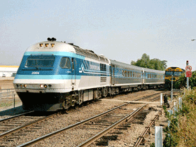
XPT train passing through Wodonga

Hume Dam and Reservoir

Gourmet foods at Milawa

|
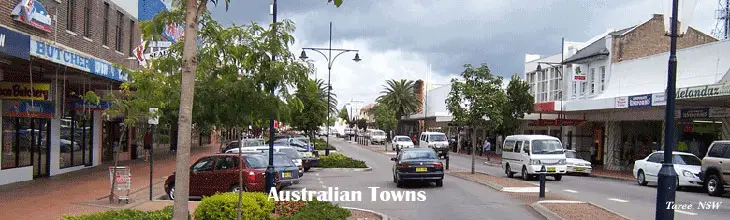
Albury-Wodonga is a broad settlement incorporating the twin Australian cities of Albury and Wodonga, built around where the Hume Highway cross the Murray River.
Where is it?: Albury and Wodonga are separated geographically by the Murray River and politically by a state border: Albury on the north of the river is part of New South Wales while Wodonga on the south bank is in Victoria. Whilst in many senses the centre operates as one community, it has parallel municipal governments and state government services. on the north bank of the Murray River, Albury is 596 km south west of Sydney and 307 km north east of Melbourne. The intercity XPT passenger train between Melbourne and Sydney passes through Albury station twice daily in each direction.
Index: Albury | Wodonga
Things to see and do:
With Australia’s longest river running through the heart of Albury Wodonga, you would expect to find idyllic river walks and parks. What you might not expect is a pub inspired by a cartoonist, an army museum with a huge collection of military memorabilia and a former migrant reception centre which helped change the face of Australia.
Albury Regional Art Centre is situated within a splendid, ornate and virtually unaltered Edwardian town hall (1907) with cupolas and extravagant stucco. It has an impressive collection of works by one-time resident Sir Russell Drysdale and is open daily (02 6023 8187). Next to the new Town Hall is a hall from the original 1860 house of assembly.
The P.S. Cumberoona, a replica of an 1886 paddle steamer which once used to visit Albury, offers one-hour tours of the Murray every day in season (02 6041 5558). Near its mooring point in Noreuil Park a reproduction Cobb & Co. coach.
Lookouts: Monument Hill is 90 metres above the city of Albury. The view stretches up and down the river and across the city. Huon Hill hase superb 360 degree views of Albury-Wodonga, Lake Hume and the snowfields.
Surrounding area:
One of the state border's most defining features is undoubtedly Lake Hume, keeper of water for irrigation and haven for recreational boaters, skiers, swimmers and anglers. A walk along the Hume dam wall is a must do whilst in Albury-Wodonga. The wall features a walkway along the top that is safe for children to ride bikes along, offering outstanding views of Lake Hume.
Wodonga is the northern gateway to Victoria's High Country. A drive through the pretty Kiewa Valley to the south of Wodonga marks the beginning of the Great Alpine Road, Australia’s highest year-round accessible sealed road that winds past lofty mountains, valleys, forests, rivers, vineyards and farms. More >>
Hume Weir Trout Farm has thousands of rainbow trout from fingerlings to adults which can be hand-fed or fished. Fish food, bait and rids are supplied. There are waterfalls, landscaped gardens and a kiosk. It is open daily from 9-5 (02-6026 4334).
Lovers of walking can truly get their fill on the Hume and Hovell Walking Track which follows the explorers' path from Albury to Gunning, 370 km north-east. It is a 22-day trek but it is possible to opt for half or whole-day and weekend walks. More >>
North East Victoria Gourmet region is the state's premier region for wine-lovers and foodies. Nestled between the high country's snowfields and the Murray River, this dramatic landscape of mountains, valleys, clean air and clean rivers, is the perfect backdrop for an inspirational food and wine experience. From the wineries of Rutherglen, Milawa, Glenrowan and the King Valley to the canned fruit outlets of Shepparton and all the specialist produce in between, the region is a gourmet lovers' delight. More >>
Albury-Wodonga was selected as the primary focus of the Whitlam government's scheme of the early 1970s to arrest the uncontrolled growth of Australia's large coastal cities (Sydney and Melbourne in particular) by encouraging decentralisation. Grand plans were made to turn Albury-Wodonga into a major inland city. Some industries were enticed to move there, and a certain amount of population movement resulted. However, the current population is much less than half the 300,000 projected by the Whitlam Government in the 1970s. The industrial employment sector has meant that Albury-Wodonga, unusually for an Australian inland city, is not dependent on agriculture.
Albury
Albury is located on the Hume Highway on the Northern and opposite side of the Murray River to its twin city, Wodonga. Albury has a population of 47,694 (2006); together the two cities form an urban area with a population of 82,974. Albury is approximately 550 km from the state capital Sydney, but only 312 km from the Victorian capital Melbourne. It is 147 km from Wagga Wagga, 16 km from Table Top and 4 km from Wodonga. The city is built above the river flats of the Murray River, and is 164 metres above sea level (539 feet) at the airport.
Albury serves as an administrative centre for the agricultural communities around the area, and the city is the home of a large newsprint paper mill which processes the pine logs planted in the mountains to the east, an engineering plant which produces automatic transmissions for cars, a major processing centre of the Australian Taxation Office, and other smaller secondary industries. Other large employers are: The Commercial Club, Albury Wodonga Development Corporation and Hume Building Society.
Transport: Situated just off the Hume Highway, the main Melbourne-Sydney highway, Albury remains a major transit point of interstate commerce. Albury railway station is on the main Sydney-Melbourne railway line. Originally New South Wales and Victoria had different railway gauges, which meant that all travellers in either direction had to change trains at Albury. To accommodate this, a very long railway platform was needed; the covered platform is one of the longest in Australia. The station is served by V/Line trains from Melbourne as well as Countrylink XPT services which run twice daily.
In 1873 the broad gauge (5ft 3ins) railway line from Melbourne reached the township of Belvior/Wodonga. In 1881 the New South Wales standard gauge 4 ft. 81?2ins) railway line reached Albury, with a railway bridge joining the two colonies in 1883. Albury was the stopover, where passengers on the Melbourne-Sydney journey changed trains until 1962, when a standard gauge was opened between the two capitals. The break of railway gauge at Albury was a major impediment to Australia's war effort and infrastructure during World Wars I & II; for every soldier, every round of munitions, tins of food, mail, and animals was off-loaded from the broad gauge and reloaded onto a standard gauge railway wagon. This massive Victoria/NSW bottleneck was one of several that existed throughout Australia.
The local airport has scheduled daily flights to Sydney and Melbourne through two carriers, QantasLink and Regional Express, in addition to charter services.
History: There are only few reminders of the indigenous population of the area, although the Wiradjuri people had occupied the area for many thousands of years. Little history is documented about the relationship of Aboriginal people and the European settlers.
The explorers Hume and Hovell arrived at what is now known as the Murray river at Albury on 16th November 1824 what their maps named 'Crossing Point'. They named the river the Hume River and inscribed a tree by the riverbank on the 17th before continuing their journey south to Westernport. A crossing place for the Murray became popular close to where Hovell inscribed the tree. In summer it was usually possible to cross the river by foot. An easier crossing was 10 miles upstream where the Hume Weir now is, however, the drovers' tracks led to Albury. A log punt was built in 1844.
Among the first squatters to follow in the steps of the explorers and settle in the district were William Wyse and Charles Ebden. The first European buildings erected at the crossing place were a provisions store and small huts. A survey for a town was commissioned in 1838. Assistant Surveyor Thomas Townsend mapped out Wodonga Place (the present Wodonga Place) as the western boundary, Hume Street as the northern boundary, Kiewa Street to the east and Nurigong to the south, with Townsend Street being the only other north-south road, and Ebden and Hovell Streets being the other two east-west roads. On early maps, the settlement was named Bungambrewatha.
The Government gazette of April 13, 1839 states: Albury, County unnamed on the east bank of the Murray at a place called by the natives Bungambrewatha. The reason for the name change from Bungambrewatha to Albury is not documented.
By 1847, the Albury settlement included two public houses and a handful of huts, a police barracks and blacksmiths. A log punt established in 1844 serviced the crossing of the Murray River. In 1851 with the separation of Victoria from New South Wales and the border falling on the Murray River, Albury found itself a frontier town. With increase in commerce with Melbourne, the first bridge was built in 1860. Albury at this time became a customs post between the two colonies as New South Wales held a protectionist stance on gaining its constitution in 1856. Albury was at this time starting to grow substantially with Germans using the area to grow grapes for wine, and escaping the growing nationalism in Germany. Albury boasted by the 1870s a butter factory, flour mill, wineries and locally brewed cider.
In 1888 Albury built its first school house. The city's first mayor James Fallon was an innovator of the Public School, funding a demonstration High School to be built on Kiewa Street.
The growing prosperity of Albury from the 1850s can be seen in the impressive Victorian civic buildings on Dean St between Kiewa and Olive Sts. The Classical Revival courthouse (1860) is one of the few remaining buildings designed by colonial architect Alexander Dawson. The large and imposing two-storey post office (1875) features arch work buttressed by a colonnade and a clock tower with cupola and weather vane which was added in the 1920s. The largely unaltered Classical building that houses the technical college was formerly the telegraph office (1885). The CML building has a five-storey clock tower with curved copper roof. The ANZ Bank (c.1915) is a large Edwardian bank with terracotta tiled roof. By contrast, the T & G Building, dating from the mid-1930s, features a far more modern design, the highlight being a five-storey tower with extremely long, thin vertical window recesses and a ziggurat summit.
Politics: Albury has a long standing connection to conservative politics. Following the first convention in Canberra to form the Liberal Party of Australia, delegates, including Sir Robert Menzies, met for a second conference in Albury at the Mates Department Store between 14th and 16th December 1944. The delegates agreed on the structure of the party organisation, adopted a provisional constitution and appointed a federal executive until one could be formally elected.
In 2003, a sister city relationship with Nanping in northwestern Fijian province, People's Republic of China, was formalised.
Wodonga
Wodonga, the twin of Albury, is a small city on the Victorian side of the border with New South Wales, 300 kilometres north-east of Melbourne, Australia. It is covered by the municipality Wodonga City Council. Its population is approximately 37,500 people, and with Albury forms an urban area with greater than 80,000 people.
Founded as a customs post with its twin city Albury on the other side of the Murray River, it has been regarded as the smaller, less prosperous cousin of the two (once commonly referred to by locals as 'Struggle Town'). Whilst still somewhat smaller than Albury, economic growth in both areas has ameliorated such distinctions.
Major secondary industries based in Wodonga include 'LOGIC' a logistics distributions hub, a large cattle market, a pet food factory (Master Foods), a cardboard box factory and an abattoir, as well as a variety of other, smaller enterprises. It also serves as a central point for the delivery of government services to the surrounding region. Wodonga houses the Asian corporate headquarters for Mars Corp. (locally known as Uncle Bens and more recently Masterfoods).
Wodonga is the site of an Australian Army logistics base and a training centre for army technical apprentices, Latchford Barracks. It is also the home of a campus of La Trobe University and Wodonga Institute of TAFE.
Wodonga railway station lies on the Melbourne-Albury and Melbourne-Sydney lines. There are future plans for the station to be moved from its present central location to a position on a new line on the northern edge of the town. Wodonga is on the junction of the Hume Highway (the main route from Melbourne to Sydney) and the Murray Valley Highway (which follows the southern bank of the Murray River). Local public transport is provided by Mylon Motorways, which run buses on a number of routes both within Wodonga and to Albury. Bus services are generally quite infrequent and public transport use in Wodonga is very low. There are also long-distance bus services to the capitals.
The World's Biggest Rolling Pin (listed in the Guinness Book of World Records) is located in Wodonga, atop "Henri's Bakery". When the bakery is baking fresh bread, you will find the rolling pin rotating!
Wodonga is also home to the Flying Fruit Fly Circus School, the educational arm of the Flying Fruit Fly Circus, that provides educational services with an emphasis on the performing arts and contemporary circus training. In 2003, a devastating fire[14] destroyed the school's facilities at then Wodonga High School, and the school relocated to Wodonga West Secondary College (now Wodonga Middle Years College Felltimber Campus).
View Larger Map
|