|
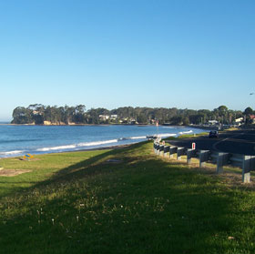
Batehaven beach
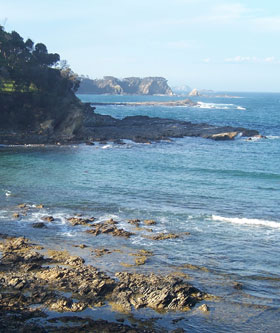
Malua Bay
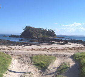
Berlings Beach, Tomakin

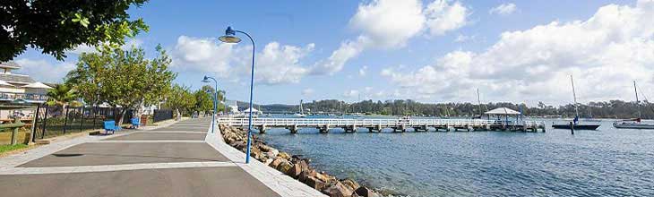
Clyde River
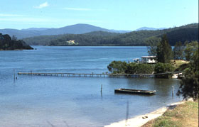
Clyde River
![]()
Mackenzies Beach

Pebbly Beach, Murramarang National Park
 St Patricks church, Araluen St Patricks church, Araluen

Pigeon House Mountain and the Byangee Range, The Budawangs

Monolith Valley, The Bundwangs
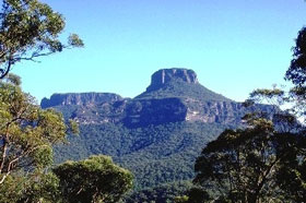
Pigeon House Mountain
|
Batemans Bay is a laid back holiday centre on the New South Wales south coast. It is the closest seaside town to the city of Canberra, making the town a popular weekend and holiday destination for residents of Australia's National Capital. A popular retiree haven, Batemans Bay has begun to attract young families seeking affordable housing and a relaxed seaside lifestyle.
Where is it?: New South Wales: South Coast. Batemans Bay is located on the Princes Highway about 280 kilometres from Sydney, 760 km from Melbourne and 151 km from Canberra via the Kings Highway.
Lookouts: some favourite spots to take in the local landscape are: Holme’s Rotary Lookout, Round Hill Fire Tower Lookout, Observation Head, Big Bit Lookout and Folder’s Hill Lookout.
Things to see and do:
The Eurobodalla Regional Botanic Gardens abounds with a wide variety of flora and fauna; the original flora of the area includes many of the 2000 species found within the Collecting Region, and the fauna consists of kangaroos, wallabies, bandicoots, possums, echidnas, snakes, lizards, frogs and many bird species. Display gardens, walking tracks, picnic and barbeque facilities, an herbarium, information centre and café are some of the features to be found in the Gardens complex. More >>
Surrounding area:
The 22 km coast road from Batemans Bay to Broulee follows the shoreline for much of the way and is a particularly picturesque drive along one of the most eye pleasing stretches of the New South Wales coastline. There are many beautiful beaches along it, interspersed by headlands, many with small islands offshore.
The beaches around Batemans Bay are typically small and sheltered, cupped between headlands where the waves crash over splintered fingers of dark rocks. Pebbly Beach (12 km north) is the best known of all these beaches, as it is here that kangaroos not only graze on the grass above the beach and around the cabins, they often jump into the surf and splash around. Pebbly Beach is in Murramarang National Park.
Murramarang National Park protects over 11,977 hectares of coastal land between Kiola and Batemans Bay. The park's largely undisturbed coastline with its sandy and shingle beaches, rugged headlands, tombolas, rock stacks and fossil-bearing rocks provides visitors with a rich environment to explore. More >>
Though access is difficult, the park being bounded by private property and permission must be obtained from landowners adjoining to gain entry, Budawang National Park is wild, angular sandstone country. Hidden valleys hold rainforests, heaths fill with wildflowers in spring. There is a rugged wilderness area, including the Budawang Range and the eastern escarpment of the Southern Tablelands, which is a popular spot for experienced bushwalkers. Its grand features as Shrouded Gods Mountain, the Byangee Walls, The Castle and more. More >>
Araluen (86km north west) is an old mining town, nestled in the Araluen valley in the heart of the Southern Tablelands. Today it is little more than a few buildings in a beautiful valley noted for its orchards. There is still some gold about, and plenty of reminders of the town's heyday, such as the local cemetery and mining relics scattered around the old diggings. The road to Batemans Bay through Moruya is mostly a dirt road which is quite accessible although it is probably quicker to travel through Braidwood via the Kings Highway (86km each way), which is a pleasant drive anyway. More >>
Situated within the Morton National Park, approx. 75 km north of Batemans Bay, Pigeon House Mountain is part of Australia's eastern mountainous escarpment which separates the coastal plain from the interior tableland. Pigeon House rises steeply to 720m above sea level and you can climb safely to the summit. However it is not just a leisurely tourist jaunt. A day trip is for the reasonably fit, adventurous traveller who is looking for a day of testing, but not arduous exercise, rewarded by a spectacular 360 degree vista that lays at your feet the beaches and Pacific Ocean to the east and the magnificence of the Budawang Mountains and the Clyde River Valley to the west. More >>
About Batemans Bay
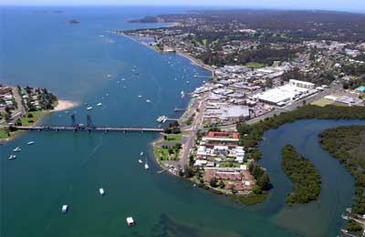
Situated where the Clyde River empties into the Pacific Ocean, Batemans Bay has a population of around 11,000 but this almost doubles with the influx of holidaymakers during school holiday times. To the south of Batemans Bay are the residential localities of Catalina, Batehaven, Sunshine Bay, Denhams Beach, Surf Beach, Lilli Pilli, Malua Bay, Rosedale, Mossy Point and Broulee.

Guerilla Bay from Burrewarra Point
Climate: the climate of Bateman's Bay is moderated by the sea, with warm summers and mild sunny winters. Nights can be cold in winter. Thunderstorms can occur between November and March, with rainfall maximums in summer. Nonetheless its is a place that can be visited all year round.
History: Lieut. James Cook named Pidgeon House Mountain and Batemans Bay on 21/22 April 1770 after Nathaniel Bateman. Nathaniel Bateman was Captain of Lord Colvill's ship HMS Northumberland, when Captain Cook was serving as her master from 1760-62.
Indigenous Australians in the area attacked the crew of the ship the Fly, a colonial vessel, in 1808 after it was driven into Bateman's Bay by bad weather.
In 1821 Robert Johnson entered the bay and explored the lower reaches of the Clyde River on board the cutter Snapper. Snapper Island within the bay is named after Johnson's boat. Johnson returned with Alexander Berry and Hamilton Hume and they traced the river to its source.
When the district was surveyed in 1828, a deserted hut and stockyards were found. Cedar getters and land clearers were in the district in the 1820s. From the 1820s through to the 1840s, the area to the Moruya River was the southernmost official limit of location for the colony of New South Wales.
The village of Batemans Bay was surveyed in 1859. Oyster farming commenced in 1860. By 1870, there was a fleet of 40 oyster boats. A sawmill was erected in 1870. The port was proclaimed in 1885. A ferry service across the Clyde ran from 1891 until the bridge was opened in 1956. In 1942 during World War II, a trawler was attacked by a Japanese submarine between Batemans Bay and Moruya.
View Larger Map
|