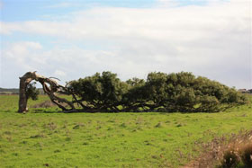
Tree at Greenough
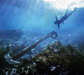
Diving on a shipwreck in the Abrolhos Islands

HMAS Sydney Memorial, Geraldton
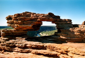
Nature's Window, Kalbarri National Park
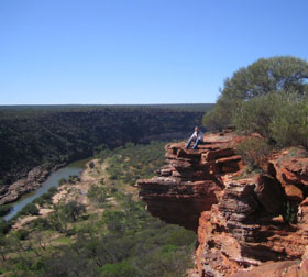
Kalbarri National Park
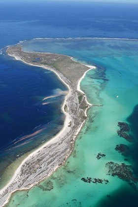
Abrolhos Islands
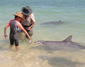
Feeding dolphins, Monkey Mia, Shark Bay
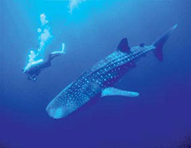
Swimming with a whale shark on Ningaloo Reef
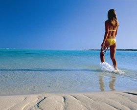
Ningaloo Reef beach
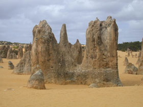
The Pinnacles, Nambung National Park
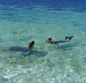
Swimming with a seal in the Abrolhos Islands
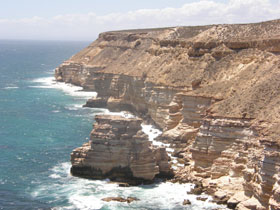
Castle Rock, Kalbarri coastline
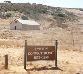
Lynton convict settlement
![]()
Mt. Augustus
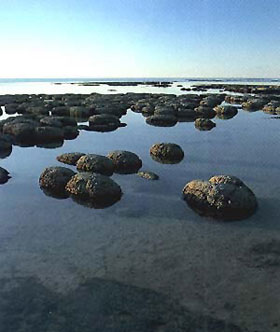
Stromatolites at Hamelin Pool, Shark Bay
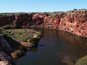
Yardie Creek near Exmouth

Mandu Mandu gorge near Exmouth
Charles Knife Canyon, North West Cape

Harold E. Holt Naval Communications Base, Exmouth
|
The Coral Coast and its hinterland forms a vast area of contrasts. It is here where the desert literally meets the ocean, creating fascinating landscapes. The area is noted for its beautiful coastal stretches, fields of native wildflowers, rugged open spaces, abundance of wildlife and pleasant, small coastal towns. It is lesser known for the many significant events in Australia's history that were played out on its shores.
Ningaloo Reef
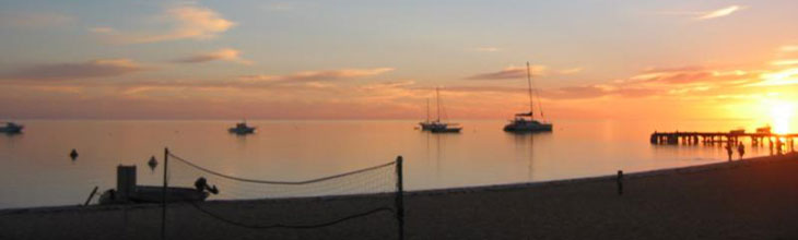
Covering approximately 1270 kms of Western Australia's coastline, it stretches from Cervantes, north of Perth, to Exmouth on the north-west corner of Australia. Here you can swim with the world’s largest fish - the whale shark, snorkel from the beach to the stunning Ningaloo Reef, meet the dolphins of Monkey Mia and take in the unique rock formations of the Pinnacles.
Muchea: A small town 57 km north of Perth, Muchea had its 5 minutes of fame in the early 1960s when the Muchea Tracking Station was established about 4 km outside of town as part of NASA's Mercury project. In 1962, the first Australian to speak with a space traveller did so from the Muchea facility.
Leeman: a fishing village 292 km north of Perth on what is now known as the Coolimba Coast. It is thus named after the original white settlement in the area to the north of Leeman. In March 1658, as first officer and navigator of the Waeckende Boey searching for the wreck of the Dutch ship Vergulde Draeck, Abraham Leeman van Santwits led a party ashore off Lancelin Isld. Leeman and his crew were caught in the storm and found themselves stranded on a strange land. Leeman refused to accept the impossibility of his situation and, after killing a number of seals and doing his best to collect adequate provisions, he and his party of 14 men set sail for Batavia in an overloaded open boat. He and three sailors survived the epic journey. A plaque on a limestone obelisk at the end of Marcon Street, Two Rocks (to the south), marks the place where Leeman and his men came ashore.
Dongara: 3 1/2 hours north of Perth by car lies Western Australia's Mid West region. This area offers a relaxed lifestyle with beautiful beaches, historical sites and a healthy fishing industry based at the twin towns of Dongara and Port Denison. Originally built on a strong rural economy, Dongara and Port Denison now have a thriving rock lobster fishing and processing industry and is ever-increasing in popularity as a place for tourists. To the north of Dongara is the abandoned hamlet of Greenough, which has been preserved as a window into life in 19th century rural Western Australia.
Geraldton: 500km north of Perth, Geraldton is Western Australia's second largest seaport after Fremantle, and the administrative centre for the state's mid-west region. On the Champion Bay, Geraldton is surrounded by sandy white beaches with good fishing. It has the double advantage of being the seaside resort for the wheat farmers from the dry hinterland and, with an average of 8 hours sunshine every day, even in winter, being Western Australia's most popular winter resort. Equally, while small townships like Cervantes, Jurien and Port Gregory have lobster fleets, Geraldton has the largest lobster fleet on the west coast. The surrounding area is rich agricultural land, and the district is noted for its beautiful spring wildflowers and picturesque countryside. Geraldton and Kalbarri form part of the coastal area of the Mid West region also known as the Batavia Coast, named after the Dutch trading vessel Batavia that ran aground on a treacherous reefs in the Abolhos Islands group in 1629. Some of the survivors attempted a bloodthirsty mutiny when a vessel came to rescue them. Geraldton Maritime Museum houses a popular Shipwrecks Gallery, which tells the stories of the many Dutch shipwrecks off the coast between 1629 and 1727, including the Batavia mutiny.

Hutt River Principality: North of Geraldton, on the road to Kalbarri, is Hutt River Principality, a large farming property that has become somewhat of a tourist attraction. Australia's oldest micro-nation, it has claimed to be an independent sovereign state since its foundation in April 1970 when it seceded from the state of Western Australia, but has never been formally acknowledged by the Commonwealth of Australia or any other international entity. The province was created in response to a dispute with the Western Australian government over what the wheat-farming Casley family saw as draconian wheat quotas. Led by Prince Leonard I (Leonard George Casley), Hutt River Principality has its own stamps and currency and issues its own passports. Although actual residents are very few (around 20), the principality claims a world-wide citizenry of 13,000. Some Australians view Prince Leonard affectionately as a harmless eccentric and view his tenacity in taking on "big government" with wry amusement, while others believe him to be looking for a fight where none exists. He is the subject of a permanent exhibit at the National Museum of Australia, in Canberra, an exhibit that acknowledges that the Principality of Hutt River has successfully seceded from the Commonwealth of Australia.
Abrolhos Islands: The Abrolhos Islands, which lie 64km off the coast, are surrounded by reefs and shipwrecks. The islands are a bird-watchers paradise and are also the centre of the area's lobster-fishing industry. The Abrolhos islands were first sighted and reported by Frederick Houtman in 1619 who warned of the dangers of the area, particularly as the maps were inaccurate. A decade later the reefs claimed their first known victim, the Batavia. When the Batavia struck Morning reef in 1629 it was carrying 316 people as well as jewels and 12 chests of silver coin worth 250 000 guilders and building materials for Batavia (now modern day Jakarta) in the Dutch East Indies. Of the survivors Captain Francisco Pelsaert took the ship's boat and with 47 of the survivors sailed up the coast to Batavia (a remarkable feat) while Jeronimus Cornelisz terrorised the survivors, eventually murdering 125 of them.
Kalbarri: as recently as 1943, there were only a few crayfishermen living in the area and the township, if it could be called that, was known simply as 'The Mouth of the Murchison'. Today the town is a popular tourist destination with fishing, swimming, horse riding, bushwalking, a wildflower park called Kalflora, a Fantasyland Museum with a display of dolls and marine artifacts, an amusement centre, the Rainbow Jungle bird park, canoe safaris, ocean fishing, joy flights and river cruises.
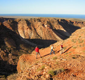
Kalbarri National Park is generally considered one of the best National Parks in Australia in terms of ease of access and variety of natural attractions. The elaborate and spectacular twists and turns of the Murchison River as it cuts its way to the sea through picturesque, spectacular gorges, the dramatic beauty of Red Bluff, and the equally dramatic beauty of the sandstone cliffs to the south of Kalbarri township make it a National Park rich in variety, drama and beauty. Between August and October, it becomes a vast carpet of wildflowers.
Shark Bay: a place of stark seascapes, islands, bays and bays that are habitat for a range of plants and animals found in the wild nowhere else on Earth. A World Heritage Area, Shark Bay has a coastline more than 1,500 km long. Its vast shallow bay is broken into a series of gulfs, inlets and basins by north-trending dune ridges and seagrass banks. Red wind blown sand dunes, soaring limestone cliffs, birridas and white beaches are features of Shark Bay's stark, ancient and varied landscape. The bays, inlets and islands of Shark Bay support a profusion of aquatic life. Turtles, whales, prawns, scallops, sea snakes, fish and sharks are common.
One of only two places in the world with living marine Stromatolites, or "living fossils", Hamelin Pool also has the distinction of being Western Australia's only marine nature reserve. The Stromatolites are one of the most important features of the Shark Bay World Heritage area. They look like rocky lumps strewn around the beach but are actually built by living organisms too small for the human eye to see. The most westerly point on the Australian mainland - Steel Point - is accessed from Useless Loop Road. Steep Point is renown for great fishing and unique scenery, and is an excellent spot for four-wheel driving, photography and bush camping.
The small township of Denham is both the western most town in Australia and the only town in the Shark Bay area. It is also gateway to Monkey Mia with its famous friendly dolphins. Denham is located on the western coast of the Peron Peninsula on Shark Bay, some 23 km southwest of the dolphins and 831 km north of Perth.
Monkey Mia: In the 1960s, fishermen began feeding bottlenose dolphins in the Shark Bay area, which in time began appearing regularly when they returned with their catch. Over the years, the association continued. News of the phenomenon travelled by word of mouth and visitors now come from far and wide to see the dolphins. These dolphins are wild animals that come to the beach of their own free will to interact with people and accept fish from them. Seven or eight dolphins are now regular visitors and the habit has been passed from mother to young, so that the beach visitors now span three generations. They belong to a much larger local group that lives further out in the Bay.
Point Quobba blowholes
Carnarvon: 983km north of Perth, Carnarvon is the commercial centre of the highly productive Gascoyne region. The town's warm winters, hot summers and a tropical appearance, with bougainvilleas, hibiscus blooms and banana plantations, clearly announce to northern travellers that they have now entered Western Australia's tropical region. The town also is the centre of an area which grows avocados, coconuts, dates, jojoba, macadamia nuts, mangoes, pawpaws, pecans, tomatoes, pineapples, melons and various varieties of beans. It is widely recognised that the biggest event in recent Carnarvon history was the establishment of the NASA tracking station in 1964. Its greatest moment came on 20 July 1969 when Neil Armstrong stepped out of Apollo 11. His famous words 'One small step for man. One giant leap for mankind' were relayed to the world via the tracking station at Carnarvon. It was finally closed down in 1974 because it became outmoded.
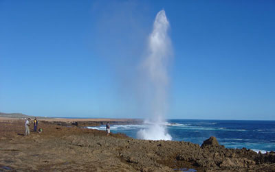
The Blowholes, Quobba, Lake Macleod and the wreck of the Korean Star, north of Carnarvon are some of the most interesting sights on the whole of the Western Australian coast. The coastline here is characterised by spectacularly beautiful craggy cliffs, beautiful white sandy beaches and a dramatic variety of seascapes.
Mt. Augustus: The world's largest monolith, Mt. Augustus, is situated in the outback of the Gascoyne region 320 km east of Carnarvon. More than twice the size of Uluru, it is almost 8 km long, it stands 858 m above the surrounding plain and 1105 metres above sea level. Mt. Augustus is surrounded by other fascinating geological formations, Aboriginal rock art and engravings plus a wealth of animal and bird life. The journey to Mount Augustus is far from easy (4-wheel drive only) but the result of the effort is a rare opportunity to see one of the wonders of Australia. The most significant difference between Uluru and Mount Augustus is that the former has a hard coating on its exterior which has, very distinctively, created a situation where there is no scree slope at the bottom of the monolith. In the case of Mount Augustus there is a scree slope so it lacks the distinctive shape of Uluru although it does change colour during the day. Mount Augustus also has considerable vegetation on its slopes.
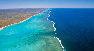
Ningaloo Reef: The Ningaloo Reef between Coral Bay and Exmouth is 260 kilometres of coral reef sheltering a shallow lagoon. The wonderful thing about Ningaloo, besides the excellent diving, snorkelling and coral viewing opportunities, is the fact that you walk straight off the beach and onto the reef. On this reef, the longest coastal reef in the world, see fish, whales, dugongs and turtles. From March through June each year the area is visited by migrating whale sharks and humpback whales. The townships of Coral Bay and Exmouth are the major base points for visiting the Ningaloo Reef.
Exmouth: a regional centre and home base for exploration of the Exmouth Gulf area, Exmouth is one of Australia's youngest towns. It came into being in 1963 when the Australian and United States governments agreed to establish the $66 million Harold E. Holt US Naval Communication Station at North West Cape. This single event created the town. From its earliest days it was always a military town, home to around 700 US and Australian personnel who worked on the base. The base was built to communicate over immense distances with submerged submarines in the Indian Ocean during the Cold War. The population of the town peaked at around 4300 in the late 1960s. In the overall web of facilities that make up the worldwide US intelligence gathering network, North West Cape, until recently, played an important and acutely sensitive role. It was never very far from the drama and controversy that pivoted around the fears of possible nuclear war between the superpowers.
Today, Exmouth's claim to fame is the fact that it is the closest mainland town to the continental shelf. This results in there being very rich fishing grounds within close reach. In addition, its colourful coral reefs are very close to the shore, and have become tourist attractions in their own right.
North West Cape: the peninsula which separates Exmouth Gulf from the Indian Ocean on the north west tip of the continent contains the rugged and waterless Cape Range and Rough Range. A locality full of contrasts, the traveller passes from high plateau shrub land to deep ocean, eucalypt woodlands to deep rocky gorges, within just a few kilometres. The scenery is quite breathtaking, from the flat coastal plain to the range's rocky canyons and terraces, coastal dunes, white sand beaches and turquoise water and rocky shores. Unsealed roads and tracks make 4-wheel driving a recommended part of the experience.
Mandu Mandu Gorge, Yardie Creek Gorge, Charles Knife Canyon and Shothole Canyon give totally different perspectives to the scenery in this rugged, isolated but extremely beautiful corner of the country. The Shothole Canyon road passes through the gorge, whereas the Charles Knife Canyon takes you up onto the top of a ridge between two canyons. In some places the gap between the canyons is only just wide enough for the road and both sides plunge precipitously down to the canyon floors which can be quite unnerving. Charles Knife is where the first test drills to find oil were made in Australia in the 1950s.
How to get there: Because of the vast distances between localities, and that many highlights can only be reached by road, serious consideration should be given to touring the area by motor vehicle, or as part of an organised tour, unless you only have the time or inclination to visit a single locality. In such cases, way up carefully the cost and time involved in going to just one locality. Many travellers who have done that feel it did not provide value for money and wished they had made alterative travel arrangements or not gone at all.
By air, Skywest Airlines operate a twice daily service between Perth and Exmouth, Carnarvon, Geraldton, Kalbarri and Shark Bay, and a weekly service (on Sundays) between Broome and Exmouth.
By road, travel north from Perth on Great Northern Highway, taking Brand Highway at Muchea. The Greyhound bus takes approximately twelve hours from Perth to Carnarvon and travels every day, some days twice, to localities throughout the region.
The best time to go: June to November are the best times to visit the localities in the north. December to April is cyclone season in the tropical regions and most rainfall occurs at these times. The area to the south of Kalbarri is not affected by cyclones to any great degree, so this region can be visited any time of the year. The summer months can be hot and flies can be a nuisance then, so March to May and August to November are our preference.
June is the season to swim with the Whale Sharks at Ningaloo Reef, as they migrate through these waters at that time. Humpback whales visit the the Coral and Shipwreck Coasts between June to November each year, migrating twice annually through the area into the Exmouth Gulf. The first visit occurs in late autumn (June-July) during their northern migration, and they return in their southern migration each spring (September-November).
Wildflowers occur throughout the Coral Coast region. July to November is wildflower season, with the best bloom around September to November.
|