|
![]()
![]()
View from the summit of Toolbrunup Peak
![]()
Castle Rock Bridge, Porongurup Range
![]()
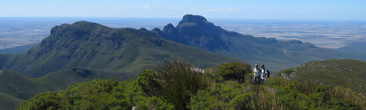
Trail to the summit of Bluff Knoll
![]()
Snow on the summit of Bluff knoll
![]()
Mt. Trio
![]()
Toolbrunup Peak
![]()
Talyuberlup Peak
|
The jagged peaks of the Stirling Range have become somewhat of a mecca for bushwalkers and rock climbers in the Great Southern region of Western Australia. These mountains stretch for 65 kilometres from east to west; all peaks offer excellent views and walkers can discover flowering plants at any time of year.
![]()
The Stirling Range and the neighbouring Porongurups Range are some 40km north of Albany and are both part of the Stirling Range National Park. The Park covers 2401ha of diverse land; the most striking feature is the mountain ranges. This chain of high, craggy peaks stands out against rolling hills and forest covered valleys running 65km east to west. The granite formations of the Stirling Range and Porongurups were formed 1100 million years ago.
Porongurup Range
The Porongurups are internationally recognized for the diverse wildlife they supports, many species are exclusive to this ancient area. They are home to vast forests of beautiful karri trees that require karri loam and a great deal of rainfall to grow.
The Porongurups boast a very moist climate on the high peaks as they reach up into the clouds and get plenty of rain-laden sea winds, staying moist and receiving plenty of rainfall. For this reason, the Porongurup Range is home to this one such ‘island’ of karri forest.
There are many walking trails that lead through the Porongurups, taking in the spectacular views of Devil's Slide, Marmabup Rock, Nancy and Hayward Peaks. Cross the range along the Wansborough Walk, or marvel at Balancing Rock.
More information
![]()
Porongurup Range
Apart from the thick bush land of karri, jarrah, marri and wandoo trees, the unique environment of the Porongurups support over 1500 varieties of plants, of which 90 are found nowhere else.
The town of Mount Barker with its mixed farming and ever-growing world-class wineries and vineyards (including the famous Goundrey Estate) is considered the gateway to the Porongurups.
Stirling Range: suggested bushwalks and mountain climbs
Bluff Knoll
Listed as one of Australia's 25 best hikes, Bluff Knoll is the highest peak in the Stirling Range and indeed the whole southwest of Western Australia. With 360° views at the summit it offers ocean glimpses on a clear day. It's a moderate climb to the top but well worth the effort.
6km return. 3-4 hours. Altitude 1094.97 metres or 656 metres from car park. More information
Toolbrunup Peak
Looking west from Bluff Knoll, Toolbrunup Peak towers above other mountains. With a summit half the size of a tennis court and magnificent 360° views, this mountain appeals to hikers wanting a "top of the world experience". The trail up the mountain is a wilderness track with loose scree encountered for the last 1/5 of the hike. Toolbrunup was burnt in January 1996, caused by lightning strike.
Walk: 4km return. 4 hours. Altitude 1052 metres
Ellen Peak
Located at the eastern end of the Stirling Ridge Walk. Apart from the first 5kms of firebreak the track is informal and unmarked and easy to lose. A compass traverse may be necessary. Very strong gusty winds and/or boisterous conditions sometimes occur at short notice. Please contact the Retreat office for information regarding access to Ellen Peak.
Walk: 22km return. 10-12 hours. Altitude 1012 metres
Stirling Ridge Walk
The only alpine walking in Western Australia, the Stirling Ridge Walk involves narrow ledges and very steep ascents and descents and much scrambling over jagged rocks and through sharp bush. Violent weather changes including very strong gusty winds, whiteout, sleet or snow can occur with little notice. It usually involves a two night bivouac which may be in these conditions, so walkers must be appropriately equipped. The trail is unmarked and easy to lose, and a compass course may be necessary.
Walk: 22km return. 10-12 hours. Altitude 1012 metres
Mt. Trio
Three separate peaks are linked together by a plateau was originally known as Warrungup. The steep walking trail with some scree beings at the carpark with a tourist boardwalk and continues up the plateau at the summit. Here during spring - on the summits - walkers will be rewarded with beautiful mountain bells and southern cross flowers. The mountain slopes are endowed with wildflowers from mid August to October.
Walk: 2km return. 3 hours. Altitude 856 metres
Mt. Magog
Burnt by wildfire (started by lightning) in January 1999, this trail commences from a lovely white gum/heath picnic area up through the valley towards the summit. The track is overgrown in some places.
Walk: 7km return. 6 hours. Altitude 856 metres
Mt. Hassel
This popular hike finishes with a short steep scramble over a dome of rock, forming the summit. This is an "easier" hike, with many wildflowers during spring.
Walk: 2km return. 2.5 hours. Altitude 847 metres
Talyuberlup Peak
A rock hopper's paradise, with interesting chasms, rocky spires and narrow gullies at the summit. Some scrambling over ledges is required.
Walk: 2km return. 2.5 hours. Altitude 783 metres
Wildflowers of the Stirling Range National Park
Wildflowers are profuse in September and October, the well camouflaged orchids bloom from mid August to early. From November to January high country walkers find the higher the altitude the more flowers they will discover. From April, enjoy autumn bush walking which can be magic. In winter, (mid May to mid August) when strong southerly wind and widespread frost occurs, there is an increased likelihood of snow on top of the highest peaks. When snow is forecast, weather conditions on the mountain tops are extreme.
|