Australia's Ghost Towns
Just about every 19th century ghost town in Australia burst into life and faded into oblivion just as quickly as a result of mining, particularly gold mining. Some gold mining towns with a short productive life declined significantly in the decades after the gold rush as other towns in the district continued to grow. The small township of Creswick, just north of Ballarat, for example, had a population of 25,000 during the peak of its gold rush. Like Clunes, further north, it was a huge mining community now reduced to around one tenth of its size. Heathcote, the centre of the McIvor diggings in Victoria, had sprung up as a mining village of 30,000 diggers in 1852 and was deserted a decade later. With only a few buildings still standing, the ghost towns of Home Rule and Gulgong, near Mudgee in New South Wales, are only shadows of their former brief glory in the roaring days of the 1860s and 70s.
Perhaps the greatest example of calamity to befall a once great mining centre is the town of Coolgardie in Western Australia, where vast quantities of gold were discovered and largely exhausted for the individual prospector in a short time. The remoteness of the region did little to encourage continued growth, despite the arrival of the railway line in 1896. Coolgardie sparked the greatest gold rush in Australian history and grew rapidly from the first discovery of gold in 1863 to become the third largest town in the state after Perth and Fremantle. By the turn of the century water was being piped to the city. However, mining operations were already moving to nearby Kalgoorlie, where the gold deposits were much larger.
The town, which had a peak population of around 15,000, had ceased to be a municipality by 1921. The population fell dramatically and, at one point, had declined to less than 200 people before a brief revival in gold prices during the 1980s. Coolgardie's main promenade, wide enough to allow long camel trains to turn around, with its elaborate 19th century hotels and office blocks, is like so many ghost towns scattered around the country - standing at odds with its present status, and is both a reflection of not only the great riches and but also the impermanence of the gold rush era.
 |
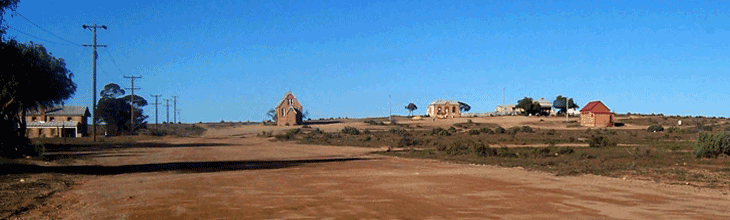
Araluen (NSW)
Araluen is one of the most famous gold towns in New South Wales. Located in the heart of the Southern Tablelands, today it is little more than a few buildings in a beautiful valley noted for its orchards. The goldrushes of the late 1840s disrupted the established cattle grazing in the area with labourers rushing to the Bathurst area hoping to find their fortune.
Location: 318 km from Sydney via Goulburn and 364 km via the Princes Highway. | Araluen and surrounding village |
 |
Tambaroora and Hill End (NSW)
The historic village of Hill End and the surrounding territory has a history as rich as the gold that was found there well over one hundred years ago. Alluvial gold was discovered at Hill End in 1851, and there were 150 miners on the site within a month. Today, Hill End is a fascinating historic site run by NSW National Parks, a picture perfect goldmining ghost town, with museums, cafes, craft shops and hotels which create a real feeling of stepping back in time.
Location: 275km north-west of Sydney; from Bathurst either travel through Sofala (approx. 80 km), Turondale (approx. 70 km) or follow the scenic route which follows the Macquarie and Turon Rivers called The Bridle Track (approx. 60 km). Hill End visitor information | Tambaroora visitor information | History Hill
|
 |
Sofala (NSW)
Nestling in the lovely hills of the Turon River valley is Sofala, the oldest gold town in Australia. Settled only three weeks after the first official gold strike at Ophir, Sofala swelled to a peak population 40 000. Today it has contracted to a totally captivating, rustic village of around 100 people. The surrounding district is primarily superfine wool farms. Each farm has many relics and remnants of the goldrush.
Location: 241 km north-west of Sydney; 60 km north from Bathurst via Wattle Flat. | visitor information
|
 |
Mount Hope (NSW)
Situated between Cobar and Hillston in Outback NSW, Mount Hope is one of Australia's copper mining ghost towns, with a population of 11, the hotel being the main focal point for the town. First licensed in 1881, Mount Hope Pub offers travellers a refreshing break from driving along the newly created tourist route, The Kidman Way.
Location: 610 km west of Sydney via Lithgow, Orange, Forbes, Condobolin and Euabalong. | visitor information |
 |
Silverton (NSW)
Situated 25km north-west of Broken Hill, this once thriving community of over 3000 is now a picturesque ghost town. The gaol, which closed in 1943 has been restored as a museum and houses many interesting relics from the past. Resolutely defying the stark desert landscape that threatens to swallow it, Silverton is a popular place for film-makers, having been the location for Mad Max 2, A Town Like Alice and Razorback.
Location: 25 kilometres north west of Broken Hill in far western NSW. | visitor information
|
 |
Yerranderie (NSW)
Yerranderie was a silver and lead mining town from late in the 19th Century to about 1950 but is now a privately owned ghost town with a fascinating story of considerable heritage significance interest to visitors. Set in a remote section of the foothills of the Blue Mountains, its old mine sites can be fossicked and explored freely, there are lovely walks and swimming holes and kangaroos, emus, lace monitors and even wombats will surround you. 4WD may be necessary to reach Yerranderie.
Location: 100 km west of Sydney via Oberon, on a dirt road (an old stock route) marked 'Mt. Werong' and 'Jerrong'. | visitor information
|
 |
Kiandra (NSW)
Built on the wave of a goldrush in 1860, the town of Kiandra was once home to thousands of people and survived for 100 years, but is today better known as the birthplace of Australian skiing. Gold was discovered in a creekbed in 1859, and soon 15 hotels and 30 stores stood ready for the rush, which lived up to all expectations. The area is rich in pioneer history, with relics such as the water races built by the miners and the old cemetery. A self guided heritage walk includes signs on the sites of many of the main buildings to give visitors a sense of Kiandra as it was.
Location: 85kms north-west of Cooma on the scenic Snowy Mountains Highway. | visitor information | Kiandra Historical Society
|
 |
Joadja (NSW)
In an isolated valley, the remains of the historic mining village of Joadja can be seen. These include including the miner's cottages, a schoolhouse, a church, a cemetery and shale ovens for the refinement of kerosene, which have a World Heritage listing. Edward Carter began mining shale there in 1874; it was excavated and heated in brick retorts to draw off the kerosene, which was then condensed and purified. The Australian Kerosene Oil and Mineral Company built a refinery, a railway line to Mittagong (which operated from 1880 to 1903) and erected the town for its employees. Operations ceased in 1903.
Location: 31 km north-west of Mittagong in the NSW Southern Highlands | visitor information
|
 |
Kanowna (WA)
One of Australia's most remarkable ghost towns, after the discovery of gold in the area in 1893, the population rose to over 12,000 by 1905. There were 16 hotels, two breweries and an hourly train service to Kalgoorlie. However, the alluvial gold supply was rapidly exhausted, and underground mining followed, yeilding decreasing amounts of gold, resulting in a slow but steady decrease in the population. By 1953 the town had been completely abandoned. There is nothing but rubble and two cemeteries left of the original town.
Location: 19 km north east of Kalgoorlie-Boulder in the WA Eastern Goldfields | visitor information
|
 |
Kookynie (WA)
This small town has declined from 1,500 to fewer than 10 people, but the 1894 vintage Grand Hotel survives, with its big verandahs and spacious rooms. The town is surrounded by old mine workings and tail dumpings. Of special interest is the Kookynie Museum, open daily, with its collection of photographs, memorabilia and antique bottles that tell the story of the town.
Location: 70km north east of Menzies in WA's Murchison Goldfields. | visitor information
|
 |
Niagara (WA)
Just 10km from Kookynie, Niagara also went from boom to bust The population in 1905 was 1,000 and is now nil. Almost nothing remains of the buildings, but visitors may find many old bottles and small relics of the gold rush days. Niagara Dam was built in 1897 with cement carried from Coolgardie by camel-back. This oasis in the wilderness provides a picnic, swimming and camping spot. Road access is not suitable for caravans.
Location: south east of Leonora in WA's Eastern Goldfields. Area map
|
 |
Big Bell (WA)
An abandoned gold mining town with few of the old buildings still remaining, the most prominent being the Big Bell Hotel. The hotel reputedly had the longest bar in Australia. Big Bell was once a railway branch terminus in Western Australia's Murchison Region. In 1902 Herbert Hoover, the 31st President of the United States, was a mining engineer and manager at the Big Bell open cut gold mine. Mining ceased in 2003 and the plant was deconstructed and transported to the Westonia minesite in 2007.
Location: near Cue in the Murchison Goldfields
More information
|
 |
Day Dawn (WA)
Day Dawn was home to over 3,000 goldminers and their families in the early 1900s. Its rapid growth and prosperity was due largely to the Great Fingall mine (left), once one of the richest and most profitable gold-mining operations in Australia. The success of the Great Fingall was closely associated with Herbert Hoover. Hoover is primarily credited with making them profitable for tens of thousands of shareholders worldwide.
Location: a few kms south-west of Cue in the Murchison Goldfields | visitor information
|
|
Ora Banda (WA)
Ora Banda (the name is Spanish meaning 'band of gold) is now a virtual ghost town, though it can claim a longevity which most of the other so called 'ghost towns' on the goldfields have never enjoyed. Gold was discovered in there in 1893 and shortly afterwards the Weston brothers established the Ora Banda mine. The mine continued to operate until the late 1970s though it was forced to stop operations during World War I because of the lack of water.
Location: 663 km east of Perth, 70 kms north of Kalgoorlie in the WA Eastern Goldfields | visitor information
|
 |
Wittenoom (WA)
The town's location close to the popular Karijini National Park has meant that for many years it was the service town for tourists visiting some of the spectacular gorges in the area. However, Wittenoom is better known for its association with the mining of blue asbestos (crocidolite). Large-scale mining began around 1943. The town was established in 1946 to house the workforce of the Wittenoom Gorge mine and mill 10 km away. There were horrendous dust levels recorded in the mines and mill and the diseases (asbestosis, lung cancer and mesothelioma) caused by this exposure have been well recorded and publicised in recent years. The last operating mine closed in 1966 for economic reasons and the town began its decline. For health reasons, the town no longer officially exists, however a few buildings remain.
Location: 1,400 km north of Perth in WA's Pilbara region. | visitor information
|
 |
Gwalia (WA)
Founded in the late 19th century as a gold mine with a town for its workers, Gwalia famously was the first mine to be managed by the man who went on to become the 31st president of the United States, Herbert Hoover. The State Hotel was the first of Western Australia's State Hotels built (in 1903). The Mine Manager's house, old mine office (now the Museum), original headframe and winder room can be seen surrounded by the more recent mining activity. The Museum, top of the hill, provides fascinating displays of early history and lifestyle in Leonora-Gwalia and the North Eastern Goldfields.
Location: 230 km north of Kalgoorlie-Boulder in the WA Eastern Goldfields | visitor information
|
 |
Cossack (WA)
Nestled at the mouth of the Harding River, Cossack has experienced a somewhat chequered past to bring it to its present state of today. The town was originally named Tien Tsin after the boat which carried the first settlers in 1863. The town was established as the major shipping port for the North-west. With the cry of Gold in the 1880s, hundreds of prospectors streamed through the port to seek their fortunes in the Pilbara goldfields. Cossack's fortune changed in the 1890's when silting made the harbour impractical. In 1979 restoration work began to return Cossack's surviving buildings to their former glory.
Location: 12kms North of Roebourne in WA's North-West Pilbara region | visitor information
|
 |
Sandstone (WA East Murchison)
Sandstone lies in the heart of the spectacular East Murchison Goldfields. The discovery of gold in the area at the turn of the very early 1900s led to the establishment of several towns in the locality and Sandstone was gazetted in 1906. The history of the town is very much the history of the East Murchison - the discovery of gold, the sudden influx of miners, the dreams of a town that would last forever, the sudden decline in the goldfields, the disappearance of the population, and the town settling down to become a small centre for the surrounding pastoral leases.
Location: 650 kms east of Perth via the Great Northern Highway in the East Murchison Goldfields. | visitor information
|
 |
Whroo (Vic)
Pronounced 'roo', at this former gold mining village, visitors to Whroo can still see the 25 metre deep open cut mine on the hill, with the mine owner's homestead to the south. Four large pine trees remain from his 4 acre garden. A row of sugar gums marks the site of the mechanics' institute where balls were held on moonlit nights. Also south of the hill is the evocative Whroo Cemetery and a signposted walking track that leads from the cemetery to an Aboriginal waterhole.
Location: in the Rushworth State Forest 7 km south of Rushworth, 181 km north of Melbourne. | visitor information
|
 |
Walhalla (Vic)
The Mountain Rivers District in the foothills of the Great Dividing Range provides a beautiful combination of history and nature. In this picturesque setting is found the former goldmining town of Walhalla. It's almost as if it has been snap frozen in time and many of its original buildings remain. These include the fire station, museum, post office, Windsor House, Mechanics Institute, bank vault Freemason's Lodge, St John's Church of England and, possibly the most photographed thing in Walhalla, the grand old band rotunda. During the 1880s Walhalla was one of Victoria's richest goldfields.
Location: north of the LaTrobe Valley in the Gippsland region of Victoria, 183 km east of Melbourne. | visitor information
|
 |
Clunes/Talbot (Vic)
The Central Victorian goldmining towns of Clunes and Talbot remain shadows of their former selves. From the 1850s through to 1893, when gold mining eventually came to an end, Clunes was an important gold production location in Victoria. Surrounded by grassland, meadows and pastures the town has preserved many of its elegant historic buildings until today. Clunes is recognised as one of the architecturally most intact gold towns in Victoria. Many of the external scenes in the 2003 film Ned Kelly, starring Heath Ledger, were shot in Clunes. The town has appeared in a number of other films and TV series, including Mad Max starring Mel Gibson, and the remake of the 1950s classic On the Beach.
Location: 36 kms north of Ballarat, 171 km north-west of Melbourne (Clunes) in the Central Goldfields. | visitor information |
 |
Beltana (SA)
Beltana is an old railway town on the western fringe of the Flinders Ranges. Today, it is a historical reserve off the main Hawker-Leigh Creek road. Many of the town's buildings are being or have been restored, making Beltana a time-capsule of the I9th century. The "Smith of Dunesk Mission Church" was opened in 1895 and was the base from which Rev. John Flynn pioneered the Royal Flying Doctor Service and the Australian Inland Mission. Beltana was also the base for pastoralists Thomas Elder and Robert Ban-Smith, co-founders of Elders. In the early days it was a camel breeding station. When the railway was replaced in 1956, Beltana slowly fell into disuse.
Location: 532 km north of Adelaide on the Leigh Creek Road, in the Flinders Ranges. | historical information | Beltana Telegraph Station
|
 |
Inneston (SA)
The tip of Yorke Peninsula was the scene of a major mining venture which began back in 1913. William Innes, who discovered huge deposits of gypsum in the area, staked a mining claim and began exploiting the minerals he had found. He began to mine near Cape Spencer and with his brother formed the Peninsula Plaster Company and shipped the gypsum to Melbourne until 1916 when it was processed on site. Very soon he had built a Post Office, a Manager's House and assorted cottages for his workers and the village of Cape Spencer was born. A number of buildings have been restored.
Location: 291 km (by road) west of Adelaide on Yorke Peninsula. | visitor information
|
 |
Blinman (SA)
At the northern end of the Flinders Ranges National Park, Blinman was a thriving copper town between 1862 and 1830. Robert Blinman's discovery of the metal in 1859 built up high hopes for the future of the town that bears his name. Some old mine machinery, early buildings and an historic cemetery remain as a reminder of the town's history.
Location: 501 km north of Adelaide off the Leigh Creek Road, in the Flinders Ranges. | historical information
|
 |
Farina (SA)
On the edge of the desert in the far north of South Australia, Farina is situated on the alignment of the original Ghan railway where the Oodnadatta Track and the Birdsville Track commence. Encouraged by a series of unusually wet winters in the 1880s, many optimistic farmers settled here, hoping that rain follows the plough. It was believed that it would be good for growing wheat and barley, however normal rainfall is nowhere near enough to grow these crops. Such was not to be.
Location: 26 km north of Lyndhurst, 55 km south of Marree, 618 km north of Adelaide via Leigh Creek. | More information
|
 |
Cook (SA)
The only stopping place on the Nullarbor Plain for the Indian Pacific train, Cook was never a huge town, but was for many years one of the larger communities services trains and housing railway workers on the Trans Australian railway line. The town was created in 1917 when the railway was built and is named after former Prime Minister Joseph Cook. When the town was active, water was pumped from an underground Artesian aquifer. Attempts have been made to introduce trees and other vegetation, but these have not been successful. The town was effectively closed in 1997 when the railways were privatised and the new owners did not need a support town there, although the diesel refuelling facilities remain, and there is overnight accommodation for train drivers.
Location: 1,214 km north west of Adelaide on the Nullarbor Plain. | visitor information | postcard from Cook
|
 |
Tarcoola (SA)
Nothing more than a ghost town today, the town was declared in 1901, its name being taken from the nearby Tarcoola Goldfields which in turn were named after the winner of the 1893 Melbourne Cup horse race. Since the Central Australia Railway was rebuilt as standard gauge in 1980, it has been the site of the junction of the line to Alice Springs and later to Darwin as the Adelaide-Darwin railway. When the gold ran out, Tarcoola became an important service town for passing trains. After 1998, rail services and crew changes became increasingly facilitated from Port Augusta and Tarcoola began to be progressively closed down. Today there are only two people living permanently in Tarcoola while relief and maintenance crews use the railway quarters during the working week.
Location: 26 km north of Lyndhurst, 55 km south of Marree, 618 km north of Adelaide via Leigh Creek. | more information
|
 |
Mary Kathleen (Qld)
Pastoralists had settled in the area in the 1860s, but it was not until 1954 that uranium was discovered by a uranium prospecting syndicate led by Norman McConachy and Clem Walton. Within four years a model town and a mine were built to service a contract with the UK Atomic Energy Authority. The town was late named after the wife of Walton, Mary Kathleen Walton, who had died a couple of weeks prior to the discovery. Between 1958 and 1963 a total of 4,500 tonnes of uranium were produced. A world oversupply of uranium led to the mine lying idle until 1974, but closed again in 1976. In 1983 everything in the town from the houses to the public buildings and the equipment was put up for auction. There is nothing left of the town today but for a series of streets with no buildings. The mine site is a big hole in the ground. A few remnants from the town were rescued and are on display at the Memorial Park and Museum in McIlwraith St, Cloncurry.
Location: approx. 1,700 km north-west of Brisbane. | visitor information
|
 |
Betoota (Qld)
Known locally as the "gateway from the east", Betoota is one of the most isolated places in south western Queensland. It's also one of the quietest - for 47 years it had a population of one, but in 1997 when its sole resident, who ran the Betoota pub, called it a day and retired, age 32, its population fell to zero and has never recovered.
Location: 700km from Charleville, 177 Km from Birdsville in far south western Queensland. | visitor information
|
 |
Rum Jungle (NT)
Rum Jungle came into existence in 1872 when the Overland Telegraph Line construction party found gold at Yam Creek. It subsequently became a popular resting place, first for the miners, then for teamsters because the area offered good food and water (a Mr. Lithgow built The Rum Jungle Hotel out of rough timber and sheets of stringy bark in 1874). The completion of the railway from Darwin to Pine Creek led to the demise of the hotel which was closed down in 1889. Rum Jungle came to life again in the 1950s when it was the site of a busy uranium mine.
Location: 98 km south of Darwin, near Batchelor. | information
|
 |
Moline and Rockhole (NT)
The tale of the South Alligator uranium mining frenzy in the 1950s is remarkable. Prospectors, share market speculators and companies wildly explored the region as fast as they could, making numerous discoveries of uranium ores at the surface. There was little regard for the traditional owners of the region, and any environmental concern was completely lacking. Ore was drawn from a total of 13 separate mines, of which 7 were open cut and 5 were underground mines. The Moline uranium plant closed in August 1964. The abandoned sites included open cut and underground uranium mines, a battery and gravity separation plant, gold separation and a small mill and solvent extraction plant.
Location: 273 km south east of Darwin on the Adelaide River road to Kakadu National Park | visitor information
|
 |
East Pillinger (Tas)
The town came into being in 1897 as the port for the shipment of ore from James Crotty's North Mount Lyell mine. Trains on the North Mount Lyell Railway took ore to the smelters at Crotty and on to Pillinger. East Pillinger was a company town, and West Pillinger was the neighbouring government town. East Pillinger had three wharves, a sawmill, brickworks and ore crusher. West Pillinger had stores, hotels and a police station. When the Mount Lyell Mining and Railway Company took over the North Mount Lyell operations, Strahan was chosen over East Pillinger as the preferred port. Following the cessation of rail services, only one shop and one hotel stayed open. Only two families remained. The last of these - the Crossans - left in 1943.
Location: south of Strahan, on the south eastern side of Macquarie Harbour on the West Coast of Tasmania. | Factsheet
|
 |
Gormanston (TAS)
High on the slopes of Mount Owen, above the town of Queenstown is the remnants of the mining town of Gormanston. It was built as the company town for the Mount Lyell Mining and Railway Company operations at the Iron Blow open cut copper mine in 1881 and later also became the terminus of the North Mount Lyell Railway before it closed. Normanston was at its peak in 1901, when it had a population of 1,760 and had a local government authority based in its town. Today there are only a handful of families still living in this historic mining town. Considerable numbers of buildings have been removed to other locations, and the local government authority was absorbed into the West Coast Council and the adjacent Mount Lyell workings have been closed down. Photos
Location: 243 km north-west of Hobart, near Queenstown. | visitor information
|
 |
Linda (Tas)
Close to Gormanston was Linda, once a prosperous mining town, now a ghost town. It is well worth a visit by people interested in seeing how towns, once they have outlived their usefulness, simply die. Linda was the town supporting the North Mount Lyell mine and the terminus of the North Mount Lyell Railway when it was in operation. When North Mount Lyell was taken over by Mount Lyell Mining and Railway Company in 1903, Linda was quickly reduced in significance and eventually most residents moved to Gormanston, the nearby Mount Lyell town. Linda was the site of a serious underground mining disaster in 1912 when 42 miners were killed by a fire deep within the mountain. The remains of the townsite of Linda are at the northern side of the Linda Valley, to the north or 'down the hill' from the equally abandoned community of Gormanston. Linda Valley in 1923
Location: 240 km north-west of Hobart, adjacent to the Lyell Highway 8 km east of Queenstown. | historical information |
|
|