|
![]()
Trinity Bay from Rex Lookout
![]()
Port Douglas
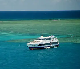
Great Barrier Reef
![]()
Mossman Gorge
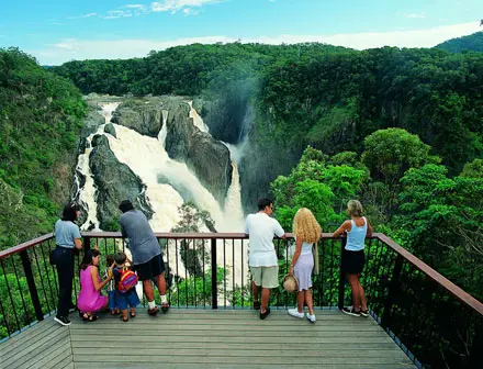
Barron Falls near Kuranda
![]()
Kuranda tourist railway
![]()
Daintree rainforest
![]()
Cape Tribulation
![]()
Crocodile at the Hartley's Creek Crocodile Farm
![]()
Green Island, Great Barrier Reef
|
Few Australians know Trinity Bay or could identify where it is on a map, but most would be very familiar with the two towns built on its shores that have become the jewels in the tourism crown of North Queensland - Port Douglas and Cairns.
![]()
Cairns, at the bay's southern end, having developed as a railhead and major port for exporting sugar cane, gold, metals, minerals and agricultural products from surrounding coastal areas and the Atherton Tableland region, has become the hub of tourism - both inland and offshore - for North Queensland. The former mining and timber port of Port Douglas, at the bay's northern end, has grown into an upmarket holiday resort town.
Port Douglas
![]()
Port Douglas has boomed as a tourist destination in recent years, not just because of its beautiful beaches, many restaurants, golf courses, and five star resorts, but because of its location, being adjacent to two World Heritage areas, the Great Barrier Reef and the Daintree Rainforest. Not far offshore is the northern section of the Great Barrier Reef where visitors flock in their thousands to dive on it during the winter months. Numerous companies run daily trips from the marina to the outer reef and the Low Isles for scuba diving and snorkelling.
Inland is the old sugar town of Mossman, the gateway to Mossman Gorge and the World Heritage listed Wet Tropics area. To the north in Daintree National Park is the stunningly beautiful Cape Tribulation, thus named by Lt. James Cook on 10th June 1770 after his ship ran aground on a reef near the site, "because here began all our Troubles".
Every year Port Douglas attracts tourist and locals alike to two significant festival periods. The original and world renowned festival the Port Douglas Carnivale is held around the end of May and runs for 10 days over two weekends beginning with the Macrossan Street Parade attracting over 10,000 people. The second festival period is held over two weekends in October and consists of the 'Footprints Music Festival' an Eco / Arts Festival & 'Porttoberfest' a Far Northern Queensland Beer Festival. Both periods showcase and celebrate the regions unique tropical island like lifestyle. Kite surfing is popular at the southern end of Four Mile Beach, particularly during the winter months when trade winds blow from the South.
The Port Douglas township was established in 1877 after the discovery of gold at Hodgkinson River. It grew quickly, and at its peak Port Douglas had a population of 12,000 and 27 hotels. With the construction of the Mulligan Highway it serviced towns as far away as Herberton. Other parts of the area were established with timber cutting occurring in the area surrounding the Daintree River and with settlement starting to occur on lots around the Mossman River by 1880.
When the Kuranda Railway from Cairns to Kuranda was completed in 1891, the importance of Port Douglas dwindled along with its population. A cyclone in 1911 which demolished all but two buildings in the town also had a significant impact. At its nadir in 1960 the town, by then little more than a fishing village, had a population of 100. In the mid-1980s, tourism boomed in the region after investor Christopher Skase financed the construction of the world-class Sheraton Mirage at Port Douglas.
Port Douglas today has a permanent population was about 3000, however the town's population can often double with the influx of tourists during the peak tourism season May-September. The town is named in honour of former Premier of Queensland, John Douglas. Previous names for the town included Terrigal, Island Point, Port Owen and Salisbury.
Cairns
![]()
Though the sugar industry is still a major income producer for Cairns, tourism is number one these days and this is reflected in the way the city has opened its doors and laid out the welcome mat for visitors from all over the world. The city is very visitor friendly - when walking on the Esplanade by the swimming lagoon on the ocean side, or the many cafes, restaurants and shops on the city side, one feels safe and comfortable, even late at night when all these visitor facilities are still open.
Cairns' main appeal to visitors is its tropical climate and proximity to many attractions, which visitors tend to visit while using Cairns as a base. The Great Barrier Reef can be reached in less than an hour by boat. Daintree National Park and Cape Tribulation, about 130 km north of Cairns, are popular areas for experiencing a tropical rainforest. It is also a starting point for people wanting to explore Cooktown, Cape York Peninsula, and the Atherton Tableland and to travel on one of Australia's finest tourist railways to the rainforest village of Kuranda.
The city has used its natural surroundings to its advantage, with the construction of several small theme parks for tourists. Among them are Rainforestation Nature Park, Tjapukai Aboriginal Cultural Park, and Kuranda Skyrail Rainforest Cableway, which extends for 7.5 km over World Heritage rainforest.
Cairns, which was named after William Wellington Cairns (the then Governor of Queensland), was formed to serve miners heading for the Hodgkinson River goldfield, but experienced a decline when an easier route was discovered from Port Douglas.
Cairns is located about 1,700 km from Brisbane, and 2,420 km from Sydney by road. A rapidly expanding city, it has a population of 122,731 (2006 census).
Climate; when to go there: Far North Queensland experiences a warm Tropical monsoon climate. A wet season with tropical monsoons runs from December to April, with a relatively dry season from May to November, though showers are frequent for most of this period. Mean rainfall of Cairns is 1,992.8 millimetres (78.5 in). The township of Babinda at the southern end of the city is one of Australia's wettest towns, recording an annual rainfall of over 4,200 millimetres. It has hot, humid summers and milder temperatures in winter. Mean temperatures vary from 25.7 °C in July to 31.4 °C in January. Monsoonal activity during the wet season occasionally causes major flooding of the Barron and Mulgrave Rivers, cutting off road and rail access to the city.
The dry season is by far the most popular time to visit Far North Queensland, with the peak during the July school holidays each year. The wet season's climate deters many for visiting the region during these months, however it is then that the tropical rainforests are at their greenest and the wildlife at its most active. The rivers are also fast flowing and full, meaning the waterfalls of the of Atherton Tableland are at their most spectacular.
|