| North West and Highlands of Tasmania: Traveller's Guide |

Waterfalls: there are numerous waterfalls along the escarpment of Tasmania's central highlands. Guide Falls, Detention, Forth and Dip Falls can all be accessed by roads off Tasman Highway. Other waterfalls are to be found throughout the Great Western Tiers.


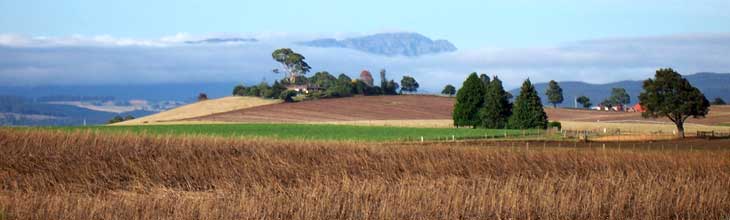
Burnie: situated on Emu Bay at the mouth of the Emu River, Burnie is Tasmania's third largest city and port for the rich agricultural and mineral mining activities of the region. It makes a great base for exploring the region due to its central position and extensive facilties.
Deloraine: the gateway to the Great Western Tiers, Deloraine is one of those delightful country towns that takes you by surprise and remains in your memory for a long time.

Walks of the North West: North West Tasmania is a productive farming and forested region with a wide variation in topography. The rugged coastline, alpine areas, network of rivers and limestone karsts, make it an attractive and challenging place for bushwalkers.
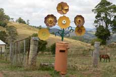
Wilmot: The quaint village of Wilmot is home to the original Coles store (drop in for a souvenir). The road from Wilmot to Devonport is lined with the most interesting and unique array of letterboxes you are ever likely to see.

Village of Lower Crackpot: a whimsical model village built to 1/5th scale at Tasmazia, a crazy complex located in the wonderfully named town of Promised Land. Each building has a story to tell, and is connected to real people. The village is dedicated to all those in middle life who, in this new economic age, are thrown onto the scrap heap, there to start again, some way.
Elizabeth Town: midway between Devonport and Launceston, Elizabeth Town is a food lovers delight. Sample cheeses at Ashgrove cheese factory then have a snack at the Bakery Cafe and spoil yourself silly with the delights on offer at the Christmas Hills Raspberry farm and Cafe.
|

Devonport: to many visitors to Tasmania, Devonport is primarily known as the port for the Spirit of Tasmania car and passenger ferries which make daily 10-hour trips between Melbourne and Devonport. It makes a great base and starting point for exploring Tasmania's north west.

Bass Highway: upon arrival in Devonport after sailing overnight aboard the Sprit of Tasmania ferry from Melbourne, there's something magic about heading off along the coastal road from Devonport to Burnie and beyond just after sunrise with the road to yourself, and cows grazing on the lush green grass beside the shoreline. It's a great day's drive that will take you all the way to Marrawah on the west coast if you are so inclined, visiting the many coastal towns on Bass Strait along the way.

|

Don River Railway: a museum celebrating Tasmania's trains of yesteryear. Don't miss the leisurely tourist train ride along the banks of the Don River to Coles Beach.

Raspberry delights: when you've just come off the Spirit of Tasmania ferry and you've eager to sample the delights that Tasmania has to offer, a great place to start is Christmas Hills Rasperrty Farm and Cafe at Elizabeth Town. The house speciality - Morning Craving - is my absolute favourute.

Westbury: a classic Georgian village surrounded by hedgerows and lanes reminiscent of England. Westbury has numerous museums, housing collections of agricultural machinery, antique steam engines, vintage cars, 19th century toys and historic furniture.
|
| Cross Country Waliking Trails |
 The Overland Track: Australia's most famous walk runs for 73 km across the Cradle Mountain Lake St Clair National Park. The northern start is at Waldheim in the north and the southern terminus is at Cynthia Bay beside Lake St Clair. The track crosses the highest region of Tasmania passing many of the highest peaks in the state. The scenery is glacial with many magnificent lakes, cliffs, cirques and waterfalls. One of the track's biggest attractions is that the scenery keeps changing as you pass through the park - there is a wide variety of landforms and vegetation and every day is different. The Overland Track: Australia's most famous walk runs for 73 km across the Cradle Mountain Lake St Clair National Park. The northern start is at Waldheim in the north and the southern terminus is at Cynthia Bay beside Lake St Clair. The track crosses the highest region of Tasmania passing many of the highest peaks in the state. The scenery is glacial with many magnificent lakes, cliffs, cirques and waterfalls. One of the track's biggest attractions is that the scenery keeps changing as you pass through the park - there is a wide variety of landforms and vegetation and every day is different.
More ...

Nearing the peak of Cradle Mountain
The Walls of Jerusalem: this mountainous area is part of the extensive central plateau of Tasmania. A good track is provided from the closest road and the main valley of the Walls around Lake Salome can be visited as a day walk. Most prefer to explore further and two day walks with an overnight campsite is the most popular trip. Camping platforms have been provided in the entrance to the Walls below Herods Gate. This is also a good area for experienced walkers as there are multiple multi-day approaches across the Central Plateau to the Walls.
More ...

Currie Harbour, King Island
Currie Heritage Harbourside Walk: All visitors to king Island are recommended to take this walk from the township of Currie as it gives a fairly complete picture as to what King Island is all about. The walk includes Currie's fishing boat harbour, the island's Cultural Centre, King Island Museum, Currie Lighthouse (tours can be arranged), British Admiral beach and the Netherby and Blencathra wrecksites.
More ...
|
 Tasmanian Trail: Runs from Devonport in the north to Dover, to the south of Hobart. The trail is 460 km long and consists of 15 sections. Each section is approximately one day's journey for a horse rider or cyclist. The trail can be hiked, or riden by bike or on horseback, but its use of roads and other vehicle tracks means certain sections are not always appealing to walkers. The track runs mainly through state forest, national parks and other reserves. The trail often leaves valleys to seek ridge lines which then offer many scenic outlooks. Tasmanian Trail: Runs from Devonport in the north to Dover, to the south of Hobart. The trail is 460 km long and consists of 15 sections. Each section is approximately one day's journey for a horse rider or cyclist. The trail can be hiked, or riden by bike or on horseback, but its use of roads and other vehicle tracks means certain sections are not always appealing to walkers. The track runs mainly through state forest, national parks and other reserves. The trail often leaves valleys to seek ridge lines which then offer many scenic outlooks.
The trail commences with a gentle grade on a made road from Devonport which runs beside the Mersey river. It soon enters rougher terrain including the Cluan Tiers, Great Western Tiers and then climbs into the Central Highlands. The trail then passes through Great Lakes region across the highlands to the Derwent River. At New Norfolk the trail leaves the Derwent and climbs over the mountain pass of the old stock route to the Huon River valley using a track around the ‘back’ of Hobart’s Mount Wellington.
The towns the track passes through (or near) are Latrobe, Railton, Sheffield, (Deloraine), Bracknell, Arthurs Lake, Miena, Bronte Park, Ouse, Bushy Park, Glenora, New Norfolk, Lachlan, Judbury, (Geeveston) and Dover.
More ...

Penguin Cradle Trail: This trail runs for 76 km from the seaside town of Penguin to the Cradle Mountain Lake St Clair National Park, and primarily follows the valley of the Leven River to near its source then follows the crest of the Black Bluff Range to the Cradle Mountain area. It can be combined with the Overland Track into an excellent 2 week walk.
The track is not well known with visitors. The most spectacular section of it, is where it passes through the Leven Canyon - this has scenery as good as anywhere else in the state. In the north, parts of the track are often obscured by bracken and fallen trees. Experienced walkers will have little trouble following it but do not expect the well marked track and regular signposts that are seen on the Overland Track.
More ...
Other Walks: Calcified Forest (King Is.); The Nut; Fern Glade; Leven Canyon; Alum Cliffs; Springlawn Nature Walk; King Island Wilderness Walks
See also: Tasmanian Cross Country Walks and Hikes
|
|
|