|
![]()
Lucky Bay, Cape Le Grand National Park

Twilight Beach, Esperance
![]()
Targon Point, Cape Arid
![]()
Whales come close to shore at Cape Ann
Natural Bridge near Albany
![]()
Tingle Tree, near Walpole
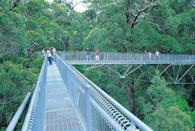
Valley of The Giants Treetop Walk
![]()
Pt. D'Entrecasteaux
![]()
Climbing the Gloucester Tree, Pemberton
![]()
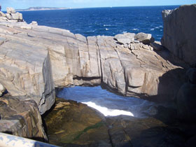
Meeting of the oceans at Cape Leeuwin
![]()
Cape Leeuwin lighthouse and lighthouse keeper's cottages
|
The coastal region of Western Australia's Great Southern is well known to the people of Western Australia as an area of natural beauty. For many it is their summer playground, with clean beaches, beautiful coastal vistas that extend to the horizon and beyond, and rugged outcrops of granite dotting both the picturseque coastline and the hinterland.
Travellers who cross the Nullarbor Plain by road on their way to Perth have the option at Norseman to travel north via Kalgoorlie or south via the South Coast and the towns of Esperance and Albany. Those who opt for the latter are in for a treat as the route takes them through some of the most picturesque coastal areas in southern Australia, before continuing through the south-west and the Margaret River wine region and on to Perth.
Location: south coast of Western Australia
Length: 814 km
Minimum duration: 2 days. Recommended minimum: 4 days
The journey: The drive follows the South Coast Highway between Esperance in the east and Walpole in the west. At Walpole, the South Coast Highway meets the South Western Highway, which continues in a north westerly direction through the Karri forests of Manjimup, Northcliff and Pemberton into Western Australia's South West region. Our journey terminates near Augusta at Cape Leeuwin, the extreme south west corner of Australia.
Esperance: when travelling from east to west via the South Coast, Esperance is the first port of call. The ocean here is crystal clear, the waters are a deep aqua colour; the coast is lined with stunning pink granite outcrops and offshore there are a myriad islands. Seals, dolphins and whales (in season) abound.
Cape Le Grand: A major nearby attraction, 56 km from Esperance town centre, is Cape Le Grand National Park, which offers a stunningly picturesque coast of largely granite terrain and sheltered white sand beaches. It is a popular spot for beachcombing, recreational fishing, and is enjoyed by four wheel drive enthusiasts and hikers.

Cape Arid: 120km east of Esperance, Cape Arid offers more spectacular coastal scenery dominated by granite outcrops. Being home to more than 160 bird species, it is an important park for the conservation of birds in Western Australia. There are plenty of coastal walking trails to various fishing and swimming spots. Photos
Fitzgerald River National Park: Point Ann in Fitzgerald River National Park is the best shore-based locality in Australia to see the giant whales that visit our coasts each winter. In fact, it is one of only two places in Australia where southern right whales and humpbacks consistently come to calve in big numbers (the other being the head of the Bight in South Australia). Whales can be seen from the shore or the viewing platforms at Point Ann between July and November, sometimes just a few metres off the beach.
Stirling Range: this rugged mountain range rises spectacularly out of the surrounding plains. Located some 80km north of Albany, the Stirling Range National Park offers visitors a wonderful opportunity to explore an entire mountain range still in its natural state. This rugged mountain range has something for everyone. The beautiful, ever changing scenery provides wonderful photographic and painting opportunities, and the mountain rock faces challenge the most experienced abseilers and rock climbers. The most climbed mountain in the Stirling Ranges is the chiselled mass of Bluff Knoll.
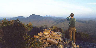
Stirling Range from Talyuberlup Peak
Porongurup Range: Although only 12 kilometres long and 670 metres at its highest point, the Porongurup Range is renowned for its beauty. It is clothed in a luxuriant forest of giant karri trees and the understorey puts on a brilliant display of wildflowers during spring and early summer. Pathway allow visitors to wander through the shade of ancient forests, discover fossils underfoot, see a rainbow of wildflowers, sit and listen to a symphony of bird songs, all with the magnificent views of the Stirling and Porongurup Ranges as your backdrop. 40 km north of Albany.
Albany: the largest centre in Western Australia outside the Perth metropolitan area, Albany is the perfect base from which to explore the many beauty spots - both coastal and inland - of the Great Southern. Sited on the shores of one of Australia's great natural harbours, Albany is surrounded by stunning coastal scenery, calm harbour beaches and the beautiful Stirling and Porongurup mountains ranges in the hinterland with easy access walking tracks.
![]()
Elephant Cove, William Bay National Park, near Denmark
Denmark: a once thriving timber town on Wilson Inlet, Denmark is today a popular resort centre, the nearby coast offering visitors swimming, fishing and surfing. Denmark has a range of activities and attractions for young and old, including some of Australia's finest wineries, a wealth of arts and crafts, cosy cafés, gourmet foods, exhibitions, walking trails under a forest canopy, wildflowers and whale watching.
Walpole: the southern gateway to Western Australia's Karri forests, Walpole is home to the giant tingle trees and the Valley of the Giants. The Treetop Walk gives intimate access this world famous forest of gigantic tingle trees - from the forest floor and from 40 metres up in the canopy. Then descend to the boardwalks below and explore the "Ancient Empire" - a grove of impressive veteran tingle trees.
Northcliff: a small timber town in the heart of the Karri forests on the way to Pemberton. Northcliff is the entry point to the dramatic coastal scenery of Point D'Entrecasteaux and Windy Harbour township. The Point D'Entrecasteaux viewing platform is high up on the cliffs some 100 metres above the ocean. A walking trail that circumnavigates the point.
Windy Harbour: at Northcliffe, follow the signs to the coastal holiday settlement of Windy Harbour (54km return drive from Northcliffe). The township is surrounded by D'Entrecasteaux National Park. Cape D'Entrecasteaux, within the park, has some spectacular cliffs and sea caves, offering some excellent photo opportunities from a number of coastal lookouts.
Pemberton: located midway between the South-west and South Coast regions, this charming timber town is nestled deep in the karri forests of WA's south-west. It has its own sub-wine region, a tourist railway through the forests, waterfalls, and the Gloucester Tree - a 61m tall lookout tree which can be climbed.
Augusta: upon reaching Karridale, turn left for the 14km drive to Augusta. Beyond this pretty holiday town is Flinders Bay, where navigator Matthew Flinders began his circumnavigation of Australia in 1801. At the western end of Flinders Bay is Cape Leeuwin, the most south-westerly point of the Australian mainland where the Southern and Pacific Oceans meets. Whales are often seen off the cape between June and October.
Great Southern Wine and Food Trail: located within a one-hour drive of Albany are five dynamic sub-wine regions which collectively form the Great Southern Wine Region. Their high quality wines have forged an enviable reputation internationally of late. Teamed with these fine wines are a diverse range of local produce. Berries, olive oils, cherries and asparagus are seasonal favourites.
The hinterland provides such tastes as fresh lamb, beef, venison and poultry, together with freshwater delicacies such as trout, marron (freshwater crayfish) and yabbies. The bounty of the sea adds to the gourmet experience, with local seafood and Albany's famous oysters and mussels found in local markets and fine restaurants.

|